


Violent storms driving the worst floods for a generation now threaten to open the gates to a freak mid-spring snowstorm.
Winter ‘freeze’ warnings have been issued across more than 10 states ahead of a ‘temperature whiplash’.
Frenzied storms churning the country will bring up to a foot of snow as the mercury nosedives around 30F below average.
Weather Channel meteorologist Robb Ellis said: “A dip in the jet stream is going to slide to the east and that means some temperature changes.
Eastern states will be taken 'back into winter'
ACCUWEATHER
“For the east coast it is a cooldown and cooler than average temperatures are expected.
“There will be showers and storms in the southeast with some snow and mixed precipitation in the Great Lakes and the Northeast.”
The Weather Channel’s Chris DeWeese added: “Cooler temperatures are returning across much of the East, which will see a temperature whiplash from unseasonable warmth to highs more than 10 degrees below average.”
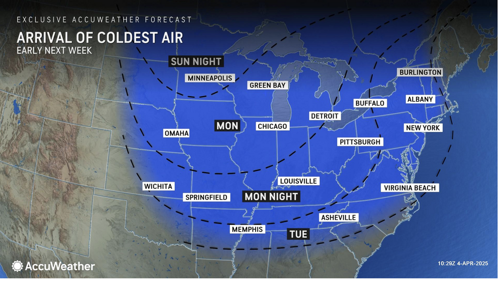
A flush of cold Arctic air pulled in from Canada by jet-stream driven winds will take eastern states ‘back into winter’.
A further three inches of rain will drench flood-stricken regions as snow-laden gusts sweep the Great Lakes.
Freezing conditions will be dragged in by a ‘dramatic bulge’ in the jet stream as some places brace for a ‘return to winter’.
AccuWeather meteorologist Alex DaSilva said: “It will feel like winter for many across the Midwest and Northeast at the start of the week as Arctic air surges south from Canada.
LATEST DEVELOPMENTS:
A further three inches of rain will drench flood-stricken regions as snow-laden gusts sweep the Great Lakes
ACCUWEATHER
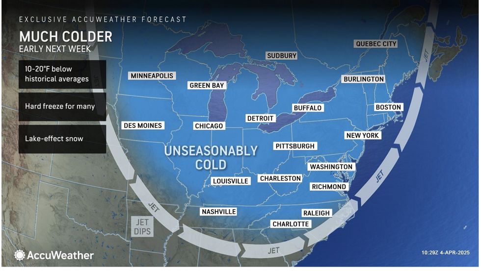
“Temperatures across much of the Midwest and interior Northeast will be as much as 10F to 20F below the historical average, and with a gusty wind out of the northwest, conditions will feel very chilly.
“Amid the cooler pattern, moisture advancing southward out of Canada and into the northern tier of the country will bring chances for wintery precipitation.”
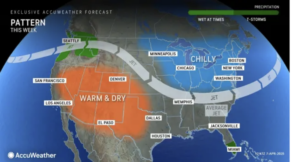
As the east freezes, though, a freak nationwide temperature split will push the mercury in Arizona to 100F.
AccuWeather meteorologist Alyssa Glenny said: “A contrasting pattern will see Southwest cities soar to 100 degrees while visibility-reducing snow squalls and brisk conditions impact the Great Lakes and interior Northeast.
“While southwestern states bake in the first 100F day of the year, people in the Northeast will face the total opposite end of the spectrum as daytime highs barely reach beyond freezing.”
It is the latest in a roller-coaster spring in which devastating storms have plunged southeastern regions into what is being called the worst flooding in a generation.
Battling hot and cold air masses straddling a vigorous jet stream have fuelled the assault.
As the east freezes, though, a freak nationwide temperature split will push the mercury in Arizona to 100F
ACCUWEATHER
As winter returns to eastern states, the rest of the country is braced for the next storm to power through.
Jim Dale, US meteorologist for British Weather Services and co-author of ‘Surviving Extreme Weather’, said: “Behind the storms a cold plunge will bring snow and a what will feel like a return to winter in parts of the United States.
“Although this is largely dry, cold air, when it passes over the Great Lakes, there will be a risk of snow.
“Then, another system follows behind brining the risk of further stormy conditions and rain into the weekend, and with this will come the danger of further flooding.”
A spokesman for the US National Weather Service added: “Highs in the 30Fs and 40Fs will represent a 20F to 30F departure from average.
“The heaviest snow should accumulate over interior portions of the Northeast where four to eight inches are expected.”
