Storm warning: US to be battered by a series of huge storms
The Weather Channel
Almost a foot of rain could flood western states this week
Don't Miss
Most Read
Trending on GB News
A ‘parade’ of storms steered into the Pacific gulf coast by a ferocious jet stream threatens a 1000-mile deluge across the US.
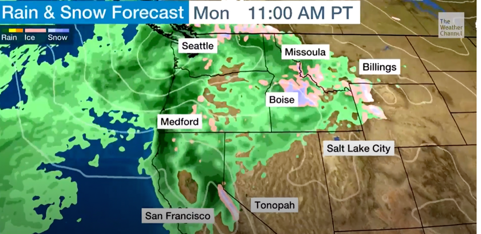
Almost a foot of rain could flood western states this week as ‘at least three’ major storm systems dump their load on the region.
Storms will hit as temperatures plummet in a -10C Arctic plunge to bring the added threat of snow, experts say.
Torrential downpours stretching from coastal states including California across to Oregon and Colorado will hammer the region through this week.

Low pressure swirls around the north west coast
The Weather Channel
Flooding will be a ‘significant concern’ according to experts who blame a jet stream turbo-charged by warm sea temperatures beneath cooling winter air streams.
Jim Dale, US weather correspondent and meteorologist for British Weather Services, said: “There are at least two or three storms being pulled into the west coast by the jet stream which is currently being invigorated as air temperatures fall over higher-than-average ocean temperatures.
“These are going to drop quite a lot of rain, and across Wisconsin, Oregon, California and even as far in as Colorado, flooding is going to be a significant concern through the rest of the week.
“I would not be surprised to see 10 inches of rain in parts, maybe a bit more, and this is going to come in spades rather than in bits.”
The jet stream will turn into a ‘conveyor belt’ also whipping up strong winds in exposed regions, he added.
Volatile weather patterns have been driven by tropical moisture sweeping north from the Gulf of Mexico into bitter air from the Arctic.
The plunging jet stream has forced cold air over the Rockies dipping temperatures and driving storm formation.
Low-pressure systems will arrive back-to-back through the coming days from the Gulf of Alaska.
The Northwest coast and surrounding states will bear the brunt of the deluge to face a ‘parade of storms’, according to The Weather Channel.
Weather Channel meteorologist Orelon Sidney said: “All aboard the rain train in the northwest.
“We have low-pressure storms that will be tracking out of the Gulf of Alaska, headed into the Northwest.
“It’s breezy, and of course conditions are cool, so over highest elevations we are probably looking at snow, and we are looking at some heavy rain.
“As the winds pick up, that’s how you’ll know the next low-pressure is pushing through, then the winds will die down, and then they will pick up again and that’s how you’ll know the next low is on your doorstep.”
Also eyeing up the south coast, yet another tropical disturbance has weather experts warning of the potential for ‘hazardous conditions’.
Tropical Storm Pilar is currently heading towards the Baja California Peninsular on a northwest track across the Pacific.
It is expected to die out by the middle of the week, according to the National Hurricane Centre (NOAA), after winds peak at 50mph.
A NOAA spokesman said: “Pilar is moving toward the west-northwest near 8 mph (13 km/h), and this motion is expected to continue through [Sunday night].
“A north-westward motion is forecast to begin early Monday and continue through
midweek.
“Gradual weakening is forecast during the next few days, and Pilar is expected to become a remnant low by Tuesday.”


