


America is on alert for the second tropical storm in a week threatening torrential downpours and a mammoth sea surge.
The full thrust of the storm, due during the next 24 hours will strike Mexico although the southern US including Texas is braced for collateral impact.
It comes after Tropical Storm Alberto pounced at the end of last week and marks a volatile start to the 2024 hurricane season.
AccuWeather lead tropical meteorologist Alex DaSilva said: “Downpours and storm surge could compound issues caused by Tropical Storm Alberto while drenching rain could reach areas dealing with drought in the Rio Grande Valley of Texas.”
US weather: Southern states on alert amid threat of mammoth sea surge from tropical storm
Accuweather
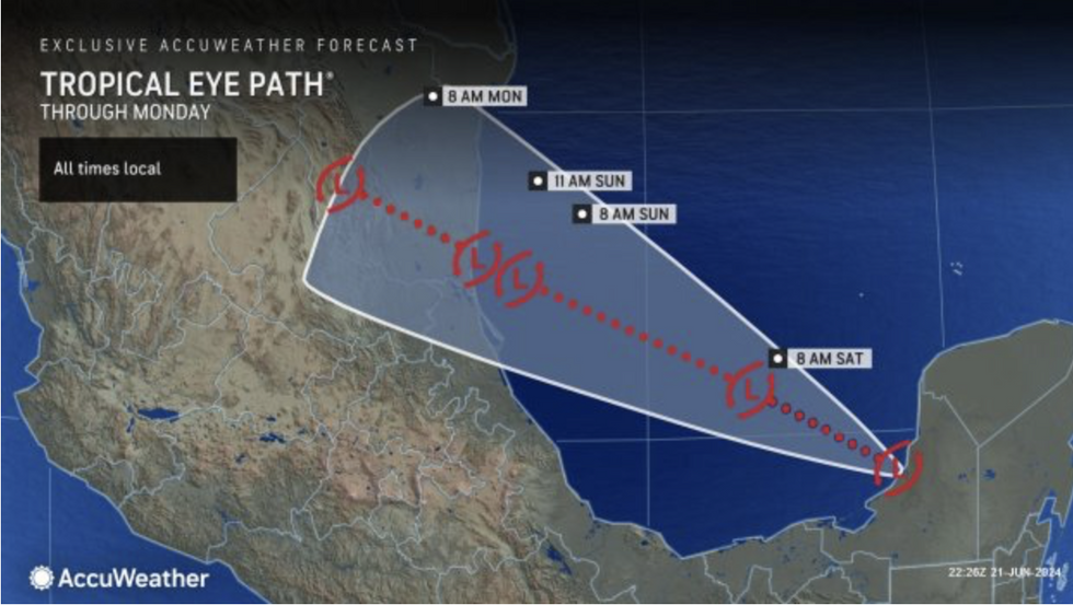
The storm was last night around 90 miles northeast of Tampico, Mexico, on a collision course with Central America.
It threatens to put the southern Texas shoreline on flash-flood alert whipping up a three-feet storm surge.
Up to 14 inches of rain is possible before the storm blows itself out bringing the added risk of mudslides.
An AccuWeather spokesman said: “Portions of the lower Rio Grande Valley of Texas are currently experiencing long-term drought conditions.
“Rain could be beneficial in South Texas, but downpours could also lead to dangerous flash flooding.”
US LATEST: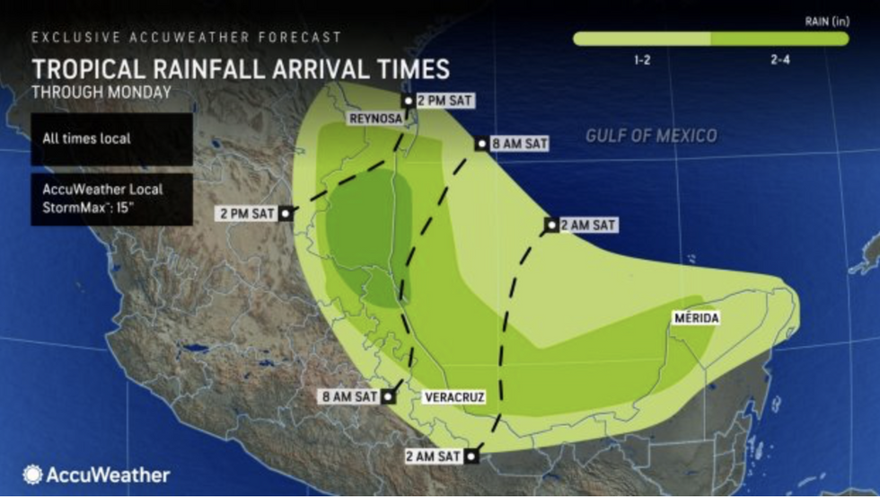
Torrential deluge ahead
AccuWeather
The cyclone, currently on course to hit Mexico, will spawn an angry ‘gyre’ – a huge, churning low-pressure cell capable of supercharging the mother storm.
Mr DaSilva said: “This feature in the southwestern Gulf that we are monitoring is a piece of the Central America gyre that is breaking away and rolling west-northwestward.
“A gyre is a large, slowly spinning area of low-pressure that often enhances showers and thunderstorms in its circle of influence.”
Unusually high ocean temperatures driven by a freak heatwave boiling America could drive storms this season, he added.
He said: “Tropical storms and hurricanes love to feed off warm ocean water.
“The warmer the oceans are, the more favourable the environment will be for tropical development and intensification.”

2024 US storm names
Accuweather
A plume of tropical moisture over the warm waters of the Gulf of Mexico will feed a spate of tropical storms, experts warn.
Texas and Florida are first in the firing line as the hurricane season kicks off, although the risk will spread.
Jim Dale, US meteorologist for British Weather Services, said: “The Gulf of Mexico is full of moisture, and this will be a driver for thunderstorms across the region in addition to the tropical storms that are starting to come in from the Atlantic.
“We are at the start of the season, and it is expected to be an active period, particularly as the ocean temperatures are high and this is going to feed tropical storms.
“For the time being, it is the south that is in the firing line, but there is a growing risk of this conveyor belt moving further north, following the jet stream.”
The US National Hurricane Centre last night warned heavy rain sweeping in from the Gulf of Mexico will trigger flooding.
A spokesman said: “Disorganized showers and thunderstorms continue in association with a broad area of low pressure located about 90 miles northeast of Tampico, Mexico.
“Regardless of development, heavy rainfall could cause localised flooding across portions of north-eastern Mexico and Deep South Texas during the next day or so.”
