


A ‘severe weather outbreak’ bulldozing more than 20 states will unleash a swarm of 100mph, hail-laden super-tornadoes.
Deadly storms whipping up massive dust clouds while driving deadly wildfires have sparked near-nationwide warnings affecting as many as 170 million Americans.
Freak ‘nocturnal tornadoes’ – powerful twisters which strike after dark and are more than twice as deadly as their daytime counterparts – will rip up trees and knock out power supplies.
AccuWeather chief meteorologist Jonathan Porter said: “The risk of tornadoes will continue late into the night and early hours while people are asleep, which is extremely dangerous.
 US weather: ‘Severe outbreak’ to bulldoze over 20 states as 100mph, hail-laden super-tornadoes to strike
NOAA
“Nocturnal tornadoes are statistically two-and-a-half times more deadly compared to tornadoes that hit during daylight hours.
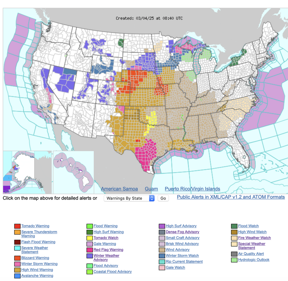
“The first severe weather outbreak of March could bring dangerous and disruptive impacts to two dozen states across the southern Plains, Midwest and East Coast with 170 million people are under the threat of severe thunderstorms.
“Gusty winds and blowing dust could create hazardous travel conditions at times.”
The US National Weather Service’s (NOAA) warnings map has been updated to a multi-coloured splatter of severe alerts.
A separate ‘major’ storm hurtling out of the Rockies threatens high winds, snow and blizzards.
US LATEST: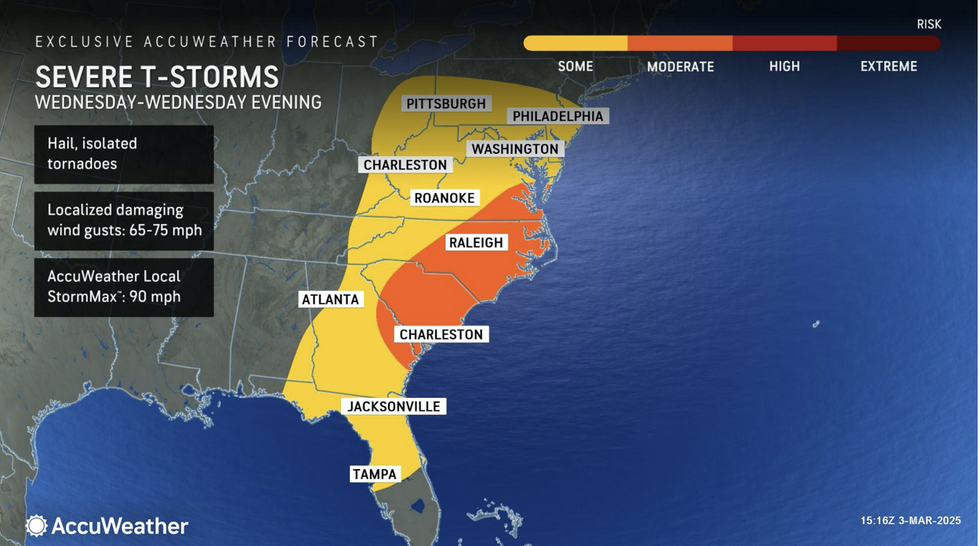
AccuWeather map show severe T-storms looming
AccuWeather
Further south, soaring temperatures and bone-dry gusts will feed the spectre of wildfires.
A NOAA spokesman said: “Widespread hazardous weather is expected across the central US as potent low pressure system treks through the Central Plains.
“The main threats for these storms will be very strong damaging winds, tornadoes, and at least some areas of large hail with heavy rainfall a concern for the Midwest and down into the Lower Mississippi Valley to the Mid-South region.
“There is also critical to extreme fire weather danger across much of the Southern High Plains going through to the middle part of the week.”
Meteorologists continue to blame the freak storm eruption on winter and summer air masses as the seasons change.
Bitterly cold Arctic air across northern states will lock horns with warmer plumes from the tropics.
As temperatures across Gulf and desert states hit 90F this week, thermometers across the north will stubbornly nudge freezing.
Cold, dry air hitting moist tropical air provides the ideal ingredients for volatile atmospheric winds and storms.
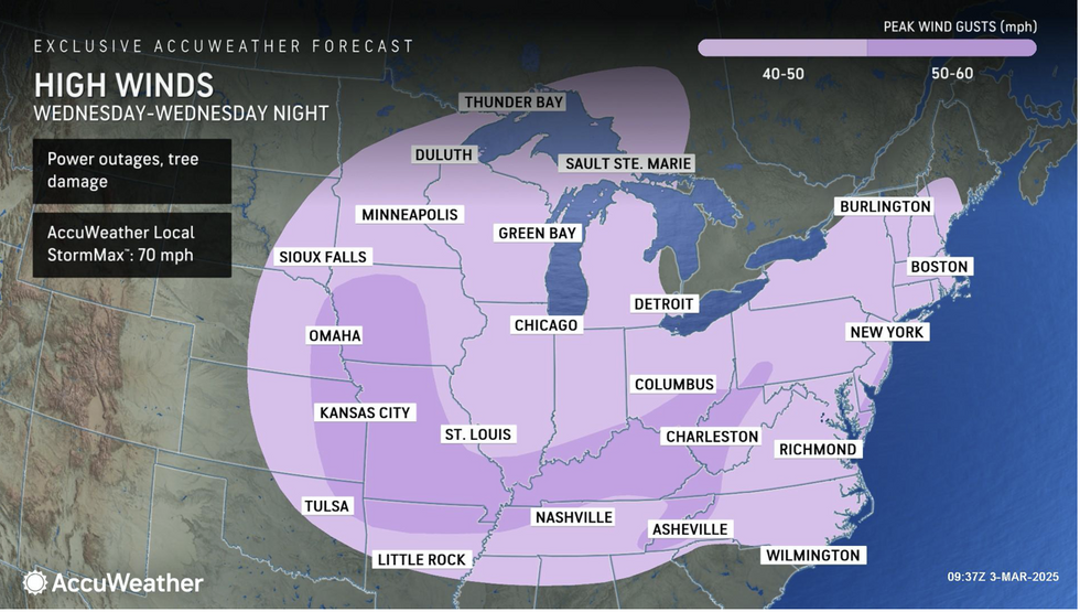
AccuWeather map shows high winds to batter east coast
AccuWeather
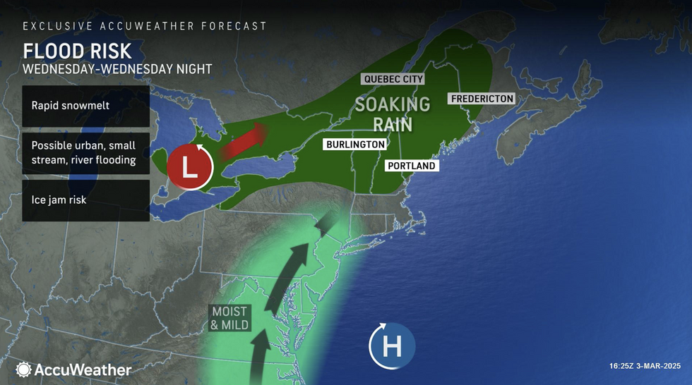
AccuWeather map shows east coast facing flood risk
AccuWeather
Jim Dale, US meteorologist for British Weather Services and co-author of ‘Surviving Extreme Weather’, said: “We are still watching this battle between the cold in the north and warmth coming in from the south, and this is always going to bring the ingredients for storms.
“Temperatures in some southern states could hit 90F in the coming days while it is still very cold further north, and here there will be a risk of snow.
“But where these two meet, we are always going to see a risk of storms and at this time of year, a growing risk of damaging tornadoes.”
Southern states have the added nightmare of dry winds and soaring temperatures driving wildfires.
NOAA has issued a raft of ‘red-flag’ fire warnings across the region as incendiary gusts fan the flames.
Porter said: “Conditions will be exceptionally windy and dangerously dry, and there is an extreme risk of fires sparking and spreading across eastern New Mexico and West Texas.
‘Gusty winds, downpours, hail and lightning could make for a very difficult drive to work and school for millions of people across northern Texas.
“We encourage families and businesses at risk of severe thunderstorms to review safety plans and ensure storm shelters and safe rooms are stocked with emergency supplies and ready for use.”
Most read


More


