


Monster storms ‘slicing through’ the snow-crippled US will drag record-breaking blizzards as far south as the Gulf Coast.
Some 110 million Americans are warned to stay indoors or wear gloves, hats and even face masks as temperatures hit unprecedented lows.
A freak surge from the North Pole will tail an army of strengthening storms whipping up crippling blizzards and feet of snow.
The US National Weather Service (NOAA) has issued around 15 Extreme Cold Warnings, with Advisories and Winter Storm warnings in force across much of the country.
A freak surge from the North Pole will tail an army of strengthening storms whipping up crippling blizzards and feet of snow
ACCUWEATHER
A spokesman said: “Record cold temperatures and dangerously cold wind chills will spill further southward into the Plains with below-average temperatures spanning much of the East.
“By Thursday morning, Arctic air will reach the Gulf Coast where temperatures will dip below freezing with numerous low-temperature records expected to be broken.
“Heavy mountain snow and light lower elevation snow across the northern Rockies through today will taper off as the next Pacific storm system enters the Northwest early Wednesday.
“Be sure to dress in layers including a hat, face mask, and gloves if you must go outside.”
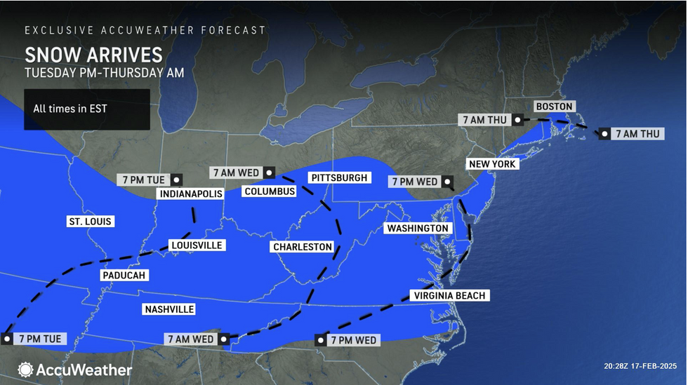
The next storm due mid-week will hit more than 110 million people, experts warn, before the volatile weather eases.
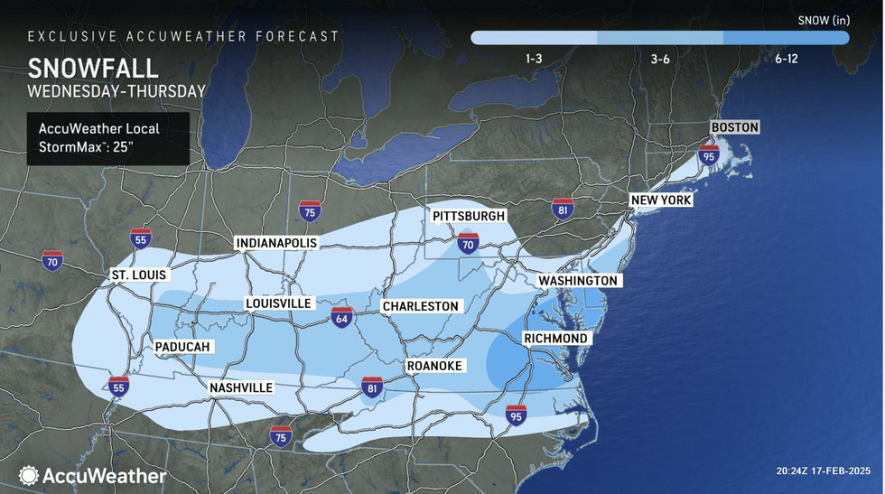
Up to 12 inches of snow is likely to blanket the Midwest and the Appalachians sparking warnings for ‘significant impacts’.
Those heading out are warned to prepare for major delays on all transport networks as building ice threatens to topple trees and down power lines.
LATEST DEVELOPMENTS:
Up to 12 inches of snow is likely to blanket the Midwest and the Appalachians sparking warnings for ‘significant impacts’
ACCUWEATHER
AccuWeather meteorologist Jonathan Porter said: “This February frenzy of relentless winter storms will bring another round of snow and ice to the Plains, Midwest, and mid-Atlantic.
“Slippery and hazardous conditions could shut down highways, delay or cancel thousands of flights, close schools, and disrupt business and supply chain operations
“A build-up of at least 0.25 of an inch of ice could snap tree branches, weigh down power lines and lead to power outages.”
Temperatures in parts will feel like -50C, according to NOAA, while real temperatures will fall around 30F below normal.
‘Howling winds’ sweeping the Great Lakes will trigger a double-whammy lake-effect snow blitz.
Porter said: “Rounds of lake-effect snow are expected across parts of the Great Lakes and interior Northeast.
“A burst of Arctic air will continue to expand from the Midwest, Great Lakes and central Plains to the Northeast this week.

Temperatures in parts will feel like -50C, according to NOAA
ACCUWEATHER
“Frigid temperatures between 15F and 30F below the historical averages combined with gusty winds will make real-feel temperatures plummet.”
A continuing battle between cold Arctic winds pushing south into mild tropical air will fuel the storm frenzy.
Heavy rain along the Pacific coast will bring a separate flood risk to western States, experts warn.
Jim Dale, US meteorologist for British Weather Services and co-author of ‘Surviving Extreme Weather’, said: “The cold front will continue to move across the US and where this meets milder air there is going to be a risk of storms.
“This is a classic set up for volatile atmospheric conditions, and there will be an ongoing risk of powerful storms through the week.
“To the northwest, a Pineapple Express system of moisture flowing in from the Pacific bringing heavy rain, and with any snowmelt, there will be a risk of flooding.”
