


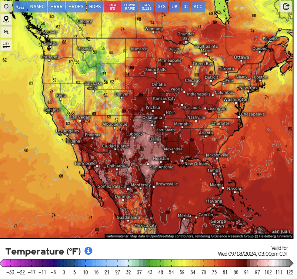
Battling weather fronts will unleash vicious storms as a 100F heat blast topples autumn temperature records.
Plumes of hot air from the Gulf of Mexico will put eastern states in the firing line for a late burst of summer.
Further to the northwest, however, thermometers will struggle as thunderstorms and torrential downpours erupt in the overlap.
Soaring temperatures show no sign of abating through the start of autumn, reaching as far north as New England and New York.
 100F heat blast to unleash vicious storms amid battling frontsWeather.US
Jim Dale, US meteorologist for British Weather Services, said: “The heat is building into heatwave conditions across the east of the country, coming out of the Gulf of Mexico.
“It is colder in the west, and to the north, but there is a chance this heat could spread to the western side of the states.
“It may miss the far north of the region, not reaching as far as Washington and the surrounding areas.”
Where hot and cold air masses meet, atmospheric instability will trigger violent storms, he warned.
“The risk of storms is still there,” he said.
US LATEST:“Where hot and cold air meet, there is always going to be instability, and that will bring torrential rain, thunder and the threat of tornadoes.
“However, in parts of the country, we are looking at temperatures of above 30C which is unusual for this late in the season, thanks to this plume coming out of the south.”
The US National Weather Service (NOAA) has issued alerts for strong winds and floods across Kansas, Wyoming, North Dakota and Montana.
Separate storms heading in from the Pacific coast will put north-western states on alert for thunder, it warned.
A spokesman said: “Another system approaching the Pacific Coast will bring some scattered showers and storms to the coastal Pacific Northwest, spreading southward into northern California and the central Great Basin.
“Temperature-wise, much of the northern tier of the central and eastern US as well as the Plains will remain much above average.
“Highs will be into the mid-to-upper 80s for portions of northern New England and the Upper Midwest Wednesday, and a handful of near record-tying or breaking highs approaching 100F will be possible for portions of the southern Plains on Thursday.”
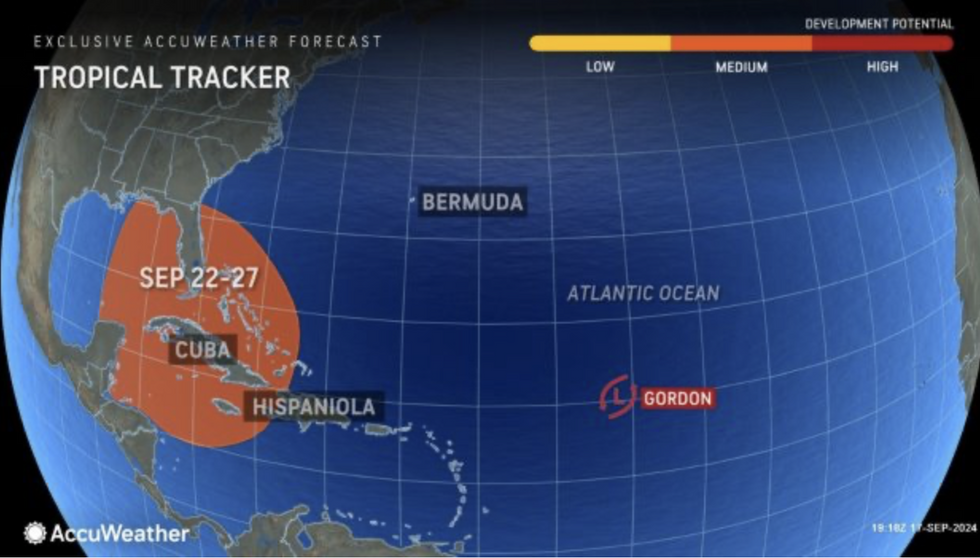
More tropical storms ahead
AccuWeather
Meanwhile, meteorologists are watching the hurricane season surge in the tropical Atlantic.
Tropical Storm Gordon formed this week followed by another tropical depression off the south US coast.
Further ‘home-grown’ tropical storms have started to spawn close to the coast of America, experts say.
Caribbean ocean temperatures, well above average, are helping drive the tempestuous outbreak.
AccuWeather meteorologist Alex DaSilva said: “Water temperatures at the surface and hundreds of feet deep are incredibly warm in the western Caribbean right now.
“A piece of energy is expected to break away from the Central American Gyre and move into the western Caribbean early next week, which is unusual for this time of year.
“Then we expect potential development that will be pulled to the north by a dip in the jet stream–the big question, will it be pulled into the eastern Gulf or the Atlantic off the Southeast coast.”
