US weather: Frenzy of tropical activity threatens RECORD hurricane season
Hurricane Irma caused widespread destruction in 2017
Meteorologists have issued fresh warnings for between 20 and 25 deadly storms
Don't Miss
Most Read
Trending on GB News
A ‘frenzy of tropical activity’ in the Atlantic threatens to set the scene for a potentially record 2024 hurricane season.
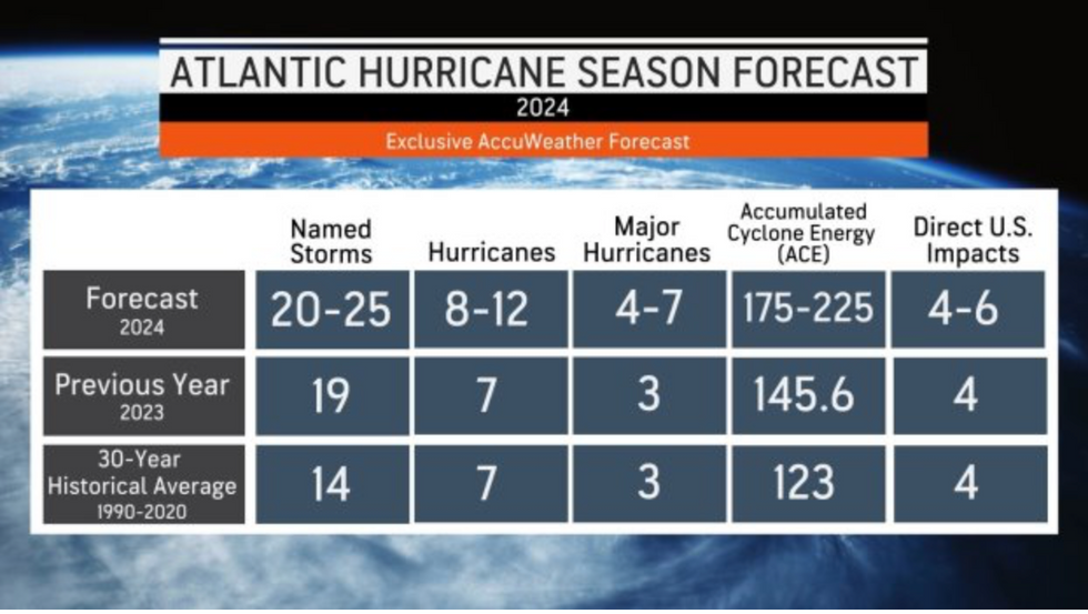
Meteorologists have issued fresh warnings for between 20 and 25 deadly storms, including up to 12 hurricanes and between four and seven major hurricanes.
‘Off the charts’ ocean temperatures will fuel the ‘explosion’ as experts warn residents and businesses in prone regions to prepare now.
AccuWeather lead hurricane forecaster Alex DaSilva said: “All indications are pointing toward a very active and potentially explosive Atlantic hurricane season in 2024.

Meteorologists have issued fresh warnings for between 20 and 25 deadly storms
Accuweather
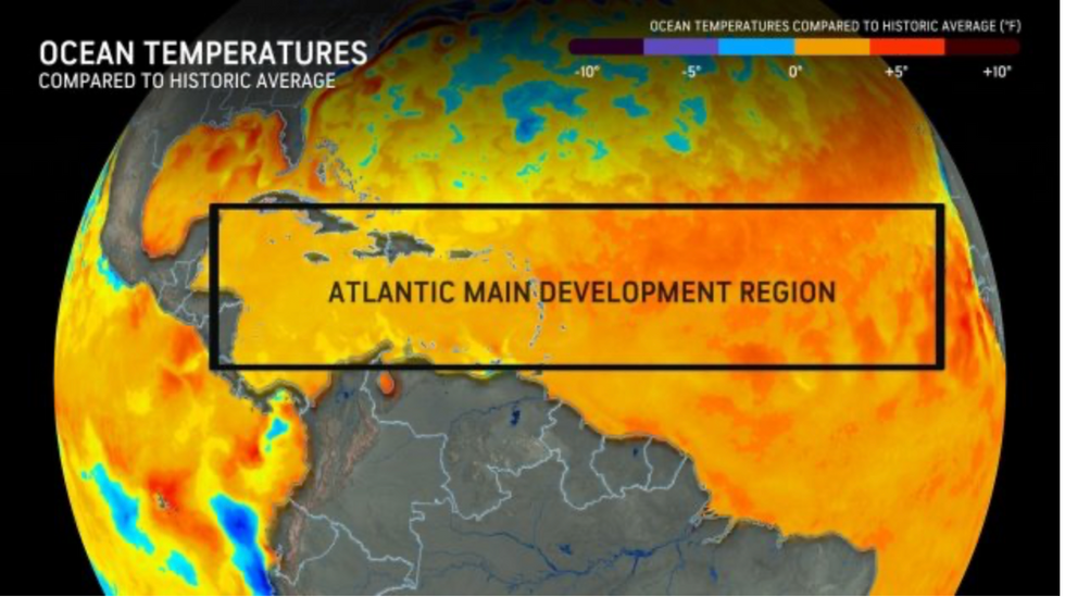
“Sea-surface temperatures are well above historical average across much of the Atlantic basin, especially across the Gulf of Mexico, Caribbean, and the Main Development Region.
“The 2024 Atlantic hurricane season is forecast to feature well above the historical average number of tropical storms, hurricanes, major hurricanes, and direct US impacts.”
Last year saw seven hurricanes form in the Atlantic, with 19 names storms and just three major hurricanes, according to AccuWeather figures.
This year could see a ‘dramatic shift’ thanks to sea temperatures already ‘jumping off the charts’, Mr DaSilva said.
Hurricanes usually form off the west coast of Africa, before travelling westwards towards the US.
As tropical features, they are fuelled by warm waters of the Atlantic near the Equator, sometimes gathering speeds of 150mph or more.
Warm sea waters provide the fuel for hurricane development, with Atlantic temperatures currently warmer than 2005 and 2020 – both major hurricane years.
LATEST DEVELOPMENTS:
- US weather forecast: Two freak winter storms to smash America with blizzards and inches of snow
- US weather: One of the ‘hottest summers on record’ with 'freakishly' high temperatures to drive triple-peak pollen explosion
- US weather: ‘Venomous’ heat plume to surge temperatures that could break spring records

Warm sea waters provide the fuel for hurricane development
Accuweather
This hurricane season could also be boosted by the transition of El Nino, which set in last year, to its counterpart, La Nina.
An El-Nino year is triggered when westerly Trade Winds slow or reverse, causing warm water to collect off the coast of South America.
The phenomenon can have significant impacts on weather patterns around the globe, as can La Nina, caused by cooling coastal waters.
A transition from El Nino to La Nina would drive disruptive weather patterns through the summer and into the hurricane season.
Jim Dale, US weather correspondent and meteorologist for British Weather Services, said: “It is now a watching brief to see whether the transition takes place from El Nino to La Nina, and this can have an effect on weather patterns going ahead into the summer and beyond.
“Warmer ocean waters provide the fuel for tropical storms and hurricanes, and with a general warming of the climate, there is no reason to think there won’t be a particularly active season this year.
“This is another product of rising global temperatures having dramatic effects on weather patterns, not just in the US, but around the globe.”
An Accuweather.com spokesperson added: “AccuWeather’s team of expert meteorologists is warning people and businesses to start preparing for a frenzy of tropical activity that could have major impacts on the United States this hurricane season.”
Meanwhile, thunderstorms continue to hit parts of the US with unsettled and disruptive weather forecast into the weekend.
Heavy rain threatens flash flooding as a ‘stalled’ weather front offloads across the south-east coast.
Further north, a freak Arctic blast driven by two late winter storms will bring further snow through the rest of the week.
A spokesperson for the National Weather Service (NOAA) said: “Moderate to heavy snow is possible over parts of the Cascades, Sierra Nevada and Northern Rockies; where between one to two feet of snow may accumulate by Friday morning.”


