Winter storm advisories November 2024
NOAA
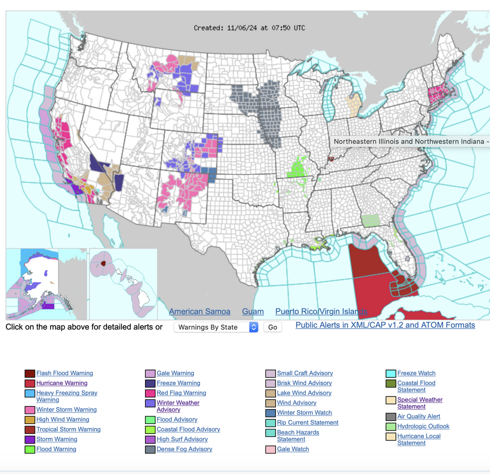
Warnings are in place across New Mexico, Colorado, Utah, Kansas and Nebraska
Don't Miss
Most Read
Trending on GB News
A freak pressure shift in the upper atmosphere will thrust a surge of Arctic air across the US triggering a spate of warnings for Polar gales and blankets of snow.
As the east coast braces for Hurricane Rafael, the west is on alert for temperatures to nosedive.
A powerful ‘trough’ of low pressure high in the atmosphere will plough a cold front across Pacific and central states.
The National Weather Service (NOAA) has issued winter storm warnings across New Mexico, Colorado, Utah, Kansas and Nebraska.
 Winter storm advisories November 2024NOAA
A spokesman said: “Make sure to bundle up as a strong upper-level trough is expected to quickly progress through the West pushing a cold front through the Rockies and Southwest.
“There are winter advisories, winter storm warnings, winter storm watches, wind advisories and high wind watches scattered from Montana to New Mexico.
“As arctic air plunges into the region temperatures will fall to the 30Fs and 40Fs across the valleys and drop to the single digits overnight in the cool spots.”
Powerful winds whipped up by clashing air masses will drive wildfires across heatwave-parched land further south.
NOAA ‘red-flag’ warnings have been issued across California where bone-dry gusts will fan the blaze.
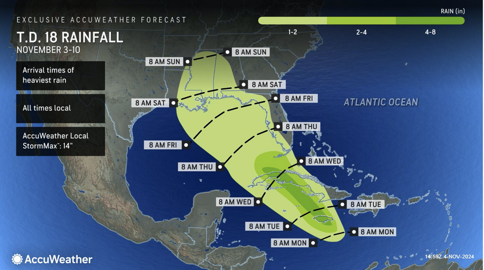
US LATEST: Rainfall in US as Hurricane Rafael loomsAccuWeather
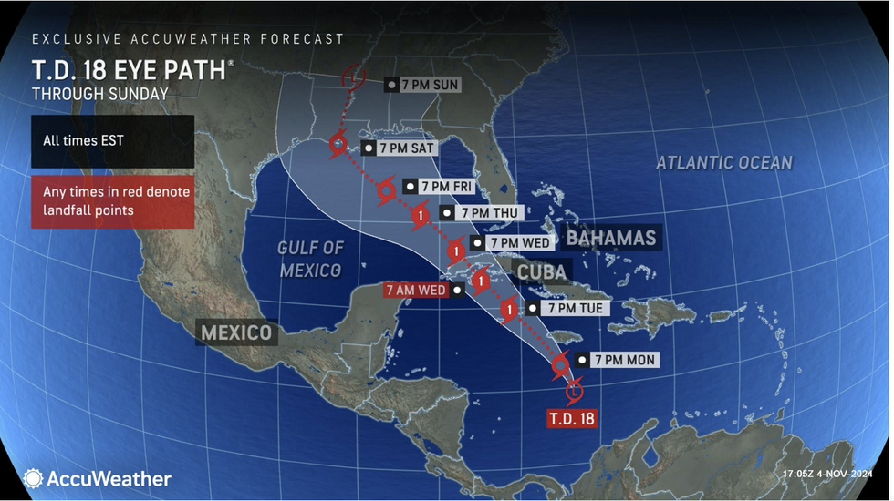
 Hurricane Rafael storm pathAccuWeather
The NOAA said: “The Storm Prediction Centre has Critical Fire Conditions highlighted for southern California with an extreme area in the vicinity of Santa Clarita.
“Strong wind gusts with lower moisture will increase the risk for wildfires over the next few days, and red flag warnings are in effect for portions of coastal and interior California.”
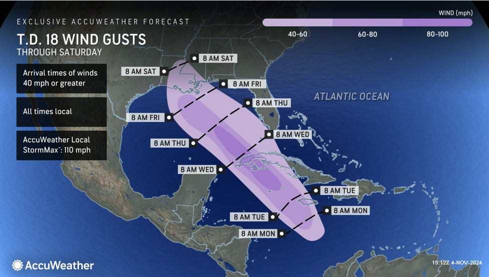
Meanwhile, eastern coasts are braced for the next tropical storm battering as Hurricane Rafael bulldozes through Gulf waters.
While the Caribbean is in the firing line for the worst of the impact, US coastal states are once again on alert.
Current forecasts show the storm blowing either further west across the Gulf of Mexico or north into Florida.
 Hurricane Rafael: wind gustsAccuWeather
AccuWeather meteorologist Jon Porter said: “Rafael is going to encounter a fork in the road on Thursday, and once the storm passes over Cuba and reaches the Gulf of Mexico, it will either track to the west or be drawn to the north.
“A westward track would greatly reduce the risk of US impacts. But if Rafael continues moving to the northwest, we could see a landfall between Louisiana to Florida.”
The stark contrast between east and west will be driven by a dip in the jet stream and a trailing weather front cleaving the nation.
Winter will arrive early to the west this week while to the east, the tropical storm season rages on abated.
Jim Dale, US meteorologist for British Weather Services and co-author of ‘Surviving Extreme Weather’, said: “Some of the western states are going to feel the chill this week with temperatures down to below freezing in parts.
“There will be a risk of frosts and snow over higher ground as low-pressure systems come in from the west.
“Across the Rockies, a cold plume will bring the risk of heavier snow.”


