


A bitter plunge is about to send temperatures into freefall as the US braces for anything from ‘hurricanes to snow’.
Eastern states will get an early taste of winter this week as a ‘big pattern change’ hits the country.
While southern and western America continue to bake in 110F-plus heat, cold air from the north will smother the east.
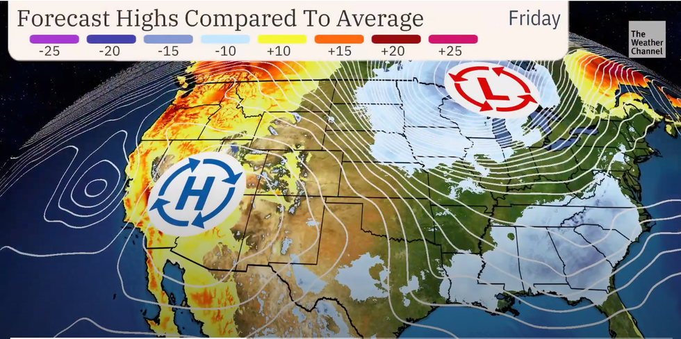
Weather Channel meteorologist Robb Ellis said: “Get ready for a big pattern change coming to most of the US later this week as high pressure builds in the west and a low-pressure trough sinks to the east.
“This means it will be cooler in the east and much warmer in the west, and these temperatures in the east as we get to the end of the week could be in the 60Fs, below average for much of the Midwest and the southeast.
“Most of the east coast is going to see temperatures take a tumble, but meanwhile the east is baking in triple digits from Phoenix to Vegas, Sacramento and all the way up to Portland.”
 Low pressure to the east brings the cold down | THE WEATHER CHANNEL
The eastern chill will come with the risk of heavy rain, he warned, with New York, Washington DC, Chicago, Florida and coastal regions in the firing line.
He said: “Along with that cooler air in the east also comes the chance of rain, meanwhile in the west, temperatures are high and the forecast is dry.”
A sizzling heat dome has kept thermometers in Phoenix above 100F for 100 days – a record according to the Phoenix weather service (NWS).
It beats the previous record of 76 days set in 1993 with no end in sight to the searing temperatures.
A dome of high pressure keeping storms and rainfall over the region at bay has largely driven the heat, experts say.
Extreme heat through the coming days in the west has triggered a raft of National Weather Service (NOAA) warnings.
Extreme heat through the coming days in the west has triggered a raft of National Weather Service (NOAA) warnings
|THE WEATHER CHANNEL
A spokesman said: “Highs range from the upper 100Fs to mid-110Fs in the Desert Southwest, the mid-90s to low 100s for southern and central California, and the mid-90s to low 100s for portions of the Pacific Northwest.
“Widespread heat-related warnings and advisories are in place as the threat for heat-related illness and impacts will increase, especially on Thursday.
“This heat will be dangerous to anyone without effective air conditioning or sufficient hydration.”
Colliding hot and cold air masses threaten storms at the boundary this week with even the risk of tornadoes.
A plume of humidity from the Gulf of Mexico will drive deep atmospheric instability, forecasters warn.
Jim Dale, US meteorologist for British Weather Services and co-author of ‘Surviving Extreme Weather’, said: “We are seeing record temperatures in parts of the US after weeks of very hot weather under the same heat dome.
“The start of September doesn’t appear to bring any change to western regions, with extreme heat set to continue.
“Elsewhere, there is the risk of storms and heavy rain, and in this mix, there will be tornadoes to watch out for.”
The coming weeks could bring major changes including wind, rain, hurricanes and snow, experts warn.
Weather Channel meteorologist Linda Lam said: “September is typically a month of transition from summer to fall, with weather ranging from hurricanes to snow.”