


A 700-mile ‘cold pool’ left in the wake of a ruthless winter cyclone threatens to unleash a crippling ‘ice storm’ across parts of the US.
Holidaymakers returning home after Christmas are warned travel in the worst-hit regions will be difficult to ‘near impossible’.
A huge storm battering America is continuing its frenzied journey since the start of the week from the west coast to eastern states.
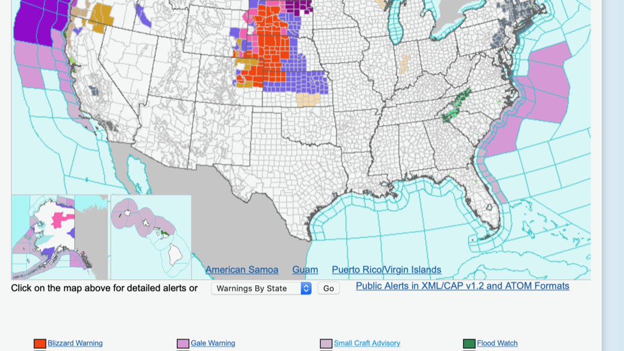
The National Weather Service (NOAA) has numerous severe weather alerts in force for the run-up to New Year.
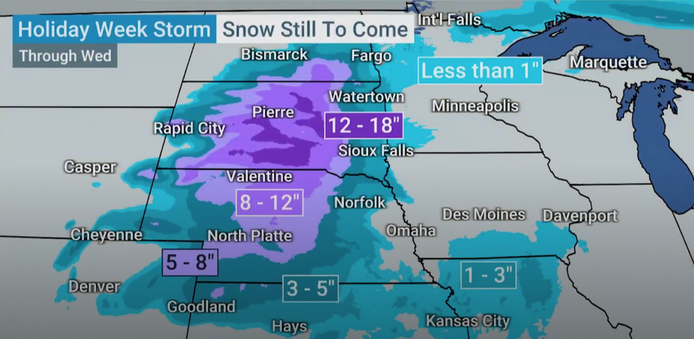
Snow is yet to come in the US
|THE WEATHER CHANNEL
In the firing line for the worst of the mid-week onslaught will be Kansas, Nebraska, North and South Dakota, Colorado and Wyoming.
North Dakota is on alert for freezing temperatures to glaze the swathes of the state with a lethal inch-thick sheet of ice.
Elsewhere, warnings are in force for heavy snow, blizzards, high winds and torrential rain as the storm moves through.
Jim Dale, US weather correspondent and meteorologist for British Weather Services, said: “We are still seeing the impacts from a front moving from the west of the United States across to the east through the week, and with this there is going to be a lot of rain and snow.
“By the middle of the week, the storm will have moved into the central zone of the country, and in its wake, a large cold pool of air will be pulled down from Canada and the north.
“This will bring the risk of further snow, and ice where temperatures fall below zero.”
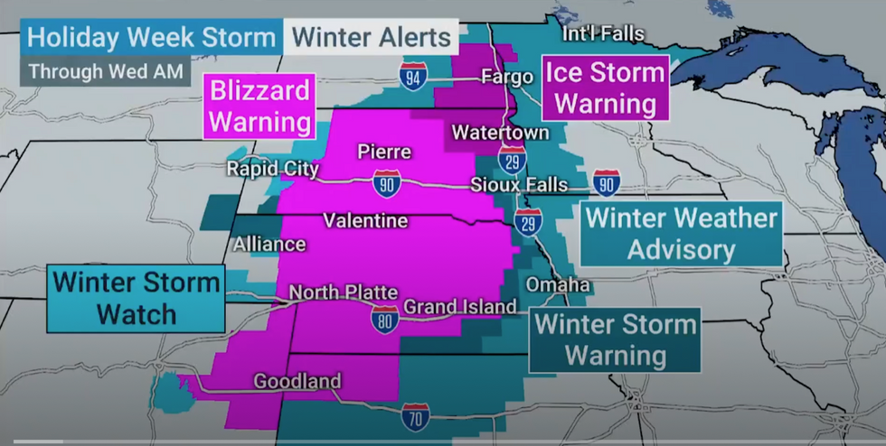
Storm alerts are in force
|THE WEATHER CHANNEL
Strangely, warmer air from the tropics will bring above average temperatures to southern states later in the week, he added.
Central regions will bear the brunt of the storm through the middle of the week before it tracks eastwards.
People returning home after the Christmas break are warned to take extra care and allow for delays.
The Weather Channel’s Time Harris said: “Through Christmas, parts of the South, central US and West could have travel issues, mainly from rain.
“The Northeast, however, could see worsening conditions in the days after Christmas.”
A Weather Channel meteorologist added: “We’ve got an ice-storm warning from Fargo to Watertown, and this is a combination of wind whipping around some of the snow that may be either falling or settled.
“This could reduce visibility down to under a quarter of a mile.”
The NOAA has several advisories in force for the coming days as the storm moves through central US states.
Eastern America, including the Great Lakes, are on alert for thunderstorms and heavy rain ahead of New Year.
Another storm system is forecast to charge in from the west unleashing more misery, according to The US National Oceanic and Atmospheric Administration.
A spokesman said: “A significant winter storm with heavy snow, blizzard conditions, and potentially damaging icing continues across portions of the north-central US through early Wednesday.
“There is a high chance that storm total snowfall will exceed a foot for areas of south-central South Dakota and north-central Nebraska.
“The combination of heavy snow rates and white-out conditions will make travel difficult to impossible, and a significant freezing rain event also continues from portions of northern/eastern South Dakota into southern/eastern North Dakota.”