US weather forecast: Millions of Americans warned 'leave home IMMEDIATELY' as Hurricane Francine to strike
'Hurricane Francine' is on a 65mph collision course with the south coast
THE WEATHER CHANNEL


Millions of Americans are urged to prepare to ‘leave their homes immediately’ as the nation braces for Hurricane Francine.
The sixth major storm of the season is on a 65mph collision course with the south coast, feeding off tropical Gulf waters.
Torrential downpours have sparked alerts for up to a foot of rainwater while a 10-foot storm surge threaten widespread flooding.
The US National Hurricane Centre (NOAA) has issued a red hurricane warning across southern coasts.
A spokesman said: “Leave immediately if evacuation orders are given for your area to avoid being cut off from emergency services or needlessly risk lives.
“The tropical system and disturbed weather associated with the front will bring threats for heavy rainfall, flash flooding, and strong winds to parts of the Gulf Coast through the middle of the week.
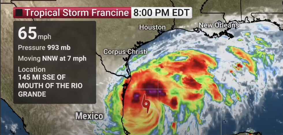 'Hurricane Francine' is on a 65mph collision course with the south coastTHE WEATHER CHANNEL
“There is also an increasing likelihood of life-threatening storm surge inundation for portions of the Upper Texas and Louisiana coastlines.”
Francine follows Ernesto which struck almost a month ago, tracking Alberto, Beryl, Chris and Debby.
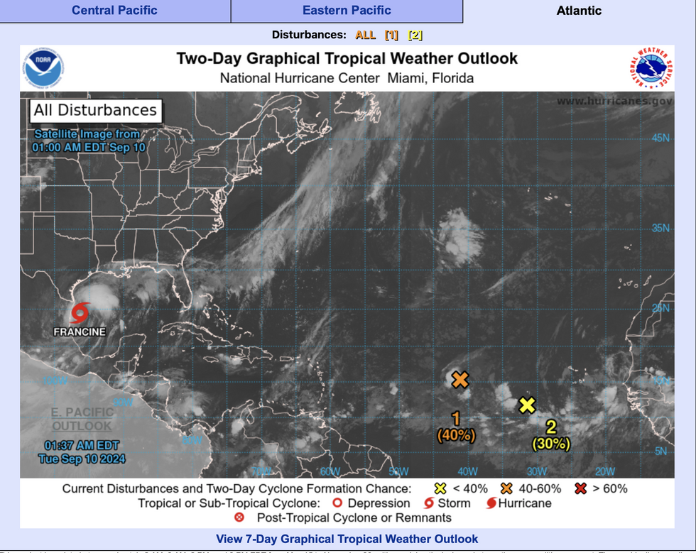
The Atlantic has suddenly ‘sprung to life’ after a relatively quiet September ahead of what is tipped to be a freakishly active hurricane season.
AccuWeather meteorologist Alyssa Glenny said: “After an eerily quiet stretch in August and the first week of September, tropical activity in the Atlantic has ramped back up again.
“Francine is expected to maintain or slowly strengthen early this week as it drifts northward, thanks to the abnormally warm waters of the Gulf of Mexico.
“One of the main concerns with this storm is that it is forecast to move into an area already impacted by heavy rain and flooding from a separate tropical rainstorm this past week.
The Atlantic has suddenly ‘sprung to life’ after a relatively quiet September ahead of what is tipped to be a freakishly active hurricane season
NOAA
“The ground across far eastern Texas and into Louisiana is already saturated, so it would not take much rain to cause flooding across these areas.”
Francine will reach peak strength ahead of the weekend, driving hurricane-force winds and ‘hazardous’ sea conditions.
Those in her path are warned of ‘considerable’ damage to buildings, snapping trees, and impassable roads.
A huge storm surge will drive dangerous rip currents as authorities warn to be ready to evacuate at short notice.
Meteorologists are keeping watch on an eerie ‘embryonic eye’ at Francine’s centre – a sign she could turn into a monster.
A Weather Channel spokesman said: “Francine is developing a core of thunderstorms, an embryonic eye, a sign of its strengthening according to microwave satellite imagery.
“Francine is forecast to continue to strengthen before it makes landfall as a hurricane somewhere along the Louisiana coast later Wednesday.
“It is soon expected to track over a pool of very warm Gulf water that would help it intensify.”
As the hurricane season reaches its peak, a further two tropical disturbances have been spotted in the Atlantic.
Both have the potential, after Francine, to head towards America as tropical storms or even hurricanes.
Jim Dale, US meteorologist for British Weather Services and co-author of ‘Surviving Extreme Weather’, said: “We are waiting for hurricane season to kick off, and while it has been quiet, we could see an increase in activity over the coming weeks.
“There is the potential for an active hurricane season this year.”


