


America is facing an early taste of winter as the tail end of Hurricane Lee brings a plume of Arctic air across parts of the country.
While Canada will be in the firing line for the chilly blast this week, a scattering of snow could dust high ground of northern US States.
Temperatures are forecast to plunge close to freezing around the Great Lakes and the Upper Midwest, forecasters warn.
It comes in the wake of Hurricane Lee which swiped the east coast of the US this weekend before making landfall over Nova Scotia.
A separate thrust from the Atlantic this will see the mercury nosedive across the west coast as the US is warned to wrap up for a bitter start to autumn.
Jim Dale, US weather correspondent and meteorologist for British Weather Services, said: “We are looking at the Great Lakes and north of the Great Lakes for the arrival of some snow this week, and possibly a touch over hills into the United States.
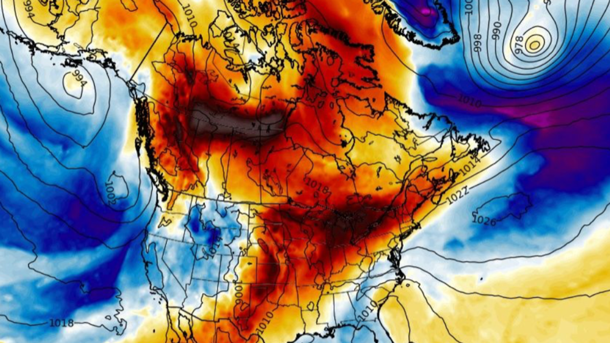
Cold air will send freezing temperatures to US states
|WX Charts
“This is an effect of Lee as it pulls away and drags Arctic air southwards across the Midwest of the country making it turn significantly colder in parts.
“It is going to be a taste of the arrival of autumn.”
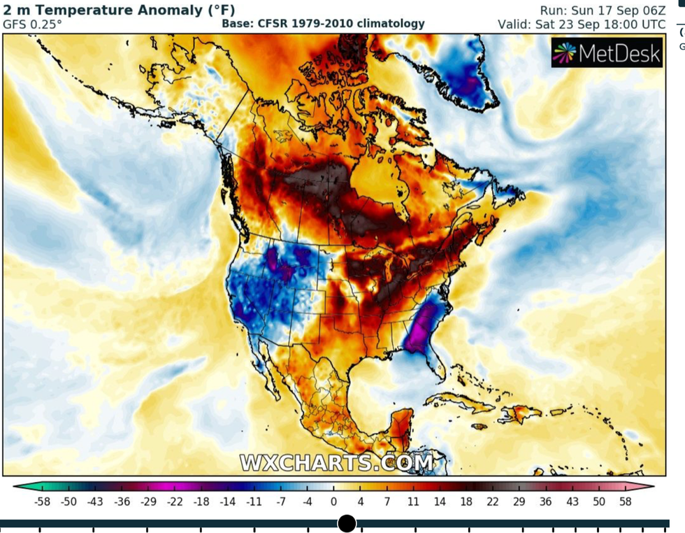
Cold pools of Polar air will straddle the country while strangely, southern states bake in a 40C heatwave.
Thermometers will continue to fall in the run up to mid-week around Chicago and to the east, and Washington and California to the west.
Bizarre temperatures triggered by competing air masses will bring an unstable atmosphere and thunderstorms to parts, Mr Dale added.
He said: “In between these two plunges of cold air there is going to be a surge of heat in between, and this is going to spark some thunderstorms.
“As Lee moves off towards Greenland, it pulls Arctic air down, so northern States are going to start to notice the change of the seasons.
“There is going to be a huge divide between the west central portion of the US and the northeast in terms of temperatures.”
Hurricane Lee was downgraded from a hurricane to a post-tropical cyclone at the weekend after hitting Western Nova Scotia.
The storm whipped up winds of 70mph as it churned around 50 miles from Eastport, Maine, and 135 miles from Halifax, Nova Scotia.
In its wake, another tropical storm, Margo, is hurtling through the Atlantic followed closely by yet another, Nigel, which formed at the weekend.
Margo is forecast to take an easterly u-turn missing the states while Nigel is eyeing up a similar path to Lee.
A spokesman for the US National Hurricane Centre (NOAA) said: “As Margot continues to weaken, this mid-level ridging should rebuild, allowing Nigel to bend a bit more north-westward in the 24–48-hour time frame.
“By the middle of [this] week, the global model guidance is in good agreement that Nigel should recurve to the northeast as it gets picked up by a mid-latitude trough ejecting off the eastern US coastline.”
A spokesman for The Weather Channel said eastern coasts would stay at risk of strong rip currents as Lee heads east away from the State.