


A HUGE -15C ‘winter storm’ is about to rip through northern America dumping inches of snow as parts of the United States brace for a bitter ‘shock to the system’.
Arctic air will spill across Canada into the US through the coming days amid warnings to ‘get ready’ for plunging temperatures, ice and a five-inch winter blanket.
The cold blast will be driven by northerly storm systems circling US states and dragging in plumes of cold air from the North Pole.
Jim Dale, US weather correspondent and senior meteorologist for British Weather Services, said: “This is going to be a shock to the system, certainly after the warmer weather we have seen over the past few weeks across southern states.
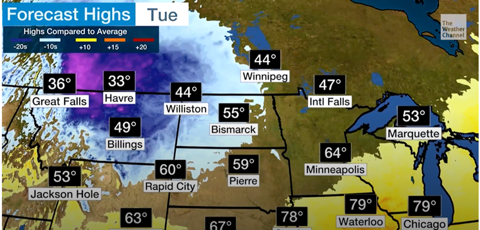
Shivering daytime highs as snow hits
Weather Channel
“The cold is coming in of the back of north-eastern and northerly winds, and the nor’easter storm system to the northeast of the US.
“It will come in through Canada, New England, Maine, and New York.
“As well as feeling much colder, there is going to be a risk of snow over the hills and mountains.”
Parts of the country could see up to five inches of snow through the week, particularly north-western states.
Meanwhile, temperatures across Washington, Montana, Oregon, Idaho, Wyoming, Nevada, Utah, Colorado, the Dakotas, Nebraska and New England will nosedive.
Thermometers could hit -15C in higher exposed regions across Utah, Colorado and Wyoming, according to some weather charts.
Cyclonic low pressure will whip up a winter storm bringing the coldest blast of the season so far.
Weather Channel meteorologist Orelon Sidney said: “The first winter storm of the season is going to roll into the Rockies and northern plains.
“First of all, we start off with just a little shot of some cold air, some rain and possibly a little bit of wintry mix as we get to the middle of the week, but then next weekend the bottom drops out.
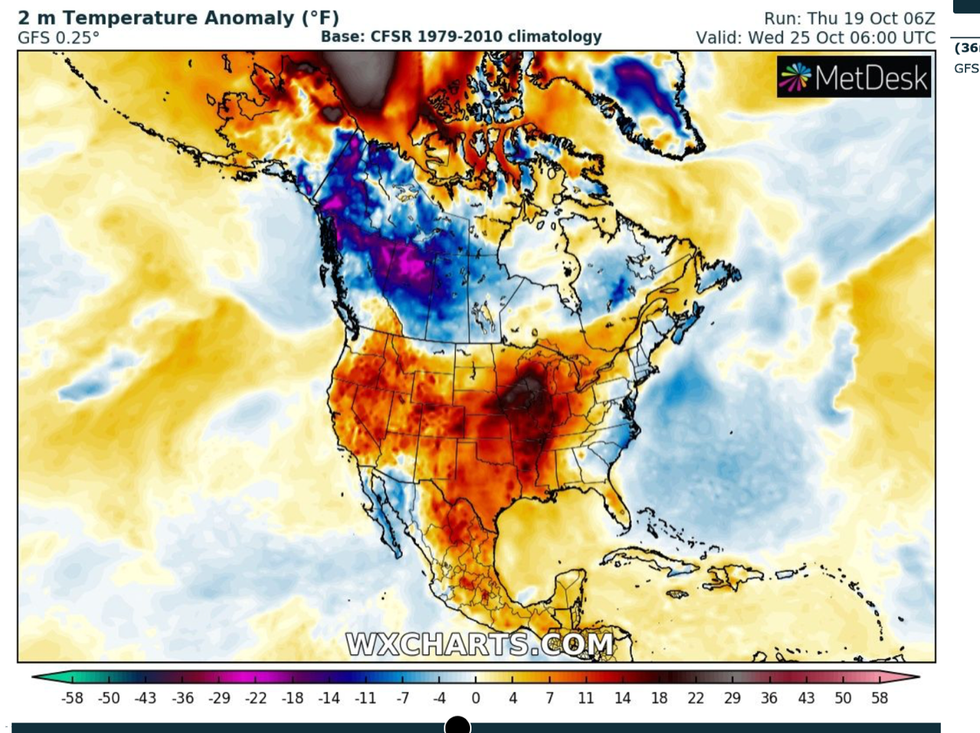
Cold floods down from the north
WX Charts
“We will see a possibility of ice from the Dakotas all the way down to Colorado.
“Get ready for it.”
The heaviest snowfall is likely to be across central Montana, the Rockies and Wyoming, she warned.
Here, three to five inches could blanket the region as daytime temperatures struggle to get much above freezing, she added.
She said: “So enjoy your weekend.
“Because by Monday, the 30Fs and 40Fs will advance across Montana into the Dakotas and then southward into Wyoming and parts of Nebraska.
“It is getting colder across the plains.”
Meanwhile, the remains of Hurricane Norma threaten to soak central US states with a mid-week deluge.
Low pressure tracking in from the southwest will be turbocharged by the ex-hurricane which will sweep a band of moisture up from the Gulf of Mexico.
Weather Channel meteorologist Jonathan Belles said: “An upper-level low-pressure system that's digging into the Southwest early this week will help pull Norma's moisture, as well as moisture from the Gulf of Mexico, northward through the Plains and upper Midwest.
“And this may not be the end of the wetter weather.
“Computer model guidance suggests that disturbed weather could continue into the following week, but those details will need to be figured out in the coming days.”
