


A ‘fast-moving’ snowstorm threatens to charge across the United States as plunging temperatures drive sheets of ‘radiation ice’.
While southern states roast in near record heat, northern states face sub-zero winds and an early taste of winter.
An ‘Alberta Clipper’ storm will plough eastwards from Alberta, in Canada, keeping New England, Pennsylvania, New York, Michigan, Wisconsin and surrounding regions in the freezer into the weekend.
Meanwhile, plunging temperatures will glaze swathes of the region under sheets of ‘radiation ice’ – formed when ground heat radiates under clear skies causing moisture to freeze.
Jim Dale, social commentator and senior meteorologist for British Weather Services, said: “Ice is going to be the issue as this cold front moves through, and this is primarily the result of heat radiation in areas where there is ground moisture.
“The cold air will move through quite quickly, with the risk of snow across the northeast lasting through the week and into the weekend.”
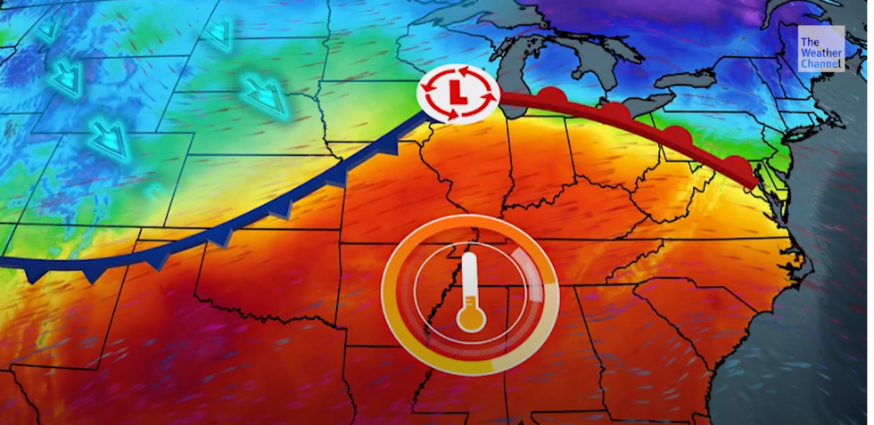
Cold air pushes down the heat across America
The Weather Channel
Moist air wafting from the Great Lakes will drive the mini-freeze with the heaviest snowfall likely in surrounding regions, he added.
He said: “The main snow event will be north of the Great Lakes, although there is expected to be some mountain snow in the mix.
“After the weekend, we are looking more at rain, so that will be a watching brief into the new week.”
It comes as a surge of heat from Mexico drives possible record temperatures across the southern US.
New Mexico, Arizona, Texas, Louisiana and the southern flank of the country are forecast temperatures of 30C.
Hot air clashing with cold air to the south threatens to ignite a spate of vicious thunderstorms, experts warn.
The cold plunge will be driven by a ‘disturbed’ weather feature laden with precipitation speeding eastwards.
The ‘impactful’ ‘Alberta Clipper’ storm will stir up a cocktail of snow, rain and freezing rain, according to The Weather Channel.
Meteorologist Ari Sarsalari said: “A weaker little storm is going to be impactful in some ways.
“It is going to move across the northern tier of the US through the middle part of the week.
“This is one of those Alberta Clipper type systems, and they generally move from west to east and they usually stay pretty weak, so it is a quick little dusting of snow.
“It is usually when the storms take more of a dive down towards the south and they tend to get stronger.”
New York will be at risk of ice through the latter part of the week, while freezing rain could hit New Hampshire and Vermont, he said.
Some regions could see up to three inches of snow settled over the coming days, he warned.
AccuWeather meteorologist Brandon Buckingham added: “The setup from Wednesday night to Thursday morning will likely bring freezing rain as the primary form of precipitation in the Adirondacks, Catskills, Berkshires and southern parts of the Green and White Mountains,
“These same areas may have a build-up of 0.10 to 0.25 of an inch of ice on trees and other exposed surfaces."
