US snow forecast: Winter Storm Qadir to bring heaviest snow for three years to America
US snow forecast America to be hit with heaviest snowfall in three years
The US national weather service has ‘extreme severity’ warnings in force for up to four feet of snow
Don't Miss
Most Read
Trending on GB News
A ‘major’ winter storm threatens the ‘heaviest snow in three years’ as parts of the US brace for a three-day Polar deluge.
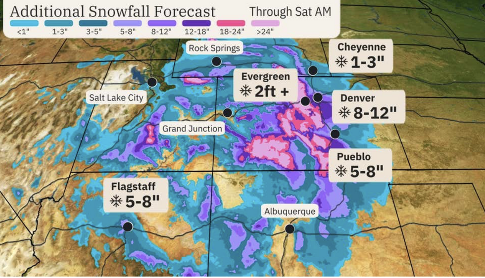
The US national weather service has ‘extreme severity’ warnings in force for up to four feet of snow in Colorado, Wyoming, Utah, and Montana ahead of Winter Storm Qadir.
Most at risk are the foothills and mountains of Denver and the southern Palma Divide, although several inches could smother northern Arizona, northern New Mexico, Utah and Wyoming.
Although March snowfall is not uncommon across the Rockies and the Front Range, Denver is facing the heaviest in three years.
Qadir will start flexing its muscles this evening with heavy wintry downpours to hammer warning areas into the start of the weekend.
Weather Channel meteorologist Chris Dolce said: “This system has been named by the Weather Channel ‘Winter Storm Qadir’, and Denver could see its heaviest snowstorm in three years.

Additional snowfall across parts of America
The Weather Channel
“March is one of the snowiest months of the year for parts of this region, but in the foothills and Palmer Divide of Colorado, there could be multiple feet of snow.
“This major winter storm will impact the Rockies and the Front Range, including Denver, and a winter storm warning is now in effect for the Denver metro area Wednesday evening through Friday Morning.”
People travelling in the area are urged to rethink plans with heavy snow threatening ‘significant disruption’.
The storm will move in from the west on Wednesday evening hitting Utah, Arizona, Wyoming, Colorado and new Mexico.
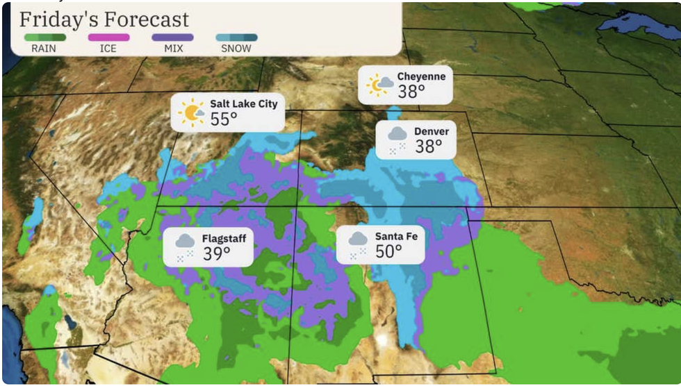
The initial risk is from snow, although by the end of the week the area will battle a mix of snow, rain and ice.
The NOAA’s Winter Storm Severity index has been ramped to ‘extreme’ in parts of Colorado, and between ‘moderate’ and ‘major’ across the rest of the state.
Experts have warned Qadir threatens to unleash the worst assault since the 2021 Fort Range blizzard.
Changes in pressure patterns high in the atmosphere causing waves or ‘troughs’ of pressure differences will drive the storm.

Colorado, Wyoming, Utah, and Montana will all face snow
The Weather Channel
A NOAA spokesperson said: “The interaction of the upper trough with the intensifying low pressure system will begin to organize and focus an area of moderate to heavy snow over central Colorado by early on Thursday.
“By Thursday morning, snow could be falling in earnest over the mountainous
terrain into the Front Range and nearby High Plains of central Colorado.”
The storm will gather strength through the next 24 hours before offloading a deluge into the weekend.
Intense snowfall with little warning late in the season could catch people unawares, experts warn.
Jim Dale, US weather correspondent and meteorologist for British Weather Services, said: “People should be very careful through the next three days as the storm has the potential to bring dangerous conditions.
“The cold air is going to be Polar in origin and will bring a lot of snow which though not unheard of, is unusual this late in the season.
“There is the potential for blizzards and severe disruption, especially over high ground.”


