US hurricane warning: 'Tropical threat' to spark glut of freakishly powerful storms
A tropical disturbance, as yet unlikely to directly affect the US, is making waves in the Caribbean
Don't Miss
Most Read
Trending on GB News
A ‘tropical threat’ in the Caribbean will kick start a ‘hair-raising’ hurricane season amid warnings of a glut of freakishly powerful storms.
Unusually warm ocean temperatures with El Nino transitioning to La Nina in the eastern Pacific will provide the perfect ingredients to fuel the assault.
Hurricanes this year threaten to be not only more powerful, but more likely to make landfall, experts warn.
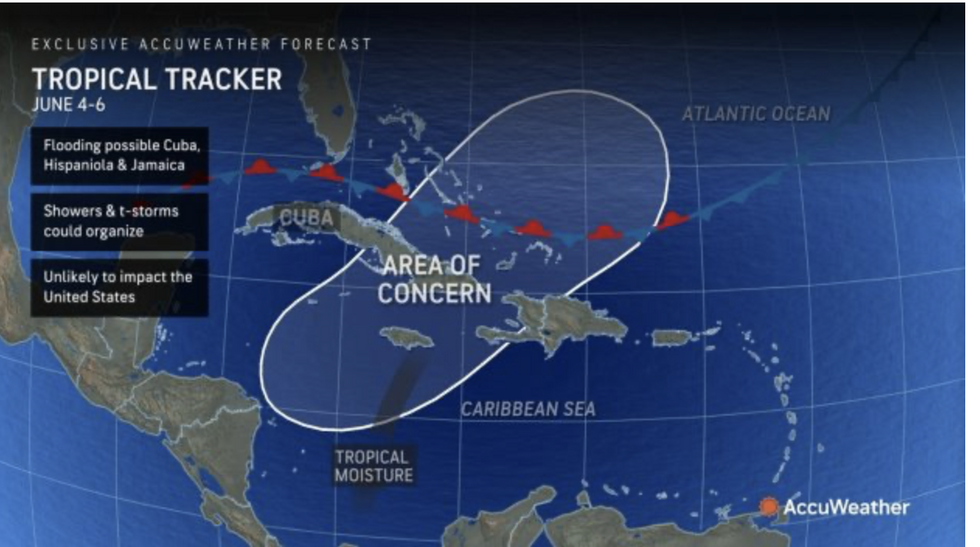
It comes as a tropical disturbance, as yet unlikely to directly affect the US, makes waves in the Caribbean.
AccuWeather lead hurricane forecaster Alex DaSilva said: “The tropics have the potential to come alive during the first week of June.
“A surge of tropical moisture will stream north through the central Caribbean.
 A tropical disturbance, as yet unlikely to directly affect the US, is making waves in the CaribbeanACUWEATHER
“Atmospheric conditions will gradually become more favourable for development over the next 10 days.”
A spokesman added: “A disturbance, known as a tropical wave, has been interacting with moisture and storms in the Caribbean.
“Forecasters are monitoring an "area of concern" for next week spanning from the northern Caribbean.
“However, the early tropical threat is not expected to bring direct impacts to the US.”
June marks the start of the hurricane season in the Atlantic basin with this year expected to be unusually active.
The tropical Pacific is coming out of an unusually strong El Nino–warming of the sea around South America.

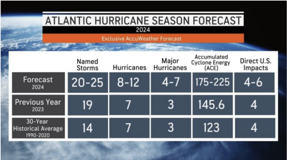
Atlantic hurricane season forecast
ACUWEATHER
A rapid cooling could trigger El Nino’s counterpart, La Nina, which brings a gamut of weather impacts including a potentially ‘explosive’ hurricane season.
An AccuWeather spokesman said: “Our forecast released in March warned of an ‘explosive’ hurricane season in the Atlantic basin.
“Our expert meteorologists and long-range forecasters predict 20 to 25 named storms this season.”
Hurricanes take energy from moist, warm ocean waters, but quickly die when they hit land.
Higher sea temperatures, though, could supercharge storms moving across the Atlantic giving them strength to make landfall.
Jim Dale, US weather correspondent for British Weather Services, said: “Hurricanes get their strength from the tropical ocean waters, but when they reach cooler waters or land, they lose this energy and die.
“They can cause some damage in the process as they move across US states close to the coast.
“But if they are more powerful, which they could well be with ocean temperatures as high as they are, then it stands to reason that they would be more likely to make it to land.”
The National Weather Service (NOAA) predicts between 17 and 24 names storms this season and between eight and 13 hurricanes.
Weather Channel meteorologist Jonathan Erdman said: “The NOAA has just thrown its bet in for how many named storms and hurricanes we’ll see this hurricane season.
“This very active forecast is in line with other forecasting groups, including The Weather Channel.
“The hair-raising outlook comes with a double-whammy of support, record warm water temperatures in the tropics, and El Nino departing in the rear-view mirror.”


