


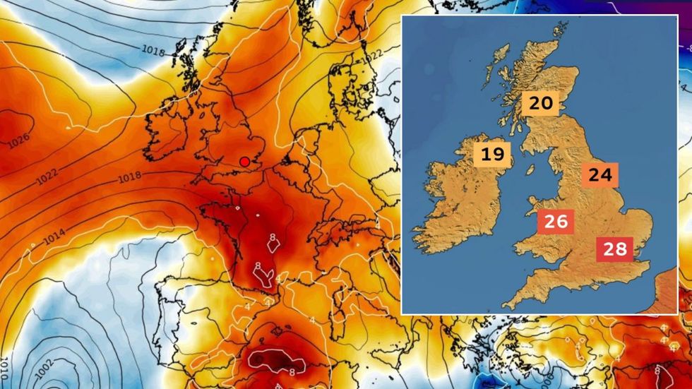
A 28C mini heatwave set to bake Britain will be the strange product of a northerly Arctic wind cooked under a high-pressure heat dome.
Despite reports of African and Spanish plumes, hot weather this week will arrive from chilly Scandinavia.
Air will sweep down from the Arctic circle and into a dome of high pressure building over the UK.
This high will cause Scandinavian winds to heat as air falls in the atmosphere, pushing temperatures into the high 20Cs.
A 28C mini heatwave set to bake Britain will be the strange product of a northerly Arctic wind cooked under a high-pressure heat dome
WXCHARTS/ Met Office
Though not unheard of, the phenomenon is unusual with hot weather at this time of year typically arriving from the south.
Met Office meteorologist Honor Criswick said: “We tend to talk about hot air coming from the south, or a warm plume coming perhaps all the way up from Africa, creating heatwave conditions.
“But what we are seeing is something slightly different, and our air is coming all the way from Scandinavia, so it is not a warm plume from the south.
“What is happening is that as the air moves towards the UK, it is moving into high pressure and high pressure, and areas of high pressure has air descending and as that moves downwards it tends to warm up, and we are having that over a few consecutive days.
“Temperatures are increasing day by day, but what is interesting is where our air is coming from.”
LATEST DEVELOPMENTS:
Fine, dry weather during spring and summer frequently follows a switch from low pressure to high pressure.
Otherwise known as ‘anticyclonic’, the pattern change leads to clear skies and depending on the position of the high, rapidly rising temperatures.
High pressure from the south often pushes up from the tropical Azores Islands, near Portugal, and can trigger extreme summer heatwaves.
Unlike low pressure characterised by rising air circled by fast winds, high pressure involves air falling, or ‘subsiding’.
As it falls, the air compresses and warms, which is the driver behind the warm weather this week, despite the air’s source.
Jason Nicholls, lead international forecaster for AccuWeather, said: “High pressure will bring dry and warm weather across much of the UK until, at least, the middle of the week.
“There are some different forecasting outcomes for the end of the week, but temperatures will rise through the start of the week.
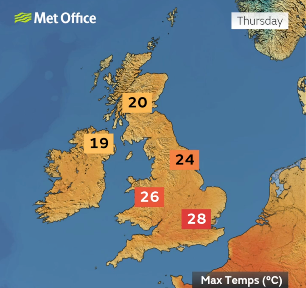
Air will sweep down from the Arctic circle and into a dome of high pressure building over the UK
Met Office
“A high-pressure ridge will build over northern Europe, and this could push temperatures around 10C warmer than the average for the time of year.
“We could see highs in London of around 21C compared to what is normal at this time of year which would be 14C.”
Soaring temperatures have prompted eager bookies to slash the odds on records this week tumbling.
Coral’s John Hill said: “With the mercury set to climb significantly next week, we have slashed the odds in half on the UK’s highest ever April temperature being broken.”
Jim Dale, meteorologist for British Weather Services and social commentator, said: “There is a chance that we could come close to the records this week as high pressure builds from the Azores.
“This is especially likely in the southeast.”
