


The Met Office has issued wind warnings spanning the length of Britain as stormy conditions are set to batter the country with gusts of up to 70mph.
Forecasters have warned of potential travel disruption, dangerous coastal conditions and possible power cuts as strong winds sweep across the nation.
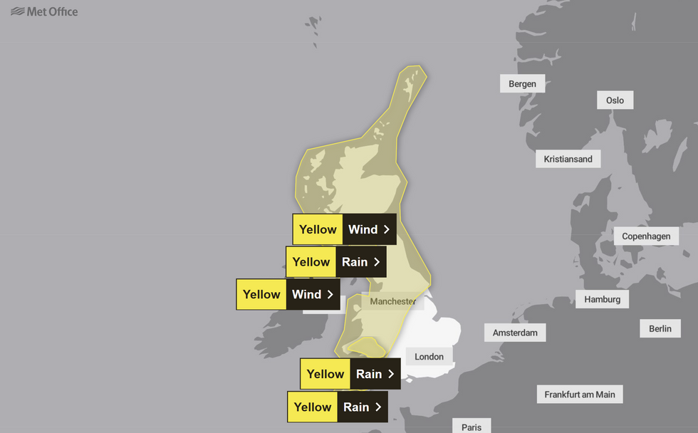
The warnings come as the UK transitions from recent below-average temperatures to milder conditions brought by air from the southwest. Exposed coastal areas in Wales and Scotland are expected to face the strongest impact, with widespread gusts of 60mph forecast within warning areas.
Three separate wind warnings have been issued across western Britain, covering south and west Wales, southwest Scotland, and eastern parts of Northern Ireland.

It comes after Storm Eowyn caused mass damage in January
PA/Met Office
Parts of Northern Ireland are forecast to experience gusts of 45-55mph, with counties Down and Antrim potentially seeing brief gusts of up to 65mph. Two additional rain warnings are in place for Scotland, where 30-40mm of rainfall is expected within six hours.
Higher ground in Scotland could see up to 70mm of rain by Friday evening, according to Met Office forecasts.
Met Office Deputy Chief Meteorologist Mike Silverstone said: "The weather will be turning milder for much of the country from Thursday, but this transition heralds the start of some potentially more impactful wind and rain."
"While Thursday will see blustery winds and rain for many, it's Friday when we could see more impacts, with warnings issued for wind and rain," he added.
LATEST DEVELOPMENTS
- US weather: Violent tornadoes to wreck havoc as relentless storms will plough into Arctic mega-freeze with blistering -45C North Pole winds
- Met Office issues rain and wind warnings in 3 major UK regions as 70mph gusts to hit Britain
- UK weather: Arctic gloom to give way to mid-teen heat surge as Britain’s winter woes set to end
 A bus drives around bins blown over by the winds from Storm Eowyn on Princes Street, EdinburghPA
He continued: "On Friday, south and west Wales, southwest Scotland and eastern parts of Northern Ireland will see the strongest winds, possibly around 70mph on exposed coasts and around 60mph more widely within the warning areas."
Saturday will provide a brief respite for many areas, with significantly reduced rainfall, though the southeast will see Friday's rain gradually clearing throughout the day. However, more unsettled conditions are set to return on Sunday as wet and windy weather sweeps eastward across the UK.
The Met Office has indicated that further weather warnings may be issued for Sunday once details become clearer.
Looking ahead to next week, the westerly weather pattern is expected to continue, bringing showers and longer spells of rain. Temperatures will return closer to average following several very mild days.
The weather warning is in place for Sunday
Met Office
Mike Silverstone explained the changing weather patterns: "The underlying factor in the shift in the UK's weather is our transition from a cold easterly regime to more of a westerly regime."
"While this pushes away the colder air that has been affecting us, it also reintroduces Atlantic weather systems and the potential for areas of low pressure to influence the UK's weather," he said.
"While Saturday should provide respite for many, Sunday will see more wet and windy weather sweep east across the UK. There's a potential for further warnings on Sunday as details are firmed up in the coming days."
