


The warmest weekend of the year so far will give way to a wintry dusting as the balmy weather falls to an Icelandic ice dome.
Britain will become the battle ground for tussling airflows bossed by a giant pressure bubble flexing its muscles over the Arctic circle.
After temperatures this weekend soar into the mid- to high teens, possibly the highest of the year, chilly gusts will bring a late taste of winter.
At the helm of the muddle is a giant high-pressure ‘anticyclone’ over Iceland, steering in northerly and easterly winds.

The warmest weekend of the year so far will give way to a wintry dusting as the balmy weather falls to an Icelandic ice dome
WXCHARTS/ Met Office
Met Office meteorologist Alex Burkill said: “High pressure towards Iceland looks like it is going to develop and looks like it will be quite a bit of a feature of our weather as we go through next week.
“By the time we get to Saturday we end up in a fairly broad warm sector with a warm front stalling across northern parts of the UK and a cold font trying to push its way north-eastwards as we go through the day.
“For many places this is going to be quite a clear warm sector, so there should be some decent bright if not sunny weather and pretty warm with temperatures in the mid-teens or even higher than that as the air comes in from the southeast.
“For many, Sunday brings a decent amount of sunshine and temperatures above average for the time of year.”
The outlook for next week depends on the exact mood of the Icelandic high, and whether it stays to the north or sinks south.
LATEST DEVELOPMENTS:
Either scenario would see the mild weekend sunshine give way to an early spring chill and a touch of sleet or snow.
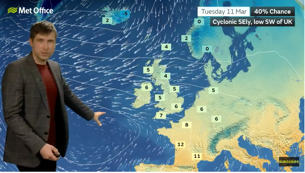
Burkill said: “We could see low pressure towards the southwest of the UK and high pressure towards the northwest of us, and if this comes off then we would get a bit of an easterly with temperatures dropping a little bit with some showers mixed in with this as well.
“The second most likely scenario has the high pressure dipping down and just to the west of the UK, and if this comes off we would get a bit of a northerly flow with temperatures dipping down a bit.
“There could be some showers with this, and there is a chance that these could bring something wintery, a bit of snow or a bit of sleet over higher ground of Scotland, but nothing too unusual for this stage in early spring.”
A southerly shift in the jet stream could bring easterly coastal ‘haar and fret’ fog for the start of next week, he added.
Britain will become the battle ground for tussling airflows bossed by a giant pressure bubble flexing its muscles over the Arctic circle
Met Office
The chilly snap will come as meteorologists pore over a more significant cold snap driven by a possible change in winds in the northern stratosphere.
A Sudden Stratospheric Warming (SSW) event later this month would bring the risk of more severe cold weather.
SSW was behind the notorious 2018 Beast from the East, which drove a savage cold spell through February, grinding swaths of the nation to a halt.
But an event on that scale this year is unlikely, experts say, with a weak SSW threatening a moderate risk of a chilly start to spring.
Jim Dale, meteorologist for British Weather Services, said: “It is not unusual to get a northerly air stream with the risk of frosts and snow at this time of year, and if we are going to get anything at all it will most likely affect northern England and Scotland.”
