


A strange weather phenomenon is set to hike UK temperatures up to unusual levels of warmth after last weekend's record levels subsided over the start of the week.
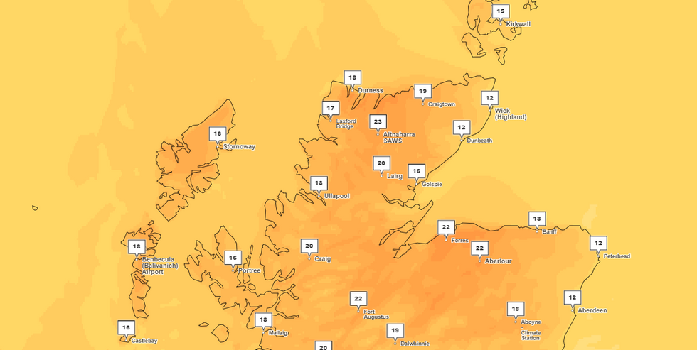
The Foehn effect, where air warms and dries as it passes across mountains, could see temperatures soar once more in parts of Northern Scotland later today.
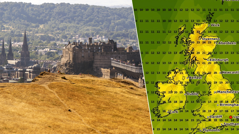
After the UK revelled in its hottest weekend so far this year, temperatures slipped back to the low teens this week.
Thermometers in the area could shoot past 24-25C, forecasters have said, in what would mark highs well past seasonal averages in the region.
The Foehn effect could see temperatures skyrocketing in Scotland (file photo)
WXCharts/PA
And across much of the UK in the days and weeks to come, temperatures are set to bounce back from a somewhat dour start to the week.
Though it's unlikely thermometers will pass the 20C mark in much of the UK, London, the Midlands and South-East England are predicted to join Scotland's north in heading for warmer climes.
This week, a blanket of hot weather will stretch from Kent to Peterborough, while cities including Manchester, Leeds and Liverpool should see 19C highs.
But the temperatures across more southerly parts of the UK won't be in place thanks to the strange weather effect heating up Northern Scotland.
MORE HEATWAVE NEWS:
The Foehn effect is set to cause unseasonable temperature spikes in Scotland
Met Office
The Foehn effect refers to how air on the downwind, or leeward side of a given mountain is warmer and drier than air on its other side.
When air is pushed up over a mountain, it cools and condenses to form clouds and rain - but when it then descends down the other side, the resulting lack of moisture means it warms up.
The effect can be found in mountain ranges the world over - and while there is no local name for the resulting heat in Scotland, the phenomenon is known as the Chinook in North America's Rocky Mountains, and the Zonda in South America's Andes.
US National Weather Service data shows a Foehn event in 1972 sent temperatures skyrocketing by a staggering 57C in the US state of Montana - from -48C to 9C.
And like in the Rockies and Andes, the UK's prevailing westerly wind means the Scottish Highlands tend to feel the Foehn effect at its strongest.
Just this January, a Foehn event in Achfary, Sutherland, prompted highs of 19.9C - the UK's highest temperature in January 2024.
The Met Office says the Foehn effect in Scotland "results in a marked contrast in weather conditions across the country with the west being subjected to wet weather, whilst the lower lying east enjoys the warmth and sunshine".
But any subsequent temperature increases can bring detrimental effects including avalanches, glacial melting, downstream flooding and wildfires.
