


Britain’s freezing gloom will end in a surge of westerly winds spiralling a dragon-shaped loop of the jet stream.
Bitter cold weather will gradually give way to milder winds with the weakening of a Scandinavian high-pressure dome nudging the UK.
But through the opening Atlantic gates will come outbreaks of sleet, snow and freezing rain.
The cold snap will ease slowly with temperatures rising around the middle of next week.
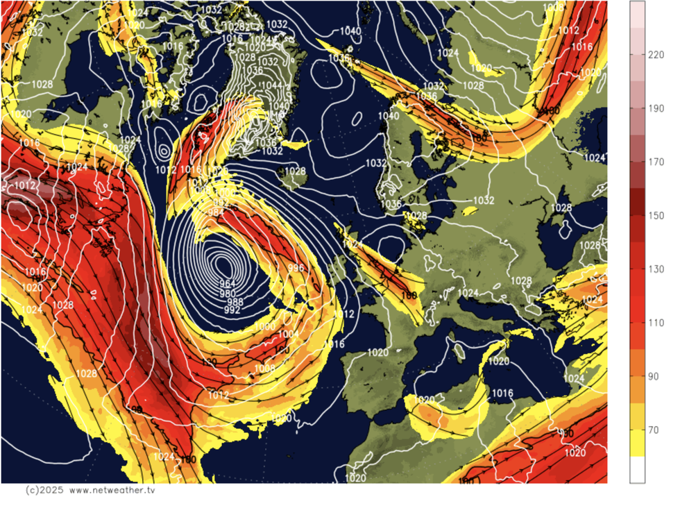
Britain’s freezing gloom will end in a surge of westerly winds spiralling a dragon-shaped loop of the jet stream
|Netweather
Met Office meteorologist Alex Burkill said: “For the next two weeks, a change to lower pressure seems the likely scenario.
“A westerly is likely to develop, and there is agreement that a transition from this easterly to a westerly is most likely around Tuesday or Wednesday next week.
“We are likely to see a change from an easterly to a westerly with high pressure being most dominant to low pressure taking a bit more control, but exactly when it happens and how strong it’s going to be, that is where we heed to film up the details.”
A ‘layer’ of warm air high above sea level – at 850hpa, around 1.5km – will move across the UK, although the ground will stay cold.
The set-up, revealed on meteorological ‘thickness charts’ showing temperature in layers through the atmosphere, will trigger freezing rain.
WEATHER LATEST:
Mild showers falling from the warmer level through Arctic air left over Britain will freeze on impact with the ground.
Burkill said: “We are also going to see the temperatures at the 850hpa layer rising, so we are going to see some warm air pushing in.
“As rain falls into the colder layer, just before it reaches the surface, it is going to become super-cooled and it is not going to freeze until it reaches the surface.
“That is where we have the risk of freezing rain, and there is the risk through next week of freezing rain mixed in with some sleet and snow at times as well.”
The change in weather will be driven in part by the jet stream, shifting to allow westerly low pressure to budge the Scandinavian high.
Models show the jet shaped like a rearing dragon, looping around an Atlantic cyclone laden with rain, sleet and snow.
Rainfall and the risk of snow through the middle of the month will be highest in Scotland and the northwest, experts warn.
While significant wintry showers are unlikely, disruption is possible prompting warnings to keep watch on Met Office warnings.
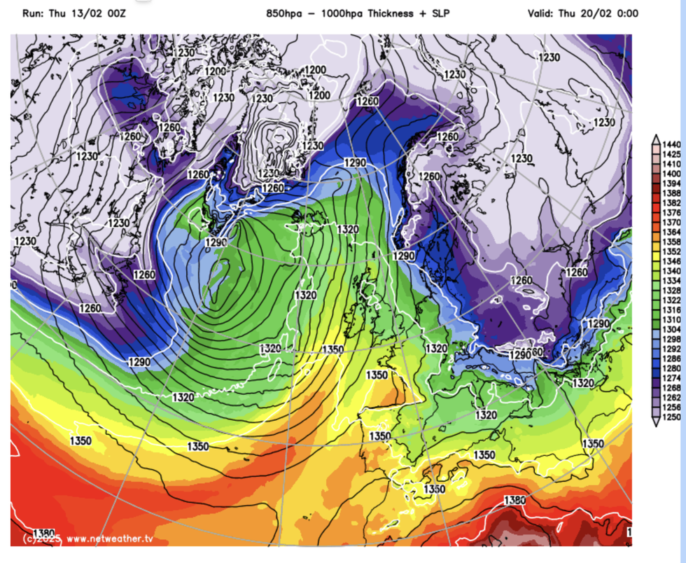
850hpa thickness chart shows warmer air sweeping in
|Netweather
Yo-yoing weather patterns will persist as Britain remains ‘sandwiched’ between low and high pressure, Burkill added.
He said: “As we go through the weekend and into next week, the rainfall totals will build up across some western parts.
“In terms of snowfall amounts, this could cause a little bit of disruption, so we may need to issue some warnings.
“If we run through next week, we are sticking with high pressure somewhere towards the east and low pressure somewhere towards the west and we are sandwiched in between.”
Temperatures in parts of the country could hit double figures next week as warm gusts sweep in from the southwest
The ‘dominant’ pattern of easterly cold from the Baltic will give way to a Continental flow, according to experts.
Jim Dale, meteorologist for British Weather Services and social commentator, said: “We have been dominated by eastern Europe and high pressure over Scandinavia, but there will be more of a flow from the Continent that will weaken this pattern and bring a change in the weather.
“We are going to keep the cold regime, but where you are lucky, you could see temperatures of 10C or 11C.”