UK weather forecast: 'Disruption of Polar vortex' set to plunge Britain into -10C deep freeze lasting for MONTHS
Winter temperatures could be extended well into the year
Don't Miss
Most Read
Trending on GB News
Spring could be put on hold by a ‘disruption of the Polar Vortex” threatening a -10C chiller into April.
A new Sudden Stratospheric Warming (SSW) event could plunge Britain into an extended period of cold weather, experts warn.
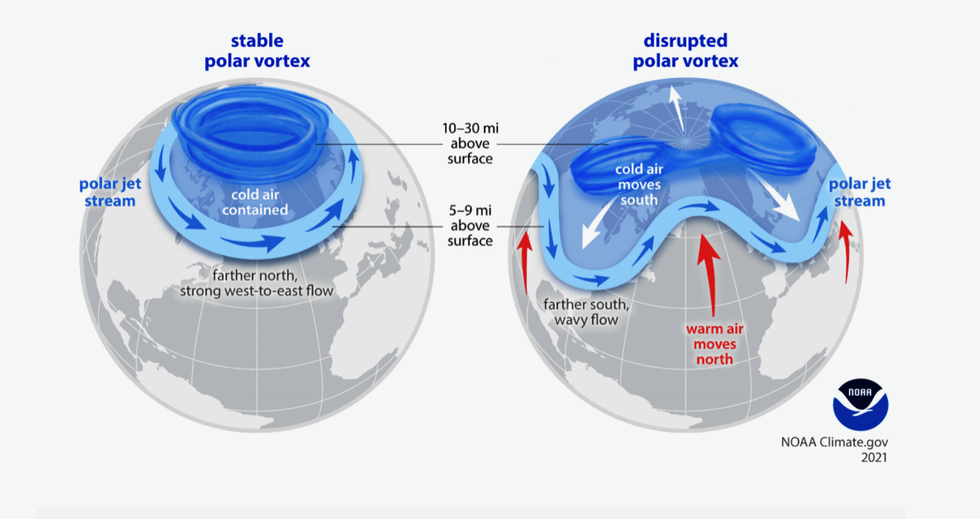
SSWs happen when winds high above the North Pole change direction forcing cold air southwards – the driver of the notorious 2018 Beast from the East.
While temperatures are expected to rise slightly after the weekend, the long-range outlook paints a bleaker picture.

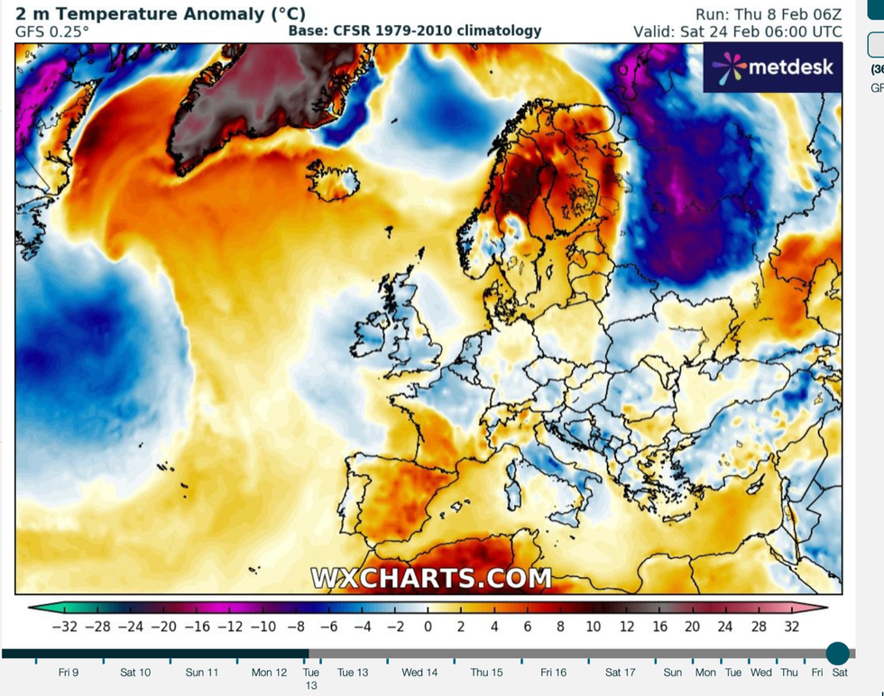
Colder temperatures are expected as the month progresses
WXCHARTS
James Madden, forecaster for Exacta Weather, said: “Another major Sudden Stratospheric Warming (SSW) is underway and likely to be confirmed in the coming days.
“It wouldn't be out of the question to see the coldest parts of England reaching as low as -10C or a little colder in the coldest spells of weather over the next four to six weeks.
“Providing the confirmation happens in the coming days as we expect, then we could see a return to much colder weather and the prospect of further snow events later next week and into the final part of February.”
A cold blast this late in the year would not pack the same punch as during the middle of winter, he said.
However, the change in meteorological patterns could put Britain at risk of snow into the start of Spring, he added.
It comes as temperatures across northern Britain once more take a nosedive with parts of the country under rafts of warnings for snow and ice.
Met Office snow alerts remain in force across Scotland until the end of the week as low pressure drags moisture from the Atlantic into cold air over the UK.
LATEST DEVELOPMENTS:

A new Sudden Stratospheric Warming (SSW) event could plunge Britain into an extended period of cold weather
US National Weather Service
A battle next week between high pressure to the east and low pressure to the west threatens further unsettled conditions.
High pressure will keep southern regions drier than the north, with showers widely easing by mid-week.
It could, though, whip an easterly wind down the North Sea Coast bringing the risk of harsh overnight frosts.
The outlook into the final week of February is for colder than average temperatures in the north and the east, with milder bursts further south.
A Met Office spokesman said: “Much of the UK will lie under the influence of predominantly dry conditions thanks to high pressure extending from mainland Europe, albeit with temperatures turning colder.
“However, milder, wetter weather from the Atlantic will always lie close by, with this encroaching from the west at times.”
A SSW event was confirmed at the end of last year, raising fears of cold weather through the start of 2024.
A second SSW is growing ever more likely, and could be more powerful that the first, according to some experts.
Andrej Flis, of Severe Weather Europe, said: “A Polar Vortex collapse event is now confirmed by the forecasts for mid-February.
“With a stratospheric warming event expected to develop, we currently see a rapid breakdown of the Polar Vortex.
“This upcoming event looks stronger than the first one.”
While the long-range outlooks suggest further colder weather to come, meteorologists insist forecasts are only ever certain within five to ten days.
However, opinions are starting to settle on the risk of further snow and bitter winds later this month.
Jim Dale, meteorologist for British Weather Services and social commentator, said: “There is every chance that this cold snap could be prolonged as a battle ground sets up between the Atlantic and the Arctic.”


