


A huge storm ‘wrapped up’ in the jet stream will smash the UK before a second attack is launched by a dying hurricane.
Britons are warned to make the most of the calm weather before the gates open to the fury of the Atlantic storm season.
A major low-pressure system will hit this weekend before the remains of Hurricane Kirk plough through next week.
Kirk, currently a 125-mph mega storm hurtling across the tropics, will weaken before its remains approach the UK on the jet stream.
Met Office meteorologist Aidan McGivern said: “Most likely, Kirk in some shape or form will come close to the UK either as an ex-hurricane or merging with another Atlantic low to bring mixed weather, wet and windy weather, but a typical depression we normally see in October.
“It is not going to be a hurricane, but we could experience the remnants of Kirk, or an ex-hurricane by the end of next week.”
 Kirk, currently a 125-mph mega storm hurtling across the tropics, will weaken before its remains approach the UK on the jet stream | ACCUWEATHER
The weather this weekend will be heavily driven by the jet stream – a fast-flowing ribbon of air in the atmosphere.
It will circle a massive cyclonic weather system over Britain causing it to stall and dump a three-day load.
While no storm names have yet been issued, it could be the first of the 2024/24 season – Ashley.
McGivern said: “There is a very large Atlantic system that will only slowly progress across the country over the weekend and into the start of next week.
“Low pressure is with us as we start next week, and the jet stream wraps around it hence while it is slow moving.
“The jet stream is not pushing it along, and it just lingers across the UK Monday, Tuesday and perhaps Wednesday.”
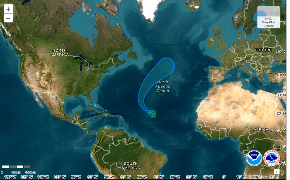
Hurricane Kirk heads towards the UK
|US NATIONAL HURRICANE CENTRE
Later in the week, the remains of Hurricane Kirk, currently whipping up winds of 125mph in the Atlantic could give the weather another rattle.
Hurricanes in their original form never reach Britain or the North Atlantic form as the tropical features quickly die over cool waters.
But their remains can hitch a ride on the jet stream, birthing a new storm or joining forces with another low in the region.
It is uncertain which form Kirk will take, although most weather-prediction models agree the UK will be affected.
McGivern said: “On Monday, Kirk moves far enough north to be picked up by the jet stream, so it stops weakening and instead it spins up in a different way and instead of deriving its fuel from warm seas it gets its fuel from upper winds that spin it and carry it to the upper Atlantic.
“Kirk is a small but very powerful system, and exactly when it enters the jet stream will have big consequences on where it ends up after that, but most likely it will come towards the UK and more or less continue the unsettled theme.”
“There are some model predictions that have that ex-hurricane heading towards the UK.
“Quite a few simulations have that ex-hurricane heading towards the UK.”
Jim Dale, US meteorologist for British Weather Services and co-author of ‘Surviving Extreme Weather’, said: “Hurricane Kirk is in the mid-Atlantic and could move into the UK in a week’s time, not as a hurricane, but a significant storm.”