


UK is currently in the grips of a cold snap with frost, wintry showers and plummeting temperatures set to affect much of the country.
Showery rain is clearing southwards from southern England and Wales today, while patchy frost is clearing elsewhere.
The Met Office forecasts sunshine and scattered showers across the UK throughout Wednesday.
Some of these showers are turning heavy and wintry, with hail and sleet expected at times.
Showery rain is clearing southwards from southern England and Wales today, while patchy frost is clearing elsewhere
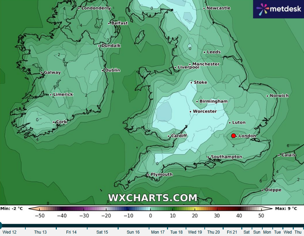
WXCHARTS
Discussing mercury's fall over the coming days, Met Office meteorologist Tom Morgan said: “Despite the temperature on the thermometer reading seven, eight or nine degrees, it is below average for this time of year. When you factor in the wind chill which will be fairly brisk on the northern and eastern coast in particular it will feel more like three to five degrees.”
He added: "Temperatures may fall as low as -4C or -5C across parts of Scotland and Northern Ireland."
Northern Ireland and western Scotland will enjoy the sunniest conditions today.
A chilly breeze is making temperatures feel particularly cold, with no immediate end in sight for the wintry conditions.
Tonight's forecast shows showers will continue to affect many eastern and some northeastern areas overnight.
These showers could turn wintry in places, adding to the challenging conditions.
MORE LIKE THIS:
- UK weather: Temperatures surge towards 20C as Britain 'hotter than Ibiza' ahead of 'Polar Vortex' warning
- UK weather: 'Icelandic ice dome' to trigger 'early spring chill' as temperatures set to plummet
- UK cold weather: 10 day freeze hits Britain as Arctic winds put nation in path of collapsing Polar Vortex
Elsewhere across the UK, it will be mostly dry with clear periods. The clear skies will allow a frost to develop in many areas.
Some icy patches are also expected to form overnight, creating potentially hazardous conditions for early morning travellers.
Temperatures will feel particularly cold, continuing the chilly theme that has dominated this week's weather pattern.
Thursday will bring another chilly day with sunshine and showers across the UK. The showers will be most widespread across central, eastern and far northern parts of the country.
Some western areas are expected to remain largely dry throughout the day.
Looking ahead to Friday, the pattern of sunshine and showers will continue. Some of these showers could be wintry, particularly on higher ground.
The weekend brings more promising conditions with fewer showers forecast. A lot of fine weather is expected on Saturday and Sunday.
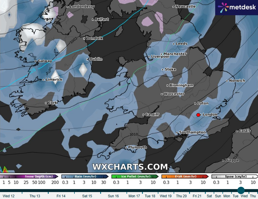
Forecasts for Wednesday, 26 March indicate snow will fall in northern Wales and Scotland
WXCHARTS
Overnight frost remains a possibility throughout the weekend despite the improving daytime conditions.
Looking ahead to late March, weather maps show another severe Arctic blast is on the way.
Forecasts for Wednesday, 26 March indicate snow will fall in northern Wales and Scotland. Northern England, particularly Cumbria, is also expected to see significant snowfall.
While southern regions may escape the snow, rain is predicted to sweep across most areas of the country.
Temperatures could feel as low as -8C around Inverness when considering the wind chill. Most parts of the UK will experience below freezing temperatures at midnight on March 26.
The cold spell is linked to a sudden stratospheric warming event affecting the polar vortex.
