


A huge storm ‘cyclone’ stretching 1,000 miles across the Arctic Ocean will hit Britain with the first snow of the season.
The UK is braced for temperatures to tumble mid-week as winter coats come out for a mini burst of 'winter’.
A deep low-pressure system spinning between Greenland and Scandinavia will put Britain in the path of a north-westerly, Arctic airflow.
Thermometers will hit freezing in northern regions while the glens and mountains get a dusting of snow.
 Britain braced for mini ‘winter’ burst as cold snap brings sub-zero chillsWX Charts
Jim Dale, meteorologist for British Weather Services and social commentator, said: “Temperatures in parts will drop low enough for an air frost, particularly in the glens and highlands of Scotland, where it is even now, slightly early in the season.
“By the middle of the week, it is going to feel colder as this chilly snap properly unfolds, and in the wind, it is going to feel cold.
“This is a bit of a winter situation, with low pressure developing over Norway and Scandinavia bringing Polar air over the UK.”
The weather will swing from wet and windy at the start of the week to cold and wintry by Wednesday, he warned.
LATEST DEVELOPMENTS: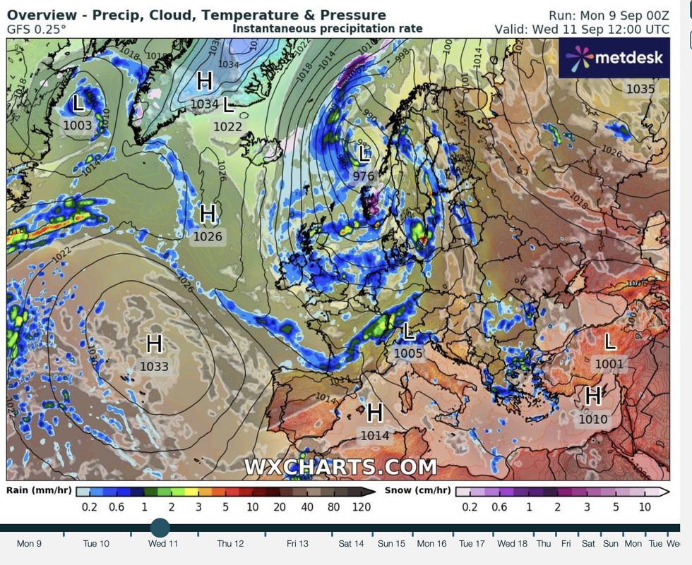
Huge low over Scandinavia to open the polar gates
WX charts
It will be cold enough even for a dusting of snow over high ground in the north, he added.
He said: “It is going to be a Jekyll and Hyde week with the wind and the rain after the weekend before turning colder towards the middle of the week.
“We are going to lurch from one air stream to another, and from T-shirts to winter coats for a time.
“There could well be a dusting of snow over high ground in Scotland and the north.”
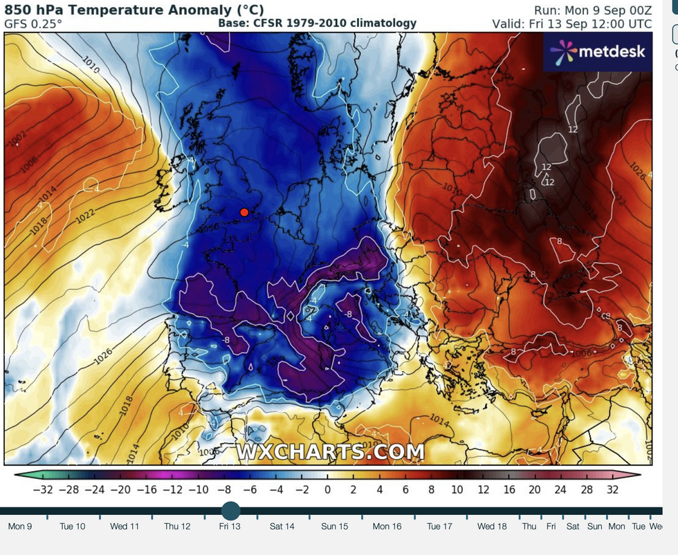
Winter’s first very early bite will be driven by a deep low-pressure – also called a cyclone–churning between Scandinavia and Greenland.
The system will over the coming days drive north-westerly winds down from the Arctic and into the UK.
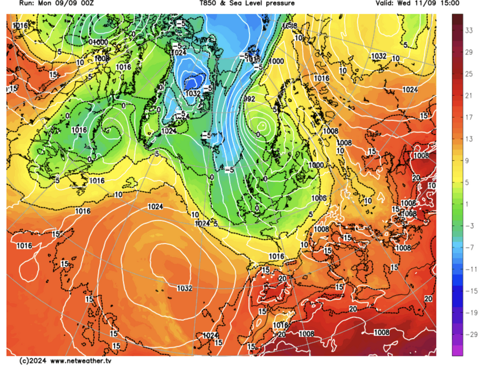
Air pressure over UK
Netweather
Temperatures in parts will dip from the slightly above-average highs seen through the start of September to below average.
It will follow another couple of wet and thundery days with parts of the country braced for more heavy downpours.
James Madden, forecaster for Exacta Weather, said: “The unsettled and thundery weather has kicked in a bit earlier than expected, but it will be midweek that things turn really grim with a significant drop in temperatures.
“It may even at times between Tuesday and Thursday turn cool enough for some non-significant wintry weather across the highest ground, but this is most likely around Thursday.”
Scotland and northern England could feel the first bite of the cold as soon as Tuesday, according to the Met Office.
Met Office meteorologist Greg Dewhurst said: “Temperatures are generally holding up under the cloud and rain on Tuesday, but generally starting to turn colder across northern Scotland and the northerly air starts to filter southwards.
“A cold front sinks southwards bringing cloud and rain, behind it, it is turning brighter but the winds staying strong particularly across northern Scotland with some heavy rain across Orkney and Shetland combined with some strong winds could lead to some disruption.
“Wednesday is quite a cold day for everyone, with perhaps a frost first thing across the far north of Scotland.”
