


Britain’s winter woes are about to thaw amid hints of the arrival of a ‘Bermuda’ weather feature more typical of a summer heatwave.
Ice and Arctic gloom will give way this week to glimmers of sunshine and temperatures in the mid-teens.
The first flavours of spring will break through as the Azores High – a high-pressure system near Portugal – stretches towards Britain.
Also known as the ‘Bermuda High’, it usually heralds the start of summer warmth, blue skies and sunshine.
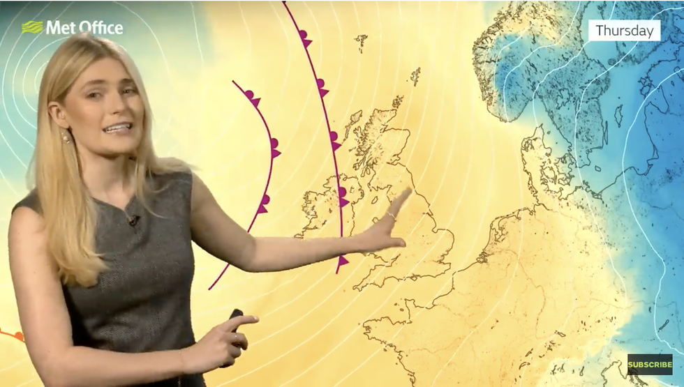
Met Office’s Kathryn Chalk describes milder weather incoming
Met Office
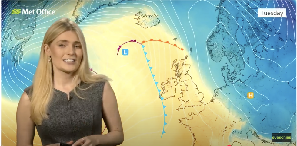
Met Office’s Kathryn Chalk describes milder weather incoming
Met Office
But Atlantic low-pressure spells a slow and unsettled run-up to the sunshine, with the full force of the Azores High for now just out of reach.
Met Office meteorologist Kathryn Chalk said: “There are signs of change to come as we reach mid-week with milder conditions on the way.
“We are still in this battleground with high pressure to the east and a deep area of low pressure out towards the west.
“But as we go through the week, we will start to draw up much milder air, especially on Wednesday and more so into Thursday moving up from the Atlantic, so temperatures will be rising but there will be some windy conditions as well and we will still have some fronts moving through to bring some spells of rain.
“But otherwise, temperatures will be climbing.”
LATEST DEVELOPMENTS: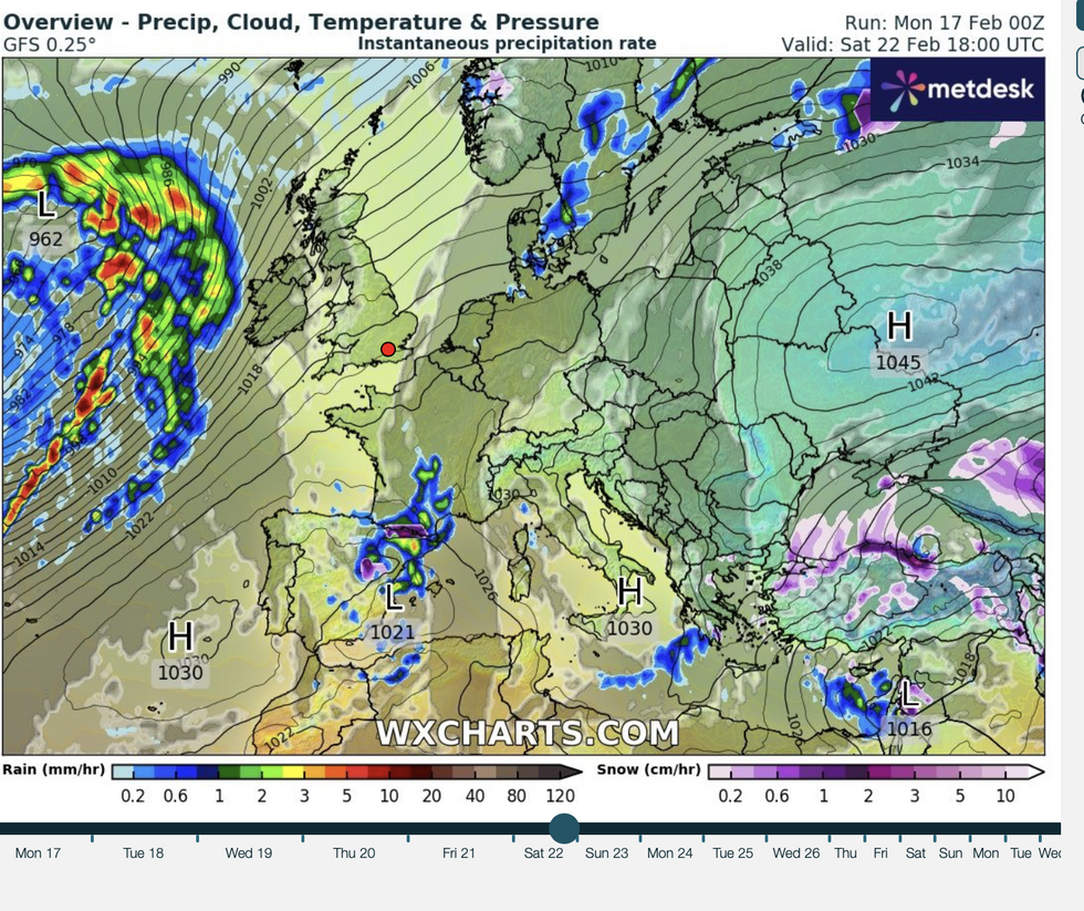
Azores high nudges in from the west
WX charts
Britain’s weather through the past fortnight has been dominated by high pressure to the east, driving cold north-easterly winds.
Previously, low pressure to the west hauled into the UK on a powerful jet stream drove a stormy mid-winter.
The jet is still wedged over the UK, meaning more wet and windy weather is likely through the next week.
However, the closer-creeping Azores High could spell the end to the freezing rain and storms.
Jim Dale, meteorologist for British Weather Services and social commentator, said: “Mild air is going to start coming in from the west and the southwest and by the end of the week we are going to see temperatures in the mid-teens.
“We are between systems, so the milder conditions will start to come in from the west and the southwest.
“However, with that milder weather at times will be frontal systems, and this means there will be the risk of some rain and at the start of the week, the risk of snow over the higher ground of Scotland.”
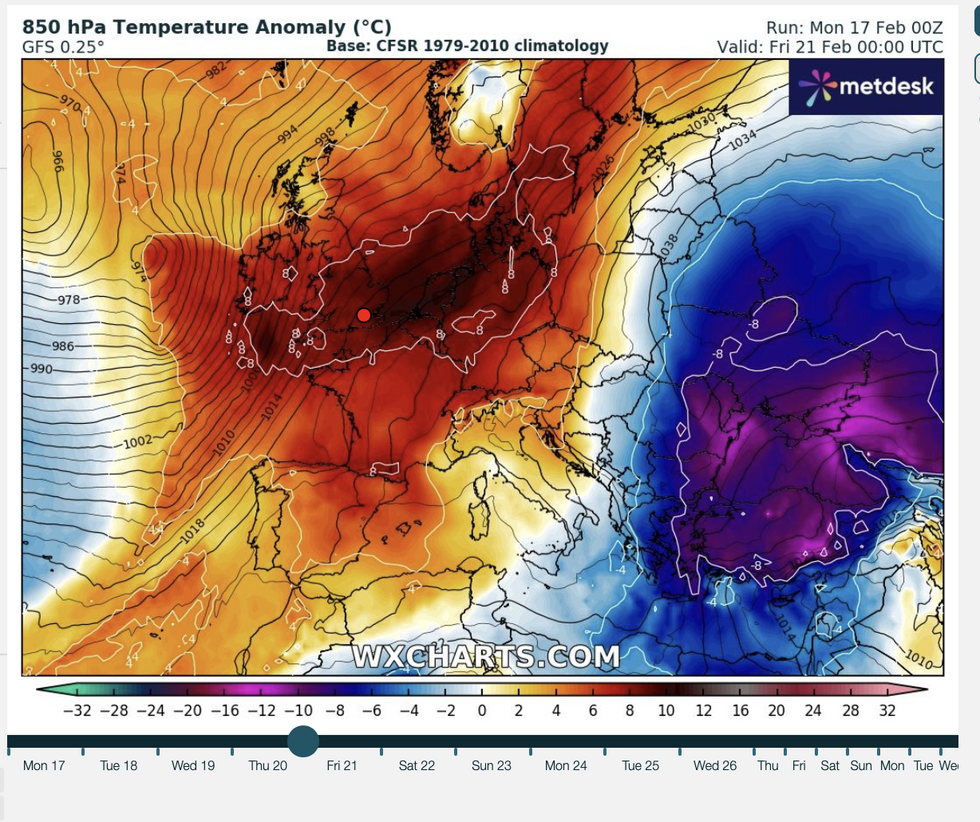
Temperatures to feel unseasonably warm
WX Charts
While the Azores High shows signs of reaching north-eastwards towards Britain, its true magic does not usually emerge until later in the year.
It was behind the 40.3C record-breaking heatwave of 2022 and frequently dominates weather charts during hot weather in June, July and August.
Currently, a battle between easterly high pressure which has brought the recent cold, and a giant low to the west will be dominant in driving mild temperatures.
And with the Atlantic still in charge of the weather, wind and rain will remain prominent.
Met Office deputy chief meteorologist, Tony Wisson, said: “Milder but unsettled conditions are moving in from the Atlantic later this week.
“As the week goes on, we’re set to experience wetter conditions with showers and bands of rain moving in from the Atlantic.
“There will be brighter and sunnier spells in between bands of rain. With temperatures possibly as high as 16°C on Thursday and Friday, it will feel much more spring-like than of late.”
