


Britain will see temperatures plunge next week as a snap spell of freezing weather from the nordic region makes its way south.
The cold weather will see temperatures drop some meteorologists warning that temperatures will struggle to get above 2C for most of the country.
And the sudden freezing conditions will see a chance of heavy snowfall for parts of the country in the middle of the week.
Speaking to GB News, weather journalist Nathan Rao said: "Hold onto your hat because we are going to get snow and we are probably going to get a lot of it.
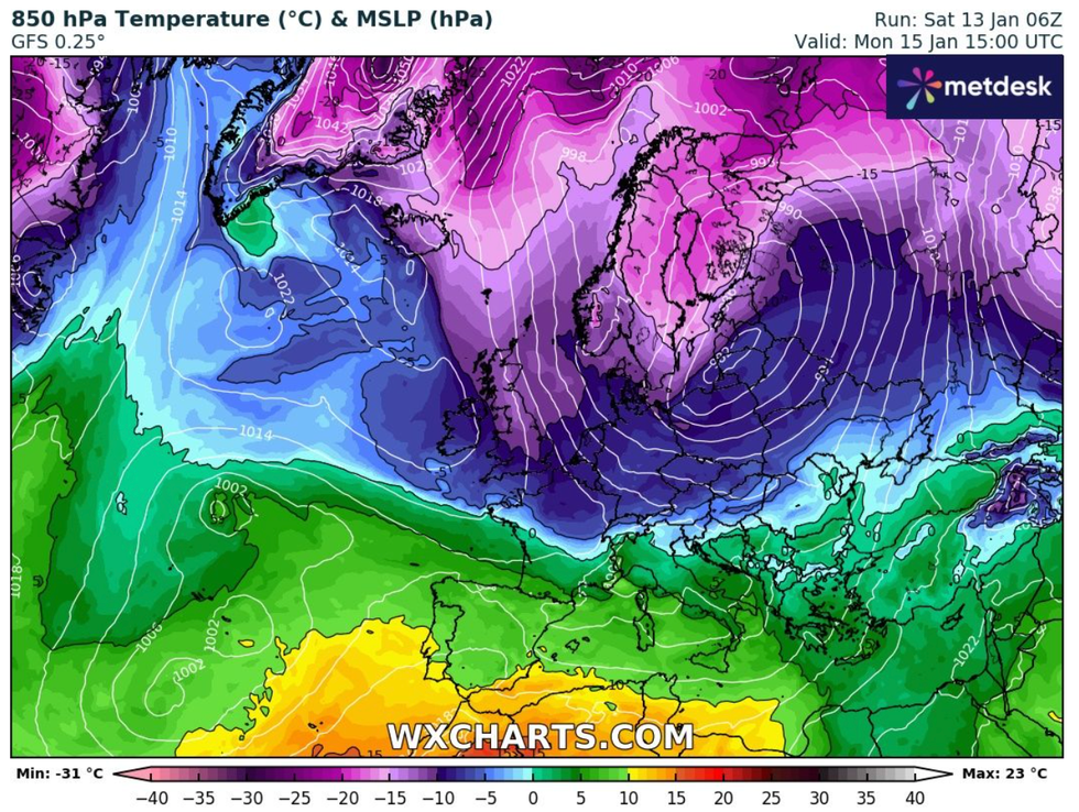
The cold blast will descend from the Arctic
WX CHARTS
"The jaws of the Arctic have opened and we are right in the firing line of an Arctic blast.
"Today and tomorrow I think people across the entire country are going to start noticing the chill, because that is when that cold, northerly blast is going to come right down through Scotland and over the whole country."
The Met Office is forecasting "overnight frosts and ice" from Monday with "more significant snow possible for northern areas on Tuesday".
It added that there was also a chance of snow in the south on Wednesday but that there was presently "lower confidence" around what would happen.
"There are two things happening. On Tuesday there is a low coming in from the West which will bring some snow around northern, central England. We don't know where yet - they never do - it's hard to pinpoint exactly where," Rao added as he outlined the latest Met Office forecasts.
"Then going further into the week on Wednesday there is another low that is going to come in from the south and that could bring snow and rain into the south."
Weather maps from WX Charts suggest Scotland and anywhere north of Manchester in England will bear the brunt of the winter conditions.
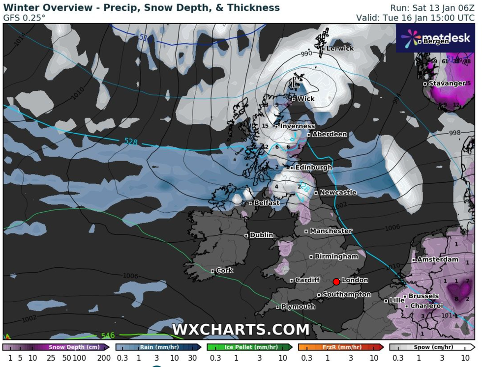
Snow will hit Scotland and northern of England on Tuesday
WX CHARTS
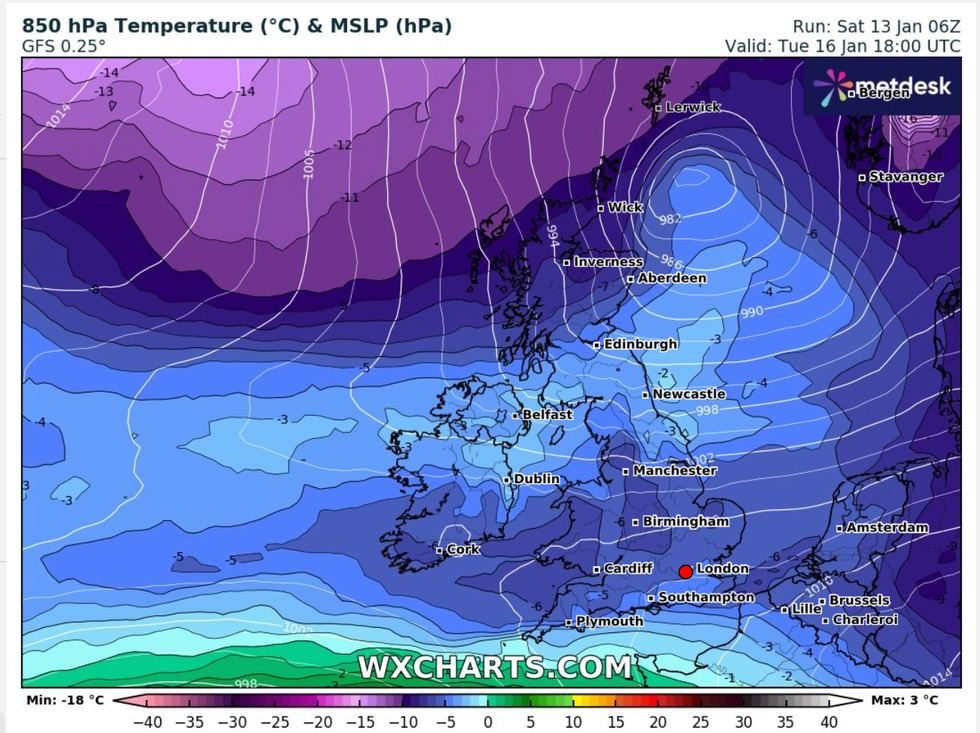
Temperatures will remain close to freezing through the week
WX CHARTS
Earlier forecasts had suggested that there would be widespread snow across the whole UK next week, but NetWeather's Ian Simpson said that weather models had suggested that "the potential for widespread snow has receded recently".
"We are about to head into a spell of cold northerly and north-westerly winds, associated with a blocking high over Greenland," he said.
"The cold spell will not be especially prolonged, and there is very strong agreement among the medium-range forecast models that mild and moist south-westerlies will push in by next weekend."
Simpson added: "The cold air will be firmly established in all parts on Monday. South-west England and south Wales will see top temperatures of around 5C, but elsewhere they will generally be no higher than 2 or 3C.
"It will be a dry sunny day for most, with snow showers mainly restricted to north-facing coasts, with a few brushing against western and eastern coastal fringes.
"Northern Scotland, Northern Ireland and the east of Norfolk will probably see the most showers, with a widespread snow cover in northern Scotland.
"On Tuesday and Wednesday there is now just a low chance of a frontal system pushing into the south of Britain, and with a pool of less cold air moving in from the west at the same time, if the system does push into the far south there is a fair chance of precipitation mostly being rain at low levels.
"However, this less cold air will be associated with a frontal system which will bring snow on its northern flank for Northern Ireland, northern England and the Midlands, with snow generally to low levels in northern England and on higher ground elsewhere, perhaps with snow penetrating to low levels in the Midlands for a time as the system clears away south-eastwards.
"Snow showers will continue in northern Scotland, which will remain in a cold north to north-westerly regime.
"Snow showers may develop more widely in western Britain on Thursday as the wind will change to a north-westerly direction, but it looks set to turn mild and wet through Friday and Saturday."
