


Summer will once again arrive and vanish in a flash with a mini ‘heatwave’ to erupt in thunder, plunging Britain back into the doldrums.
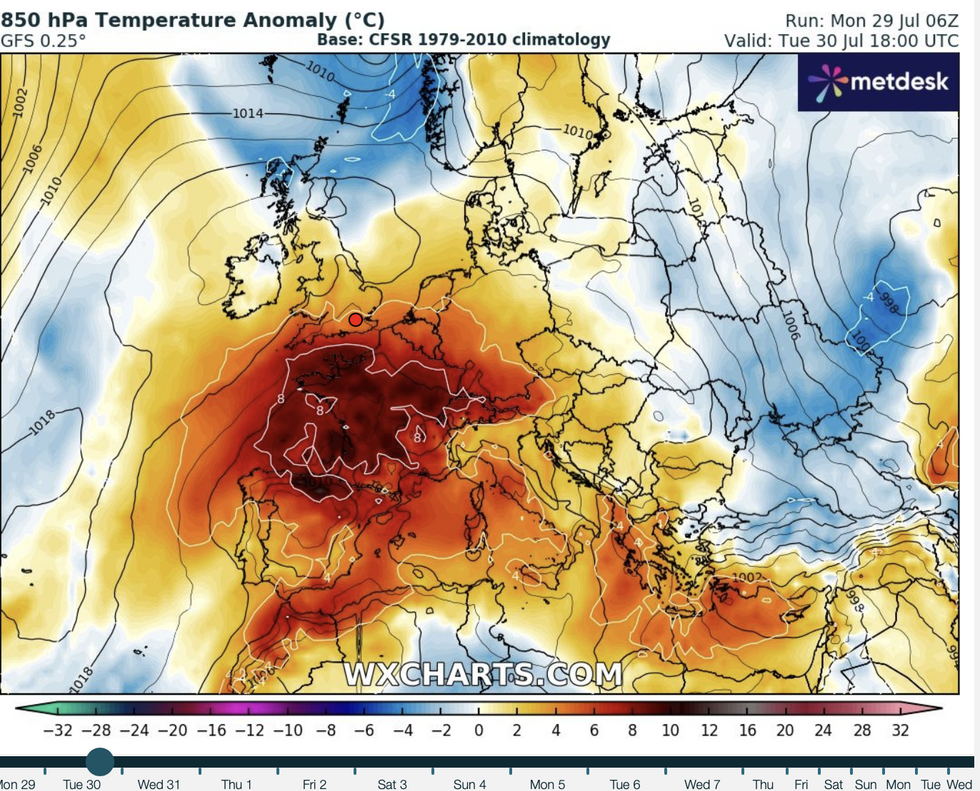
Sun-seekers will be flocking to catch the rays through the start of the week as thermometers rocket into the low-30Cs.
But just as barbecues begin to warm, the sun will do yet another runner opening the gates to torrential rain.
The heavens will open on Thursday in an explosion of thunderstorms before a weekend cooldown.
 UK hot weather: Britain to roast in 30C mini-heatwave before thunderstorms send temperatures plummeting WX charts
Met Office deputy chief meteorologist David Oliver said: “On Thursday, there is a signal for some potentially very heavy thunderstorms.
“The heaviest showers could result in 20mm to 30mm of rain within an hour, with daily totals possibly reaching as high as 90mm if multiple showers impact the same location.
“Lightning and hail present additional hazards, with disruption likely for some.”
Britons are urged to make the most of the imminent fine weather with the next 48 hours promising the hottest day of the year so far.
London and the southeast will see the highest temperatures where the low-30Cs are possible, experts say.
LATEST DEVELOPMENTS: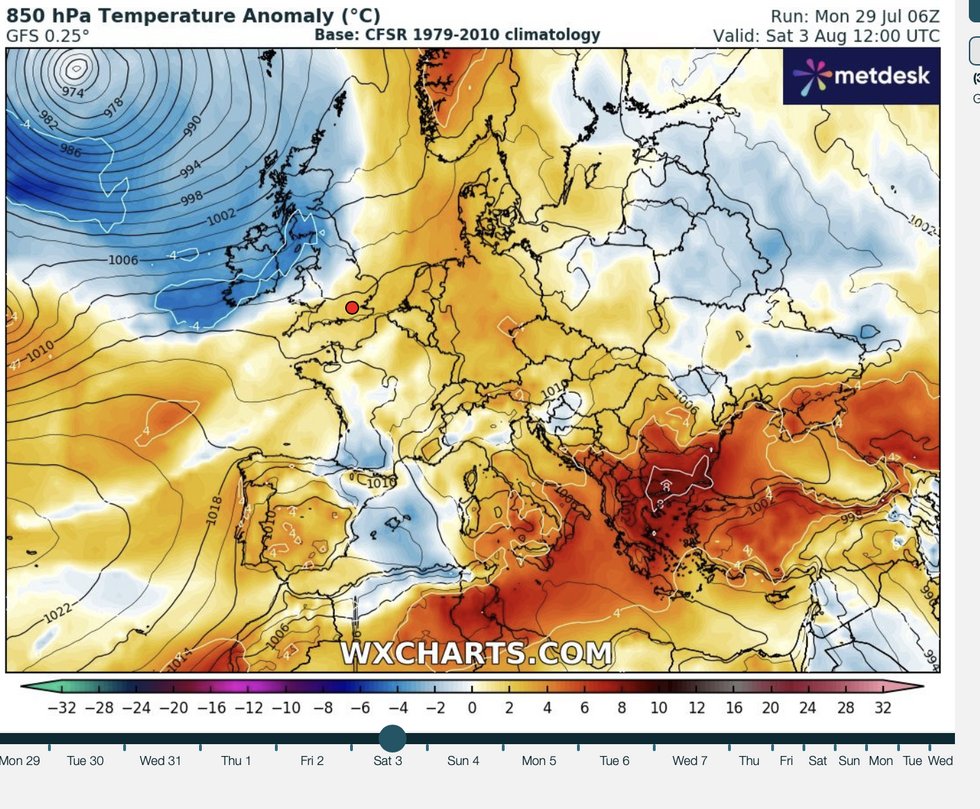
Britain to cool down as low pressure system approaches
WX charts
Elsewhere will enjoy a flush of warmth as a tropical plume sweeps in from the Continent.
Exacta Weather forecaster James Madden said: “Heat will start to build and push temperatures into the 30Cs through the start of the week to around Wednesday.
“This is likely to be a three to four-day period of warm weather with the highest temperatures across southern Britain.
“However, further north and even into Scotland, high pressure will rise and push temperatures into the mid-to low-20Cs or higher.”
The UK will officially enter heatwave territory, with warnings in force to take extra care through the coming days.
To qualify as a heatwave, the period must see temperatures above threshold levels for three days – 28C in the south and slightly lower further north.
A yellow ‘heat health alert’ has been issued by the UK Health Security Agency until Friday.
The warnings cover the whole of southern Britain with northern regions under a less serious green alert.
Heat Health alerts released by the UK Met Office warn of ‘Significant impacts across the health and social care sector due to the high temperatures’.
Met Office chief meteorologist Frank Saunders said: “Much of the UK is entering a warm or even hot interlude of weather, with some places in England and Wales likely to meet heatwave criteria in the coming days.
“Temperatures are likely to peak at around 32C in southeast England on Tuesday and Wednesday, with much of the UK experiencing dry, fine and warm conditions in the first half of the week.”
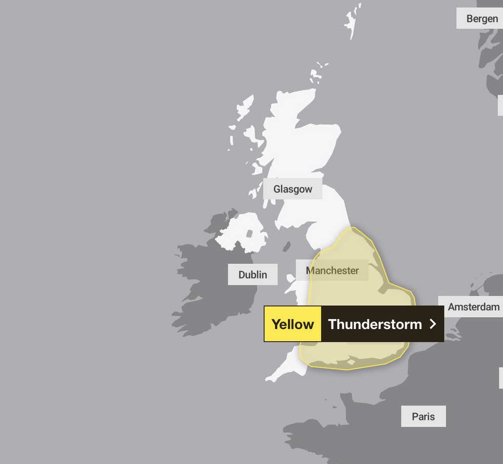
Met Office thunderstorm warning in force
Met Office
The next threat lurks in the form of thunderstorms, with heat and humidity forecast to go bang on Thursday.
The Met Office has issued a yellow severe weather alert for storms across much of the south.
Jim Dale, meteorologist for British Weather Services and co-author of ‘Surviving Extreme Weather’, said: “There will be a few sporadic outbreaks on Wednesday, with Thursday to bring a more pronounced breakdown of the heat.
“Through the start of the week, temperatures will rise, and we could see Tuesday as the hottest day of the year so far.
“This will be in London and the southeast of the country, as a plume of warm air comes in from Spain.”
Northern regions will cool down by the weekend with southern Britain to hang on to warmer weather, experts say.
