UK hot weather: Britain set for mini-heatwave with TWO weeks of dry sunshine
PA/WX Charts
According to Netweather, max ‘feel like’ temperatures could reach 25C
Don't Miss
Most Read
Trending on GB News
Britain is set to bask in mini-heatwave complete with glorious heat and sunshine for two weeks as an area of high pressure could send temperatures surging into the low 20s.
Rain-soaked Britons will be excited to learn that the cold, wet conditions experienced last month will soon be comfortably in the rear-view mirror.
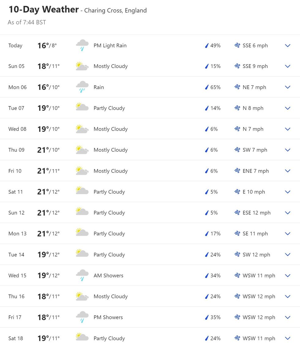
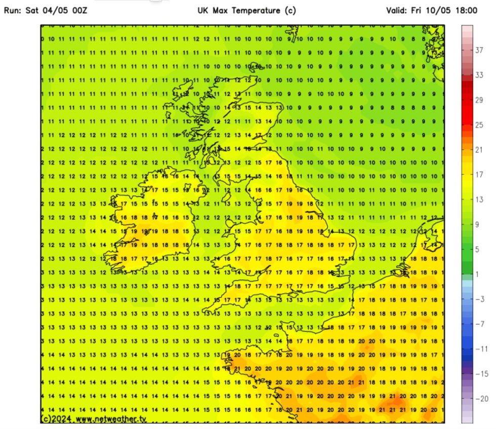
Weather maps and 10-day weather forecasts predict temperatures in the UK could reach 21C in places.
However, if conditions are right, more localised ‘feel like’ temperatures could reach as high as 25C by Friday, Netweather has said.

The Weather Channel predicts temperatures will remain in the high teens until mid-May
The Weather Channel
According to the Met Office long-range forecast for May 8 to 17, there is a “strong signal for a continued build of high pressure across the UK by the middle of next week.
“This will bring more in the way of dry and fine weather for most areas, although there is still a chance of some showers in places at first, and a risk also of some more persistent rain rounding the high into north-western parts of the country.
“The high is likely to maintain influence into the weekend before starting to weaken the following week.
“So a continuation of fine conditions next weekend seems likely, before a return of less settled conditions by the end of the period. Temperatures are expected to be slightly above normal for early May.”
LATEST DEVELOPMENTS:
Despite maps showing temperatures at 19C, 'feel like' temperatures on Friday could reach 25C
Netweather
Echoing the Met Offier, Netweather’s long-range forecast suggests that although drier spells are likely, there is the potential for low pressure to bring downpours.
It reads: “Blocking high pressure could be present at times to the northeast or close to the north, bringing the potential for drier weather, but may be far enough away to allow low pressure to control UK weather at times too, bringing a mix of drier spells and more unsettled periods.
“Overall, it’s looking like a warmer-than-average month, with the flow more likely from the east, south or southwest. Potential for one or two very warm spells, but risk of thundery weather, particularly later in the month.
“Rainfall likely to be around average overall, but perhaps quite wet in the west, drier in the east. The start of the month most likely to be drier than later in month.”
However, in its outlook for next week, the forecaster suggests that high pressure will bring “warm, dry and predominantly sunny weather, especially in the south of Britain”.
“Towards midweek, we can expect the high pressure to establish over much of the country, maintaining predominantly dry and sunny weather for a large majority of the country.”
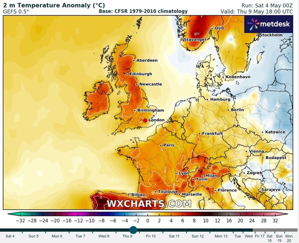
It adds that average temperatures are forecast to be around 2C above the 1991-2020 long-term average and that “sunshine is forecast to be above average for most parts of the UK”.

Temperatures are likely to be above average
WX Charts
Taking to Twitter, forecaster Paul Blight, suggested an Iberian heat dome could be the answer to the UK’s heatwave mystery.
He wrote on Friday: “Models are suggesting yet another 500mb/850mb Heat Dome will develop over the Canary Islands, NW Africa & eventually possibly Iberia over the coming 10 days.
“Since last summer I have now lost count of the number of these heat domes that have developed replacing the normally reliable NE Trade winds which bring relatively temperate heat to the Canaries & the coasts of Morocco.
“These heat domes are also fuelling the unusually warm Tropical Atlantic & now yet another one could develop in the next 10 days or so.”


