


Hurricane Beryl will crash into a blazing heat dome smothering America, spawning a ‘swarm’ of frenzied tornadoes.
After blitzing the Caribbean and Mexican Yucatan Peninsula last week, the former category-5 hurricane weakened to a tropical storm.
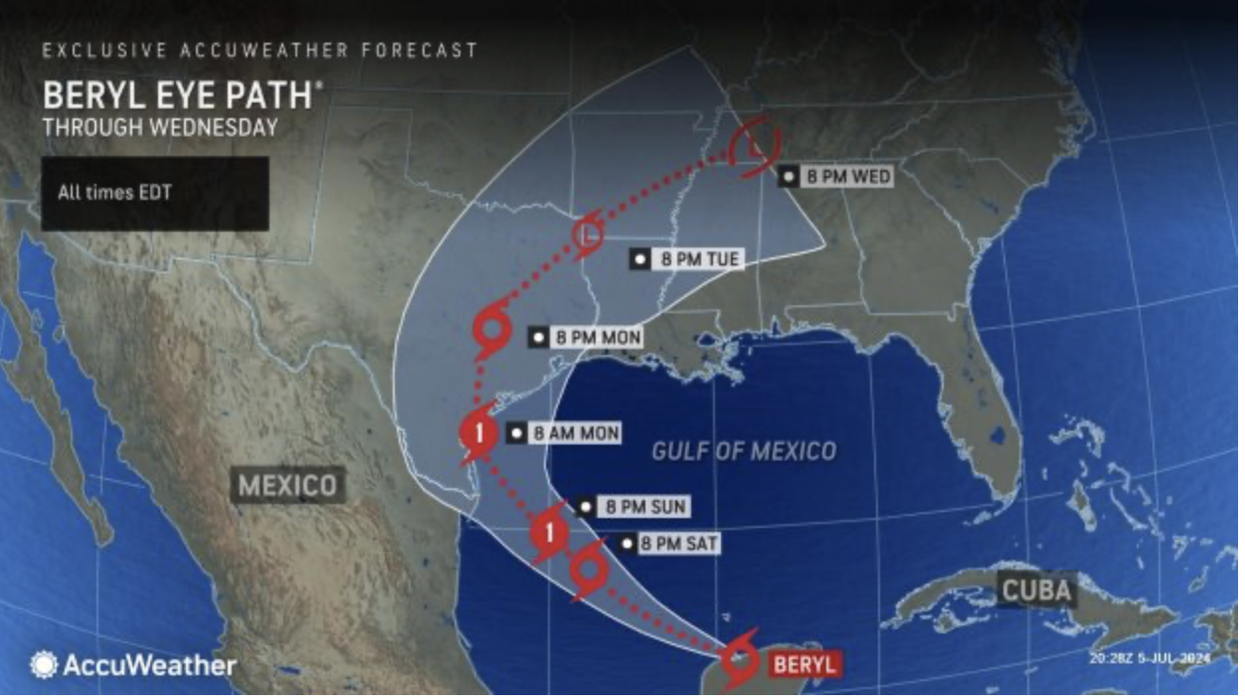
But it has restrengthened overnight into a category-1 hurricane and is hurtling towards the southern Texas coastline.
Energy from the monster storm will plough through eastern states unleashing torrential downpours, thunder and tornadoes.
AccuWeather meteorologist Jon Porter said: “Tornadoes and waterspouts are possible in Texas this week as Beryl moves inland.
“Some tropical systems bring a swarm of tornadoes upon making landfall, while others bring very few tornadoes.
 Hurricane Beryl will crash into a blazing heat dome smothering America | ACCUWEATHER
“If dry air can spiral into the storm's circulation as it moves onshore, the risk of severe thunderstorms and tornadoes may increase, particularly over the storm's eastern and north-eastern sections.”
Raging heat across swaths of the US since the start of summer will push temperatures again this week into the 110Fs.
A high-pressure ‘heat dome’, the driver for the heatwave, will wedge over western states battering Beryl eastwards.
While she will die quickly after hitting land, her remnants are forecast to get swept into weather systems across the states.
Jim Dale, US weather correspondent and meteorologist for British Weather Services, said: “Beryl is going to meet this massive dome of heat over America, and this will bring thunderstorms and heavy rain to the south of the country.
“Through the week, the remnants of the hurricane will move around this dome to the northeast of the country where it will trigger further outbreaks of severe weather.
“There will also be a risk of tornados, some of which could be damaging, as the remains of the hurricane move through the country.”
Southern states were last night on alert for Beryl to drag in a massive ‘sea swell’ and storm surge.
National authorities warned people to take extra care in coastal regions with 10ft waves possible.
The storm will be guided by a dip in the jet stream, pulling it north-north-westwards, and causing it to stall over land.
AccuWeather chief on-air meteorologist Bernie Rayno said: “As Beryl approaches the Texas coast, a dip in the jet stream will act like a magnet and pull the storm more to the north and northwest.
“We’re expecting Beryl to make landfall near Corpus Christi as a Category-1 hurricane and slow down as it approaches the Texas coast, and that could cause some big flooding problems.”
Porter added: “If that rain comes too fast and too furious, significant and life-threatening flooding can occur. We’ve seen it before with hurricanes in Texas.”
The US National Weather Service (NOAA) warned Texas to brace for tropical-storm-force winds.
A spokesman said: “Beryl, which is currently a Tropical Storm, is forecast to strengthen to a Hurricane before making landfall early Monday morning.
“Tropical Storm force winds could develop as early as this evening for the upper Texas coast.
“Heavy rainfall, severe thunderstorms, as well as strong rip currents and coastal inundation from storm surge are the most likely impacts from Beryl.”