Nasa spots 'city under the ice' nuclear base in Greenland
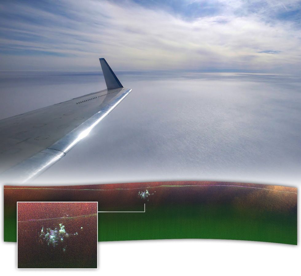
The latest mapping has revealed the base's original layout, showing parallel structures that correspond with the historic tunnel network
Don't Miss
Most Read
Trending on GB News
Nasa scientists have uncovered a hidden Cold War-era military base beneath Greenland's ice sheet using advanced radar imaging technology.
The remarkable discovery was made during an April 2024 flyover, when researchers aboard Nasa's Gulfstream III jet captured unprecedented views of the buried installation.
"We were looking for the bed of the ice and out pops Camp Century. We didn't know what it was at first," said Alex Gardner from Nasa's Jet Propulsion Laboratory (JPL).
The radar imaging revealed detailed structures of what was once known as Camp Century, now completely buried beneath layers of snow and ice.
Using Nasa's sophisticated UAVSAR instrument mounted to the aircraft's belly, scientists were able to produce detailed maps that showed the abandoned base's layout in remarkable clarity.
Camp Century was originally constructed in 1959, built by creating an intricate network of tunnels beneath the surface layer of Greenland's ice sheet.

Nasa has published new images of the 'city under the ice'
NASA
The military installation remained operational for less than a decade, before being abandoned in 1967.
In the decades since its abandonment, continuous snow and ice accumulation has buried the facility's structures deep beneath the surface.
Scientists now estimate the base lies at least 30 metres (100ft) below the ice sheet.
The latest mapping has revealed the base's original layout, showing parallel structures that correspond with the historic tunnel network.
Researchers are particularly interested in tracking the site's depth, as it could help determine when melting ice might expose the camp and any remaining biological, chemical, and radioactive waste buried within.
The new UAVSAR technology marks a significant advancement over previous survey methods used in Greenland.
Earlier airborne surveys only produced two-dimensional profiles of the ice sheet, whilst the new instrument offers far more detailed mapping capabilities.
"In the new data, individual structures in the secret city are visible in a way that they've never been seen before," said Nasa scientist Chad Greene.
The advanced radar imaging has been cross-referenced with conventional radar data to verify Camp Century's depth measurements.
"Our goal was to calibrate, validate, and understand the capabilities and limitations of UAVSAR for mapping the ice sheet's internal layers and the ice-bed interface," Dr Greene explained.
The breakthrough demonstrates UAVSAR's potential for creating highly detailed subsurface maps of ice-covered regions.
The discovery has significant implications beyond mapping abandoned military installations.
Scientists believe this technology could revolutionise how we measure ice sheet thickness in similar environments, particularly in Antarctica.
This capability is crucial for understanding how climate change affects polar regions.
"Without detailed knowledge of ice thickness, it is impossible to know how the ice sheets will respond to rapidly warming oceans and atmosphere, greatly limiting our ability to project rates of sea level rise," Dr Greene emphasised.
The successful test survey has opened new possibilities for future research.
Scientists are optimistic that these results will pave the way for the next generation of aerial mapping in Greenland, Antarctica, and beyond.
The technology's ability to provide detailed subsurface mapping could prove invaluable in predicting and understanding global sea level changes.


