'More disruption!' Storm Herminia is on the way to 'roll and rattle' the UK in the wake of destructive Eowyn

Nathan Rao predicts more 'spicy' storms to come after storm Eowyn batters UK
|GB News

The caution comes as Britain and Ireland continue to reel from Storm Eowyn
Don't Miss
Most Read
Latest
Weather analyst Nathan Rao has warned that Storm Herminia is set to bring more disruptive weather to the UK this weekend, following in the wake of the destructive Storm Eowyn.
The caution comes as Britain and Ireland continue to reel from Storm Eowyn, which brought winds of up to 114mph.
The Met Office has issued several warnings as Storm Herminia approaches, with alerts spanning Sunday through Tuesday.
A yellow warning for wind will be in force from 8am to 3pm on Sunday across parts of the North West and South West of England, Wales, and south-west Scotland.

Nathan Rao said another storm is on the way
|GB News
Speaking to GB News, Rao said: "Storm Eowyn was a particularly bad storm, as you mentioned. 114 mph. Now, that's up there with some of the worst storms that we've had, the great storm of 1987. Some of us will remember that was gusts of 134 mph.
"But when you start getting gusts of 100 mph or more, which this storm delivered, we're really up there with some very destructive, damaging winds. Those are going to continue into the early hours this morning.
LATEST WEATHER DEVELOPMENTS
"The amber warning for wind from the Met Office in northwest Scotland is in place until about 6pm, so that should be expiring soon.
"But it has been a windy day with a lot of cleanup and a lot of destruction as the winds continue to batter the northwest of the country and Storm Eowyn moves off to the northeast.
"It will become calmer. It's going to get colder along the west coast, as Storm Eowyn's tail end drags in some colder air, and then there is going to be some more disruptive weather as we go through the weekend with another storm.
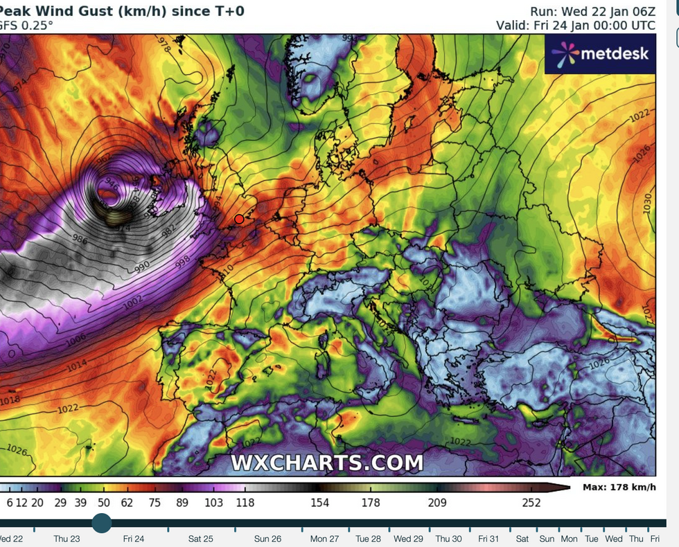
"Storm Herminia is on the way. This is going to be less destructive than Storm Eowyn, and it's going to sit off the west coast of England, but some more disruptive wet and windy weather all the way through this weekend."
 Storm Eowyn rolls in | WX charts
He explained: "They keep rolling and rattling in. So this isn't going to be the last storm that we see for the next few weeks, months. I would anticipate and I would expect that some of them could be just as spicy."
Wind gusts of 50 to 60mph are expected widely, with potential for 70mph gusts around exposed coasts and hills.
The Lancashire and Merseyside coast will be affected, though Greater Manchester is expected to escape the worst of the winds.
Disruption continues across the UK as recovery work takes place in the aftermath of Storm Eowyn.
Met Office meteorologist Aidan McGivern said: “There will be more blustery weather throughout Sunday into Monday and potentially beyond that as the weather stays very unsettled.
“If we skip forward to Tuesday, we can see that a low is still sitting to the west and northwest of the UK, and this is the most likely weather pattern for Tuesday as it is looking very unsettled.
“It is likely to stay unsettled throughout next week.”


