


The US hurricane season is about to explode amid warnings the sixth tropical storm of the year – Francine – is on the way.
Meteorologists have urged Americans during the next month to brace for an ‘uptick in tropical threats’.
September traditionally brings a storm peak, but unusually high ocean temperatures and atmospheric volatility could deliver a supercharged season.
Late summer delivered a taste of the might of the Atlantic, most notably in the past weeks with Beryl, Debby and Ernesto.
Possible path of Francine
|The Weather Channel
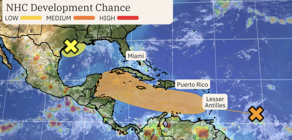
The US National Hurricane Centre is keeping a close eye on a flurry of ‘tropical disturbances’ brewing off the US coast.
Weather Channel meteorologist Caitlin Kaiser said: “This ‘Potential Francine’ is developing in an area that's very common for activity this time of year.
“September is hurricane season's busiest month in the Atlantic, so we anticipate enhanced tropical development in the coming weeks.
“The National Hurricane Centre (NHC) is tracking two areas of possible development in the Atlantic Basin, one of which could form into a tropical depression or storm as it heads toward the Caribbean, and another system bubbling near the Gulf Coast.”
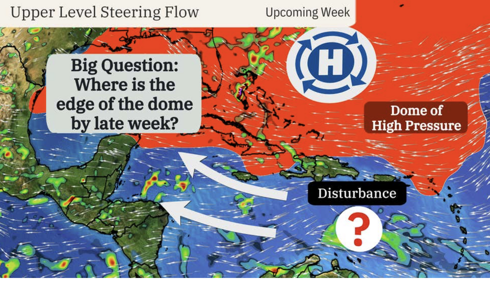
A dome of high pressure –the Bermuda High– near America will steer any tropical storm along the south coast and westward towards southern states.
It would then move northwards, depending on the position of high pressure, possibly impacting the Great Lakes and northeast.
LATEST DEVELOPMENTS:
National Hurricane Centre hurricane development
|The Weather Channel
Ms Kaiser said: “The system will be steered westward by high pressure to its north, reaching the Lesser Antilles by Monday or Tuesday.
“The strength of the Bermuda High and resulting upper-level pattern will help determine where exactly this system tracks.
“It's too early to know what, if any, threat this system might pose to the continental United States, but multiple models suggest that development is more likely as we near the peak of hurricane season.”
The US has been hit by several tropical storms with the season kicking off with Alberto in June, before later in the summer Beryl, Debby and Ernesto packed a bigger punch.
A lull in storm activity in August was driven by a cloud of Saharan dust which swept over the Atlantic keeping a lid on hurricane development.
Potential tropical storm development
|AccuWeather
The sand-cloud has vanished, and above-average ocean temperatures combined with a swing from El Nino to a La Nina cooling of the east Pacific, the next few weeks could be particularly spicy.
AccuWeather meteorologist Jon Porter said: “Despite the recent lull in the tropics, our meteorologists are urging people to prepare for an uptick in tropical threats in the month of September and beyond.
“While a total of 20-23 named storms is most likely, we cannot rule out 24 or 25 storms due to factors including reduced wind shear as the season progresses, very warm water, an intensifying La Niña through and the forecast of less dry, dusty air present in the atmosphere over the tropical Atlantic Ocean.”
Jim Dale, US meteorologist with British Weather Services and co-author of ‘Surviving Extreme Weather’, said: “There is the potential for Francine at the end of the week, so this is something that will need to be watched.
“It would largely affect the southern coast of the US, before potentially moving northwards steered by high pressure towards the Great Lakes and the surrounding regions.”