US weather: Millions of Americans face 'life-threatening floods' as 'bomb cyclone' storm rides 2,000-mile 'atmospheric river'

The assault will be driven by a rapidly strengthening ‘explosive cyclogenesis’ storm
Don't Miss
Most Read
A ‘bomb cyclone’ storm riding a 2,000-mile ‘atmospheric river’ threatens millions of Americans with power outages, toppling trees and ‘life-threatening floods’.
Torrents of rain will drench swaths of the US as an ‘unusually potent’ weather system smashes in from the Caribbean.
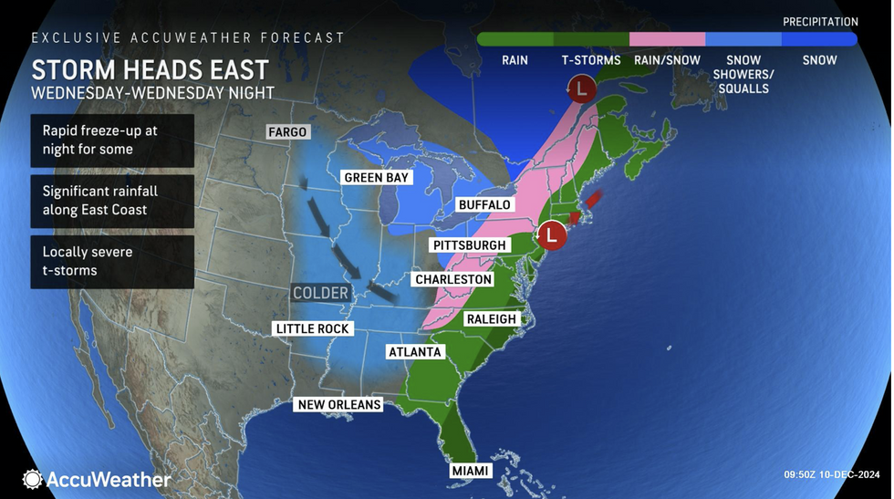
The assault will be driven by a rapidly strengthening ‘explosive cyclogenesis’ storm – also called a weather bomb or bomb cyclone – and a stream of moisture from the tropics.
So-called atmospheric rivers are more usual along western coasts facing the Pacific, though the east is now in the firing line.

The storm will potentially move east
|AccuWeather
AccuWeather chief meteorologist Jon Porter said: “Atmospheric rivers, swift-flowing currents of moist air, are known for their ability to produce heavy rain across the West Coast, often resulting in significant flooding.
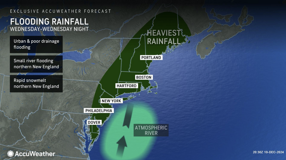
“They can also occur along the East Coast of the United States, and this atmospheric river will be unusually potent and moisture-loaded, delivering tropical moisture into the intensifying storm from the Caribbean Sea, some 2,000 miles away.
“The result will be heavy rain and the risk of significant flooding, especially near streams and creeks. Some roadways may be closed by flooding.”
New England and the northeast will see the heaviest rain fall on melting snow to bring the risk of ‘life-threatening’ floods, he warned.
Up to four inches of rain could fall widely with a foot forecast in the direct path of the storm which will whip up 70mph winds.
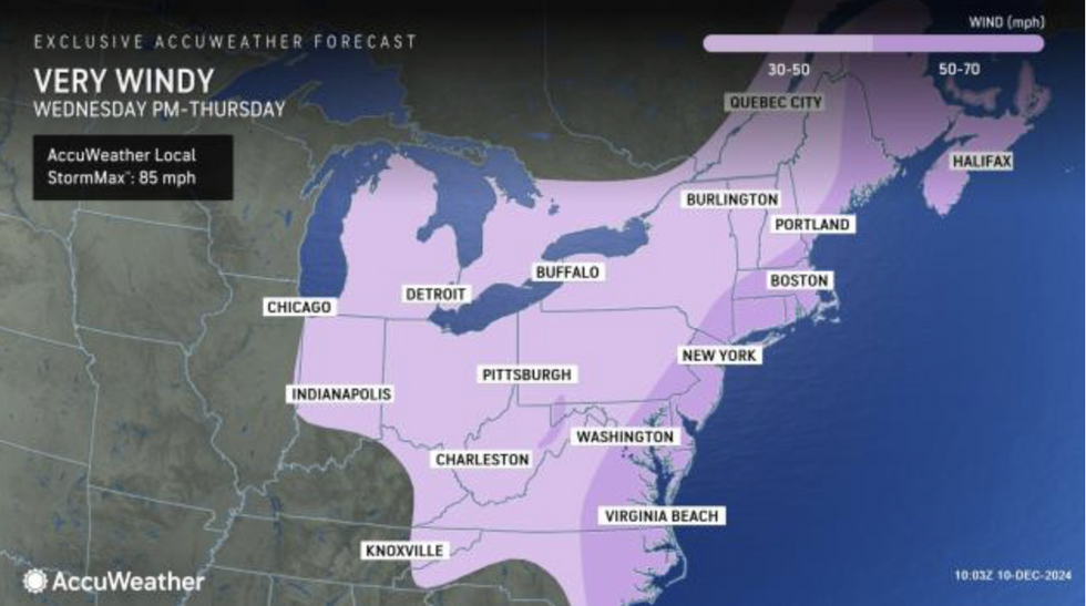
Porter said: “Wind gusts of 50-70 mph could bring down trees and utility lines, leading to widespread power outages.
LATEST DEVELOPMENTS:

There are going to be max speeds of 85mph
|AccuWeather
“The risk for significant flooding will be amplified across the higher elevations of Vermont, New Hampshire and Maine where there is a considerable snowpack of several inches on the ground.
“Rapidly melting snow can add another 1 to 2 inches of liquid water to the runoff. Rapidly rising water can lead to life-threatening flooding, especially in areas of steep terrain.”
The storm will hit mid-week making before ploughing east into the west Atlantic ahead of the weekend.
It will clash into Arctic air left from the cold snap driving heavy snowfall across the hills and mountains.
The storm, driven by a rapid drop of pressure called ‘explosive cyclogenesis’ threatens thunderstorms and the risk of tornadoes.
AccuWeather meteorologist Bernie Rayno said: “Locally severe thunderstorms can occur in the coastal Northeast with the possibility of a few tornadoes in part of the mid-Atlantic.”

The northeast will experience the heaviest of the rainfall
|AccuWeather
AccuWeather’s senior meteorologist Alex Sosnowski added: “A developing 'bomb cyclone' with atmospheric river will blast eastern US.
“The rapidly strengthening storm is packed with a firehose of moisture and will swing across the eastern United States bringing areas of flooding rainfall, damaging winds and major travel disruptions.”
Stormy weather will be charged by a collision of warm and cold air coming at the US from the north and south.
A powerful jet stream splicing the country will set the scene for battle, as millions take cover for a Christmas hammering.
Jim Dale, US meteorologist for British Weather Services and co-author of ‘Surviving Extreme Weather’, said: “There is the potential for the warm air to meet with the cold from the north, and this will bring together the ingredients for storms where the two air masses meet.
“The temperatures are going up and down across the country, and where the frontal systems come in will bring heavy rain and the risk of storms.”


