


A state of emergency has been declared across parts of the US amid warnings 90mph Hurricane Francine will rapidly strengthen ahead of the weekend.
Southern coastal regions are first in the firing line for torrential rain, floods and catastrophic tornado-spawning whirlwinds.
The storm will feed off unusually warm waters of the Gulf of Mexico before veering inland this weekend.
Evacuation orders have in the past 24 hours been issued in direct-hit regions, while elsewhere residents are urged to prepare with sandbags, packed bags and planned escape routes.
 Southern coastal regions are first in the firing line for torrential rain, floods and catastrophic tornado-spawning whirlwinds | ACCUWEATHER
A spokesman for America’s National Weather Service (NOAA) said: “A life-threatening storm surge, considerable flash and urban flooding, hurricane force winds and tornadoes are expected along the Louisiana and Mississippi coastlines.
“Heavy rainfall associated with Francine will shift from Francine's centre, with the threat of flash flooding focusing farther north up the Mid-Mississippi and Tennessee Valleys.
“Residents are reminded to remain weather-ready and never drive across flooded roadways.”
Francine is the sixth storm of the season, following Alberto, Beryl, Chris, Debby and Ernesto last month.
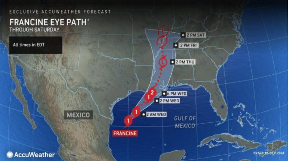
First impacts with the southern coast were expected last night with the storm to track inland though today.
A state of emergency has been declared in Plaquemines Parish, Louisiana, while mandatory evacuations have been issued in Jefferson Parish.
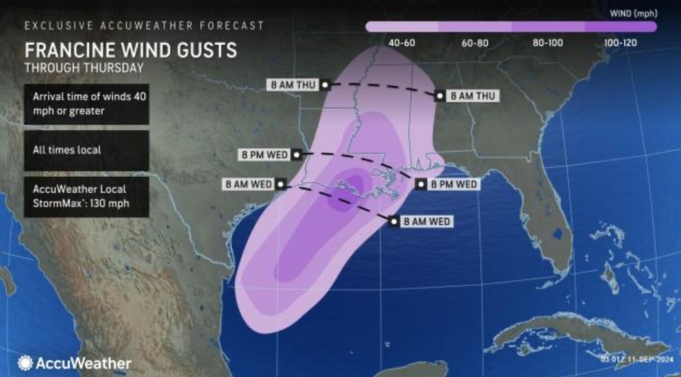
As Francine moves inland through Thursday, winds will be a risk across Alabama, Mississippi, Arkansas and surrounding states
|ACCUWEATHER
Francine is the sixth storm of the season, following Alberto, Beryl, Chris, Debby and Ernesto last month
|ACCUWEATHER
Weather Channel meteorologist Dina Knightly said: “If you're in the potential path of Francine, Knightly says now is the time to take action.
“Evacuation orders have been issued, sandbags handed out and long lines formed at stores and gas stations as parts of Louisiana and Texas brace for Francine.
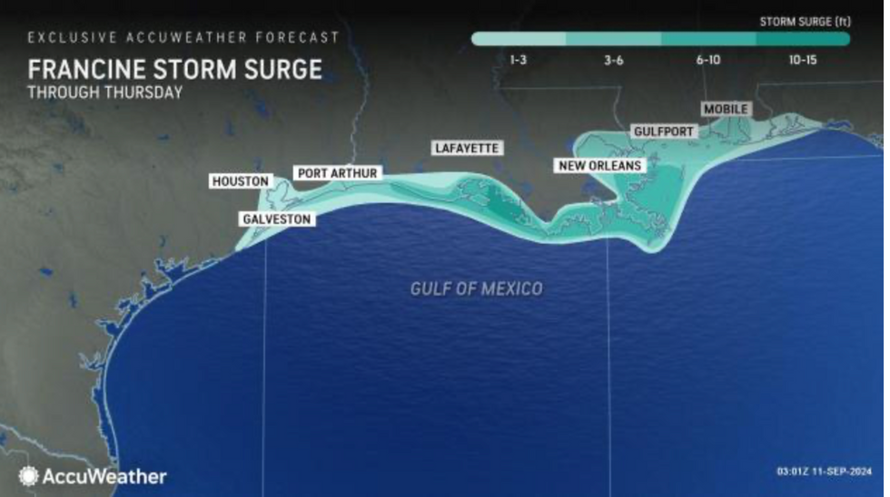
“Flash flooding and surge are the biggest threats, with isolated rainfall totals up to 12 inches and surge up to 10 feet possible.”
Weather experts have urged people to move away from coastal regions, plan escape routes and prepare emergency supplies.
Louisiana’s energy supplier Entergy has warned power cuts could hit 1.3 million customers.
Vice president Steven Benyard said: “We are urging our customers to take the potential of severe weather seriously and stay prepared.
“Now is not the time to let your guard down—please take the necessary steps to ensure the safety of your family and your home.”
Louisiana stands to bear the brunt of the storm with a large threat coming from a 10-foot storm surge.
As Francine moves inland through Thursday, winds will be a risk across Alabama, Mississippi, Arkansas and surrounding states.
AccuWeather senior meteorologist Alex Sosnowski said: “The most dangerous aspect of a landfilling hurricane is the rapid rise of coastal waters that penetrate inland, known as storm surge.
“A broad zone of wind gusts frequenting 60mph to 80mph will occur over much of southern and central Louisiana and part of western Mississippi.
“Winds of this intensity and even lower at sustained speeds are plenty strong enough to knock down trees and trigger regional to widespread power outages, including in New Orleans, Baton Rouge and Lafayette, Louisiana.”
Francine comes as the Atlantic wakes up ahead of what is tipped to be an unusually vicious hurricane season.
Jim Dale, US meteorologist for British Weather Services and co-author of ‘Surviving Extreme Weather’, said: “We are waiting for the hurricane season to properly kick off, but we are already starting to see activity pick up in the Atlantic Basin.
“There is the potential for four of five big ones through the first half of autumn.”