


America will become a nation divided with a crippling ice storm gripping the north as ‘blowtorch’ heat roasts the south.
A tropical plume surging in from Mexico ahead of the weekend will push temperatures in parts into the mid-70Fs.
However, warm moisture hitting cold air from Canada will trigger further storms, experts warn.
In the firing line for the highest temperatures, forecast into the New Year, are south-eastern and southwestern states.
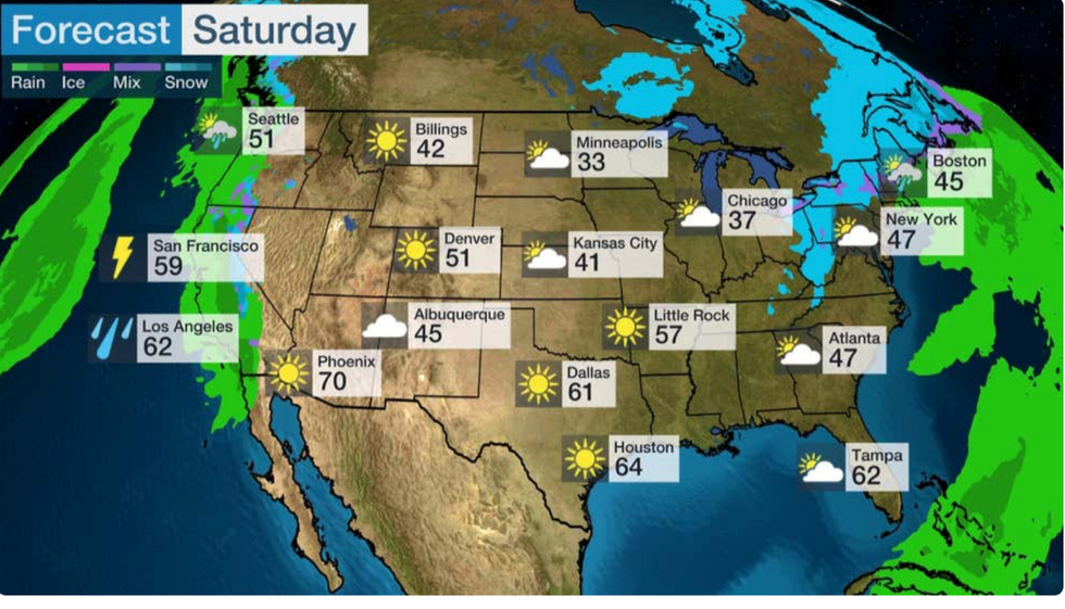
Heating up for the weekend
|THE WEATHER CHANNEL
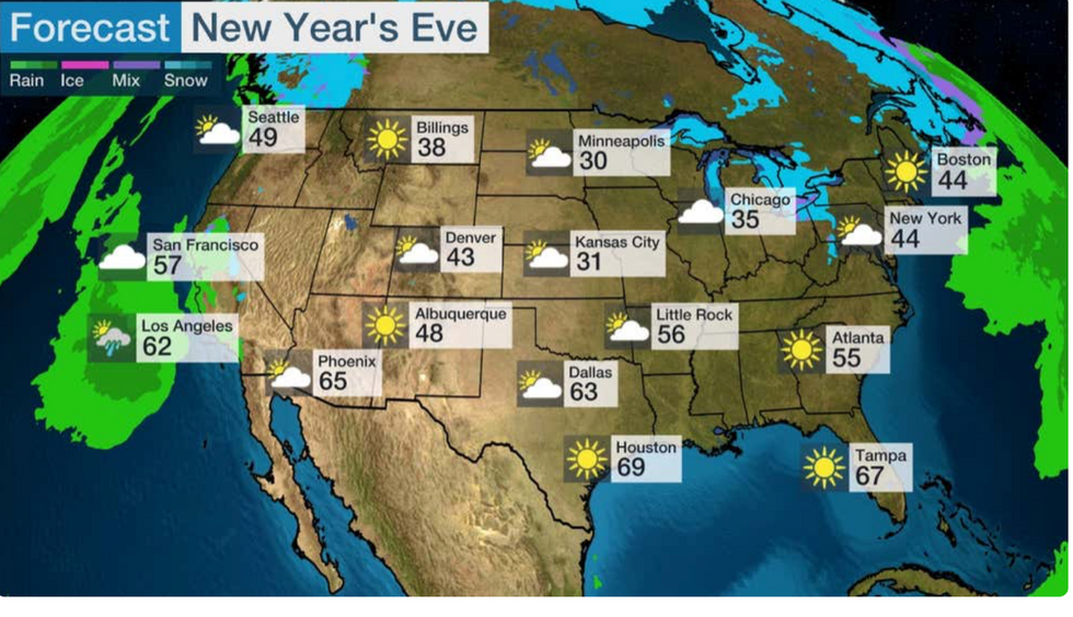
The temperature rise continues on New Year's Eve
|THE WEATHER CHANNEL
Jim Dale, US weather correspondent and meteorologist for British Weather Services, said: “Warm air coming up from Mexico will bring a blowtorch blast of weather after Christmas, with temperatures across the south-west and the southeast above average for the time of year.
“This is a plume coming up from the south, so we will be looking at Florida, Louisiana, Georgia and those states away from the cold air.
“It is unusual, because these places are normally snow covered at this time of year.”
Unseasonable warmth may be the result of a powerful El Nino, which is strengthening after being confirmed in the autumn.
El Nino is caused by a change in direction of the Trade Winds off the coast of South America, causing warm sea water to collect near Peru.
It has global effects on the weather, particularly the Asian monsoon season, but can alter seasonal weather patterns across the US.
Simmering ocean waters, still warmer than average for the time of year, may also fuel the heat surge.
Unstable atmospheric conditions triggered by cold and warm air mixing, though, will further the US’ storm misery.
Dale said: “Where the cold air moves south and meets warmer air coming in from Mexico will be interesting, as this is likely to trigger further heavy rain and stormy conditions.
“There might be a little bit of El Nino in this, and certainly a lag effect of the hot weather over summer leaving ocean temperatures warmer than average.
“The oceans govern the weather, so this is going to be playing a part in these unusual temperatures.”
Meanwhile northern states are reeling from a crippling ice storm which hit in the wake of a Christmas tempest.
The storm is forecast to move eastwards, though it will weaken through the week as the National Weather Service (NOAA) downgrades warnings.
Nebraska, Kansas and parts of Iowa were still under ice storm warnings today while the west coast faces strong winds.
An NOAA spokesperson said: “The system will then shift into the Midwest and Northeast through the end of the week.
“Meanwhile on the eastern periphery of the huge system where mild Atlantic air attempts to overrun the cool ground inland from the Atlantic coast, around of rain is forecast to move up the East Coast.
“Moisture well ahead of a couple of large Pacific cyclones is forecast to keep weather unsettled along the West Coast for the next couple of days.”
Weather experts warn of ‘challenging conditions’ for those taking to the highways and transport networks after the holidays.
More than 115 million people are forecast to travel at least 50 miles this week, according to the AAA.
Weather Channel meteorologist Kait Parker said: “We have got some spots with some sticky travel as we head into the weekend and the New Year.
“By the time we get to Friday and Saturday, that is when we see our next west coast storm heading in.
“So that is when travel plans for the west coast might be a bit iffy, as the east coast clears up.”