


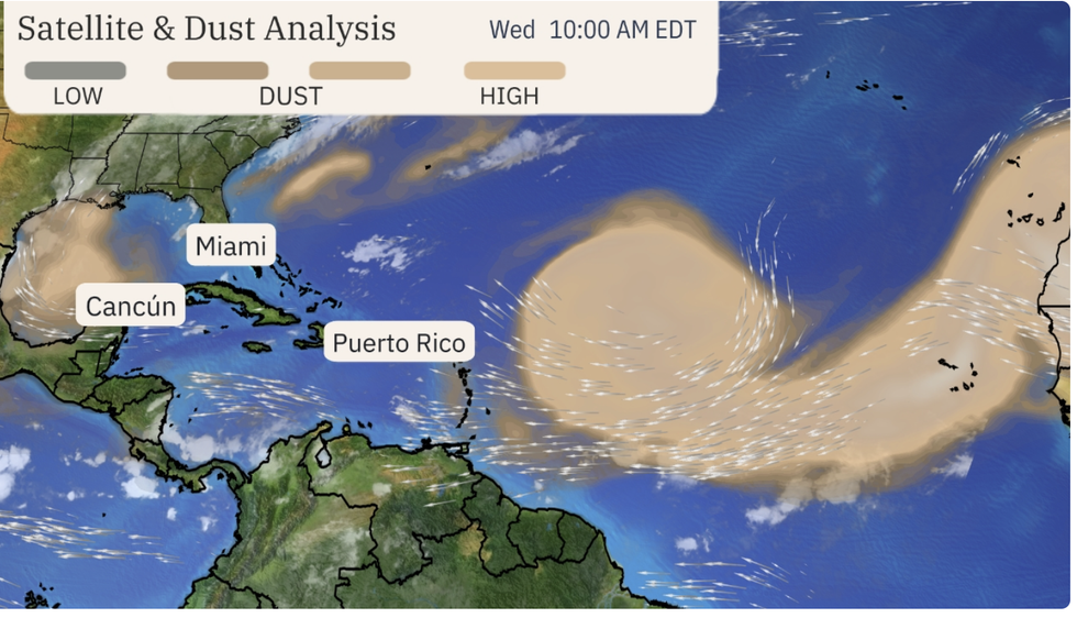
A giant sand cloud muffling the tropical-storm season is about to wash away sending the Atlantic into a hurricane breeding frenzy.
Volatile storm clouds could start to gather after weeks of calm in the wake of Hurricane Beryl’s early July rampage.
A blanket of Saharan dust sweeping the ocean basin over the past few weeks has kept tropical-storm activity at bay.
But it is about to drain away in a torrential deluge, lighting the blue touch paper on the Atlantic hurricane season.
Weather Channel meteorologist Jonathan Erdman said: “The Atlantic Basin has been quiet after Hurricane Beryl, and this is due in part to surges of dust-laden air from Africa’s Saharan Desert.
“But the Atlantic hurricane season may perk up again as soon as early August, and this matches the typical ramp-up in hurricanes beginning in August.
 Warming ocean temperatures, rising air and a change in rainfall pattern threatens a major U-turn | THE WEATHER CHANNEL
“It is still a potentially dangerous season ahead, and many of the same ingredients that have been concerning meteorologists since spring are still in place.”
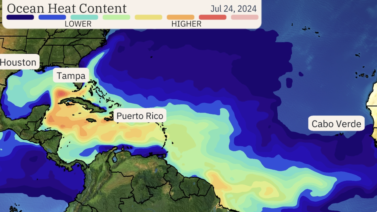
After Hurricane Beryl, a huge cloud of Saharan dust swept over the Atlantic putting a lid on tropical-storm activity.
The region has been usually quiet since, with the threat over the past week coming from inland storms.
However, warming ocean temperatures, rising air and a change in rainfall pattern –the Julian-Madden Oscillation–threatens a major U-turn.
Heavy downpours could wash away the sand cloud turning the Atlantic into a hurricane spawning ground.
Erdman said: “Changes are ahead with computer models forecasting this suppressive tropical environment is going to flip.
“The models suggest a Madden-Julian Oscillation (MJO) may turn the tropical Atlantic to an environment more supportive of tropical storms and hurricanes.
A huge cloud of Saharan dust swept over the Atlantic putting a lid on tropical-storm activity
|THE WEATHER CHANNEL
“Computer models suggest rising air will arrive in much of the tropical Atlantic Basin sometime in early August, and that may end the current dormant tropical Atlantic stretch since Beryl.”
Sand particles sweeping the US coast could ‘seed’ the skies to deliver an early deluge.
Small particles of sand and dust can trigger torrential downpours when they drift into moisture-laden cloud.
Brazil and South America are in the firing line to take the worst hit, although eastern coast states will get a dousing.
Jim Dale, meteorologist for British Weather Services and co-author of ‘Surviving Extreme Weather’, said: “Sand particles in the air coming in from the Atlantic could contribute to the rainfall in the east of the country.
“The particles provide nuclei around which rain droplets form, and this can lead to heavy rainfall.
“Although it is South America that will get the heaviest rainfall, some of it could move slightly northwards into Texas and north-eastern parts of the country.”
In the meantime, raging heat continues to bake swathes of America as wildfires torch western States.
The National Weather Service (NOAA) has warnings in place across the region as thermometers crank up to 110F.
Around the periphery of the heat-dome, cool air colliding with heat and moisture will trigger storms.
A NOAA spokesman said: “Lightning associated with dry thunderstorms triggered by the passage of the cold front will result in critical fire danger over the interior north-western US.
“In addition, monsoonal thunderstorms will continue across the Great Basin and become more numerous over the Four Corners region Thursday into Friday with the threat of localised flash flooding over the next couple of days.”