


BRITAIN is facing a week of snow as the near -10C freeze tightens its grip through the first week of winter.
A tussle between bitter Scandinavian air engulfing the country and Atlantic storms has thrown the UK into ‘unknown territory’.
The first heavy snow of the season this week prompted government meteorologists to issue warnings across Scotland, the east coast of England and the West Country.
Forecasters, however, made a last-minute turnaround from the more widespread that was expected earlier in the week.
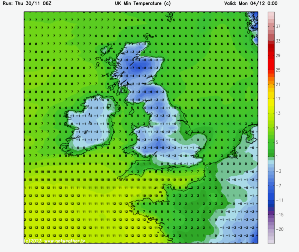
UK weather: Temperatures dip to -9C in the north
|Netweather
Weather models are still predicting snow through the start of the meteorological winter which starts this weekend.
James Madden, forecaster for Exacta Weather, said: “The colder weather with the threat of further snow showers is likely to continue well into next week.
“Although weather models had hinted at widespread snow over the past few days, the low-pressure system that would have triggered that ended up moving off in a different direction, meaning it missed the UK.
“However, snow is in the forecast for the next week, and this could involve well-organised bands of snow possibly reach lower regions of southern England, and something more substantial can’t be ruled out.”
The UK Health Security Agency (UKHSA) has issued cold-weather alerts across northern and Central England.
Elderly and vulnerable Britons are urged to take extra caution as temperatures plunge towards minus double figures.
Heavy snow and ice threaten roads and transport networks while turning roads and pavements into lethal ice rinks.
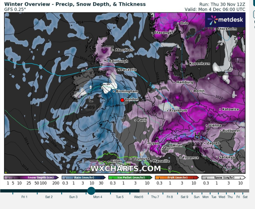
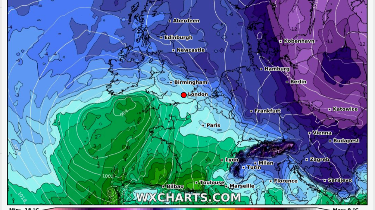
Snow and rain continue to grip Britain through the start of December
|WX Charts
How the cold snap plays out through the start of December will depend on a cold snap gripping Europe and events in the Atlantic.
Jim Dale, social commentator and senior meteorologist for British Weather Services, said: “Europe is giving an indication of what we could see in the UK as we go into the meteorological winter.
“This cold weather could encroach towards Britain, or a region of low pressure could develop that then moves into the cold air over the UK, and that would bring snow.
“It is going to take the Atlantic to hold off what is happening in Europe, so for the time being it is a watching brief to see how this develops.
“We are, at the moment, in unknown territory.”
The Met Office last night issued a nationwide warning for continued extreme cold weather and the risk of snow.
Daytime temperatures will stay below double figures with overnight lows sinking to sub-zero.
North-easterly gusts will keep Britain in the chiller beyond the weekend with wintry showers likely through the start of the month.
Coastal regions will be in the firing line for further snowfall as southern and central areas turn slightly milder and more unsettled, the Met Office said.
Chief meteorologist, Frank Saunders, added: “Snow has already settled in parts of eastern Scotland and over higher ground in north-eastern England.
“Areas such as Dartmoor and Bodmin Moor in the southwest have also seen rain turning to snow and accumulating as it bumps into the cold air covering the UK; some sleet and snow is falling to lower levels too but mostly not settling.
“A number of National Severe Weather Warnings have been issued and these are likely to be updated over the coming days, so stay up to date with the forecast for your area.”