


Tropical hurricane energy dumped in the atmosphere after the mini heatwave will kick start five days of ‘autumnal’ misery.
Temperatures rocketed to 34.8C yesterday making it the hottest day of the year so far, in part driven by the remnants of Hurricane Debby.
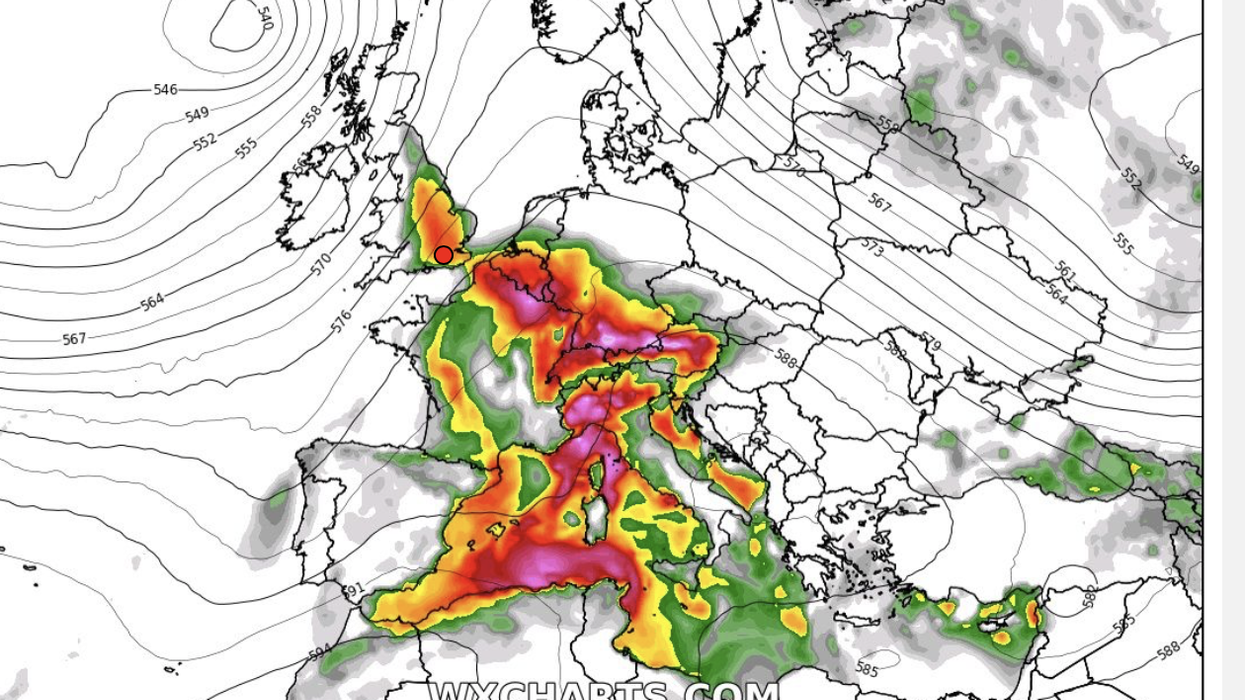
However, heat and tropical moisture drawn in from the south supercharged the atmosphere with huge volumes of energy –Convective Available Potential Energy (CAPE).
As cooler air sweeps in from the west, it will battle this tropical power-pack to unleash heavy rain, gusty winds and the odd thunderstorm.
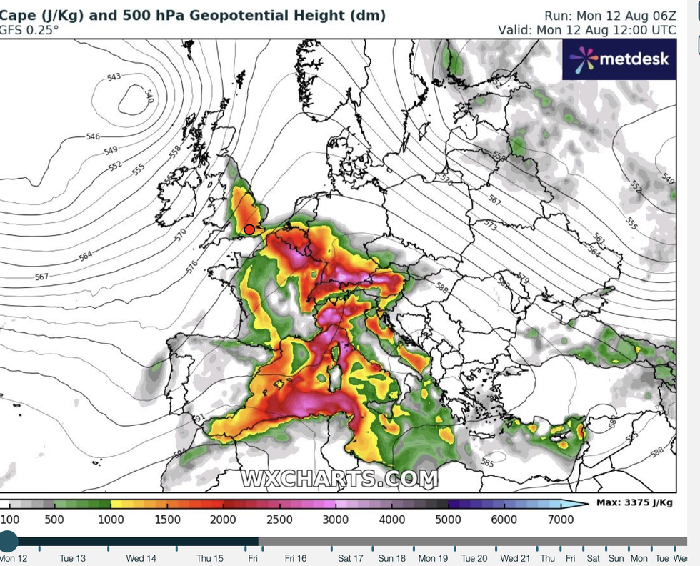
CAPE map showing the amount of fuel available to a developing thunderstorm
| WX ChartsJim Dale, meteorologist for British Weather Services and social commentator, said: “There may be a continued risk of thunderstorms after the hot weather on Monday through the start of the week.
“After the very hot weather, the CAPE levels are going to be high, and this is the trigger for storms.
“This is a result of the warm air left over from ex-Hurricane Debby and the high temperatures we saw across the country after the weekend.”
Hurricane Debby, the second of the season, unleashed a torrent of downpours across eastern America at the end of last week.
LATEST DEVELOPMENTS:It weakened to a tropical storm and then a tropical depression before hitching a ride towards Britain on the jet stream.
Associated low-pressure systems to the west of the UK pulled heat in from the Continent pushing temperatures yesterday into the 30Cs.
They triggered thunderstorms and spells of heavy rain which could linger through the start of the week and perhaps beyond.
Dale said: “The fronts that are coming through are carrying Debby’s ashes, with the jet stream providing the Hearse.
“There is also a lot of energy in the Atlantic, so as we enter a more unchangeable pattern, there could be a risk of heavy rain and thunder.”
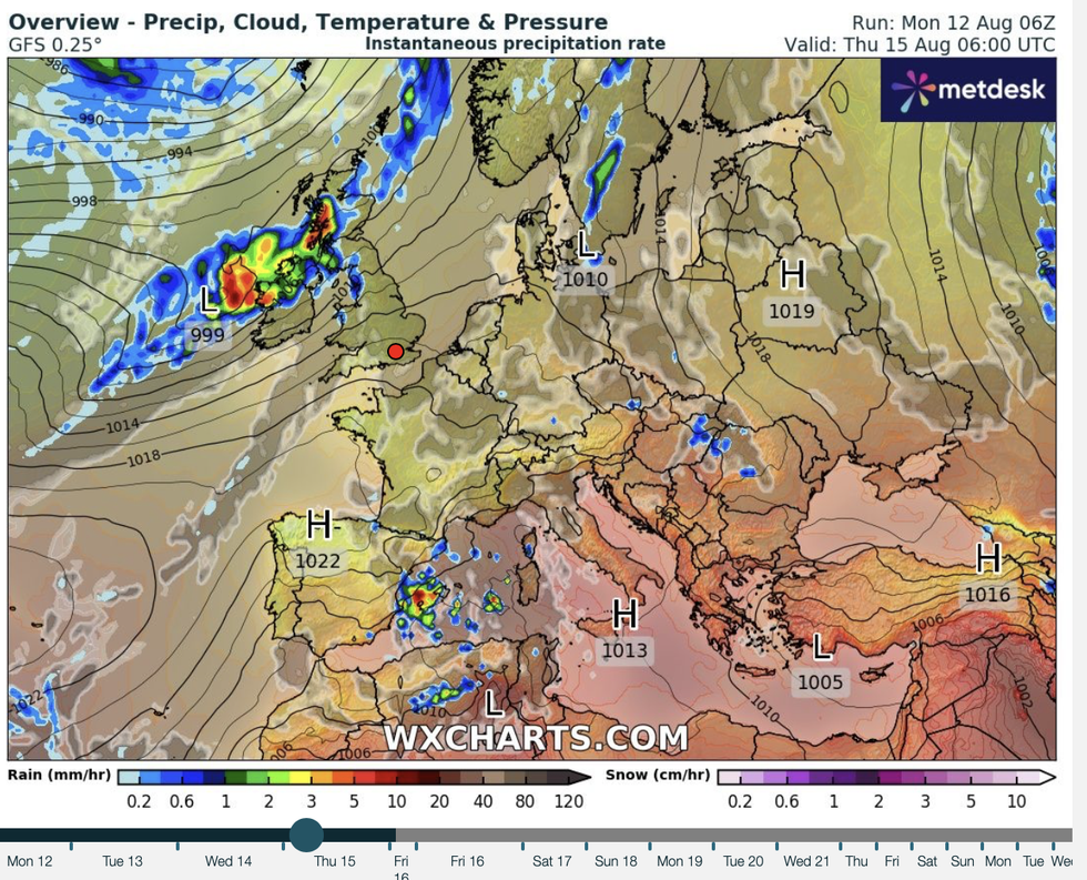
Unsettled weather patterns sweep into Britain
|WX charts
Once again, a southerly wedged jet stream through the coming days will be the driver for unsettled weather.
Temperatures will also drop from the tropical highs of the weekend, bringing a fresher feel across Britain.
Exacta Weather’s James Madden said: “From Wednesday, or possibly earlier, we will see a more prolonged run for a southerly driven jet stream, and this will bring a much cooler and unsettled theme for many.
“It could also feel quite autumnal at times for the height of summer and August.”
Southern and south-eastern England will hang on to the heat through the coming days, while fresher winds cool the rest of Britain.
Temperatures should return widely to average ahead of the weekend, although the risk of rain returns.
The longer-range outlook is a mixed bag of more downpours and the risk of strong winds.
A Met Office spokesman said: “A mobile westerly pattern is expected to continue into next week. Low-pressure systems are likely to track eastwards, probably near to the north of Scotland, but they may also move more bodily across the UK.
“This means cloud and rain will move in from the west at times, perhaps occasionally accompanied by rather breezy or unseasonably windy conditions.”
Bookies, however, are more optimistic with the sight of the sun whetting the axe on hot weather odds.
Coral spokesman John Hill said: “Coral has cut their odds on this summer ending as the hottest on record in the UK.
“On the back of a bright forecast, we have slashed the odds on this summer ending as the hottest on record.”
Ladbrokes’ Alex Apati added: “Things are about to get a whole lot hotter this summer, and as a result, we've slashed odds on a record-breaking August.”