


Britain could be facing an unusually stormy autumn thanks to the knock-on hit from a ‘supercharged’ Atlantic hurricane season.
Around four of five of the possible 20-plus tropical storms threatening America could ‘recurve’ off the US coast and head towards northern Europe.
Hurricanes are impossible in the UK, quickly dying as they leave steamy southern equatorial waters for the north Atlantic.
However, their remnants are frequently steered towards Britain by the jet stream where they embark on a reign of havoc.
Atmospheric G2 meteorologist Dr Todd Crawford said: “The season can best be characterised as lacking in weak storms, with stronger storms still on pace for what would be considered a highly active season.
“We are forecasting 16 more named storms, and are predicting two more hurricanes, which would be four in total after Beryl and Debby, to make landfall along the US Coast, with four to five recurving into the North Atlantic and towards Europe.”
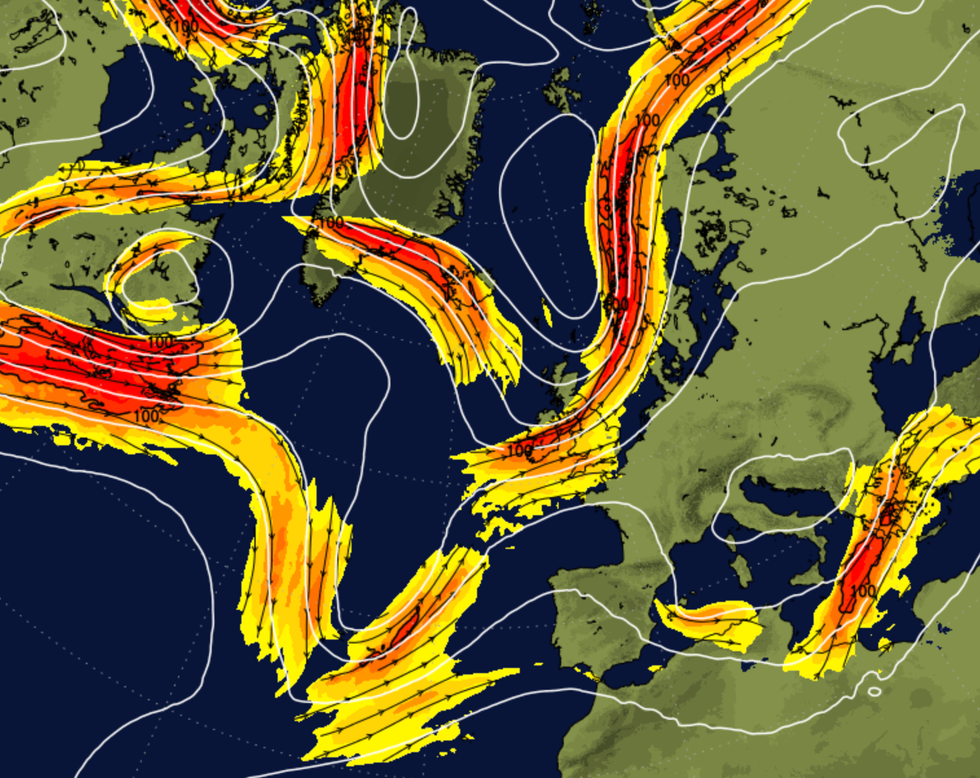
The jetstream plays a large role when it comes to the weather across the UK
|NETWEATHER
The tropical hurricane season has so far spawned five major storms Alberto, Beryl, Chris, Debby and Ernesto, which in late August whipped up a brief wet and windy spell in the UK.
High ocean temperatures will contribute to an unusually active season this year, with the US east coast and Caribbean taking the brunt.
But hurricane remains could end up being swept into Britain’s weather patterns, bringing stormy or unusually warm conditions.
Jim Dale, US meteorologist for British Weather Services and social commentator, said: “The remains of hurricanes can often end up affecting the UK weather patterns through the autumn, and it is even more likely this year given the expected increase in tropical Atlantic activity.
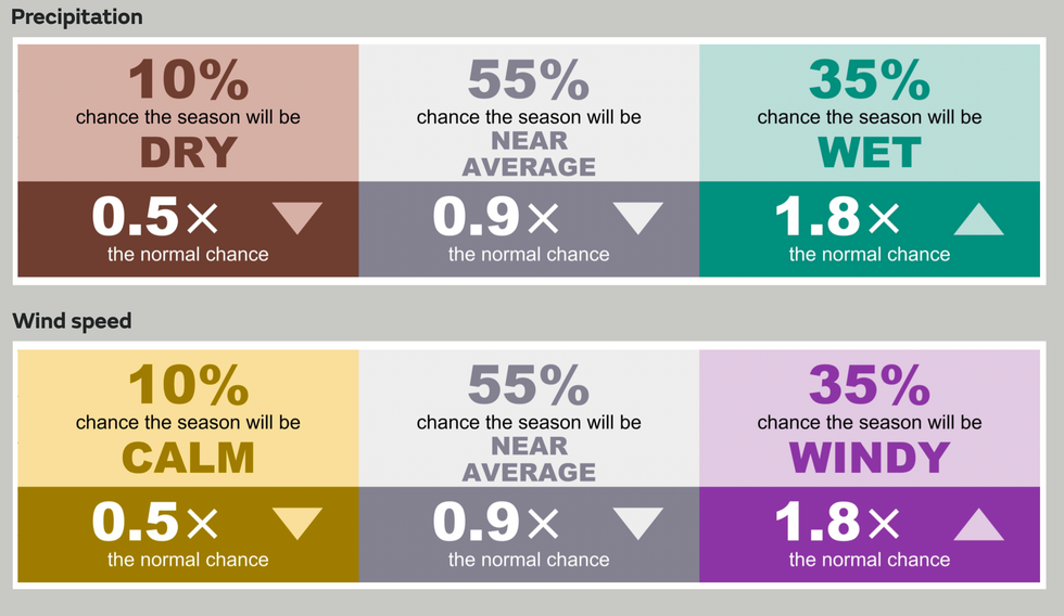
Met Office’s autumn outlook
|MET OFFICE
“Sometimes they can join with a usual storm system to invigorate it, bringing wet and windy weather, but they can also pull warmer air up from the south.
“This depends on the position of the jet stream and the path taken by the energy left from the tropical storm.”
Tropical weather experts warn this year could bring higher than usual numbers of hurricanes to the Atlantic basin driven in part by a La Nina cooling of the eastern pacific.
A plume of Saharan dust which swept across sea waters disrupted storm formation earlier in the season.
This has now dissipated, leaving in place all the ingredients for a breeding ground of tropical storms.
AccuWeather has warned a ‘supercharged September’ threatens between six to 10 named storms in the southern Atlantic.
Meteorologist Jon Porter said: “Despite the recent lull in the tropics, we are urging people to prepare for an uptick in tropical threats in the month of September and beyond.
“While a total of 20 to 23 named storms is most likely, we cannot rule out 24 or 25 due to factors including reduced wind shear as the season progresses, very warm water, an intensifying La Niña through autumn and the forecast of less dry, dusty air present in the atmosphere over the tropical Atlantic Ocean.”
Met Office head of warnings Will Lang said: “Overall for the UK as a whole, the season has an increased probability of being wetter and windier than average.
“It doesn’t mean it will be, it just means the odds are shifted a bit in favour of those outcomes.”