
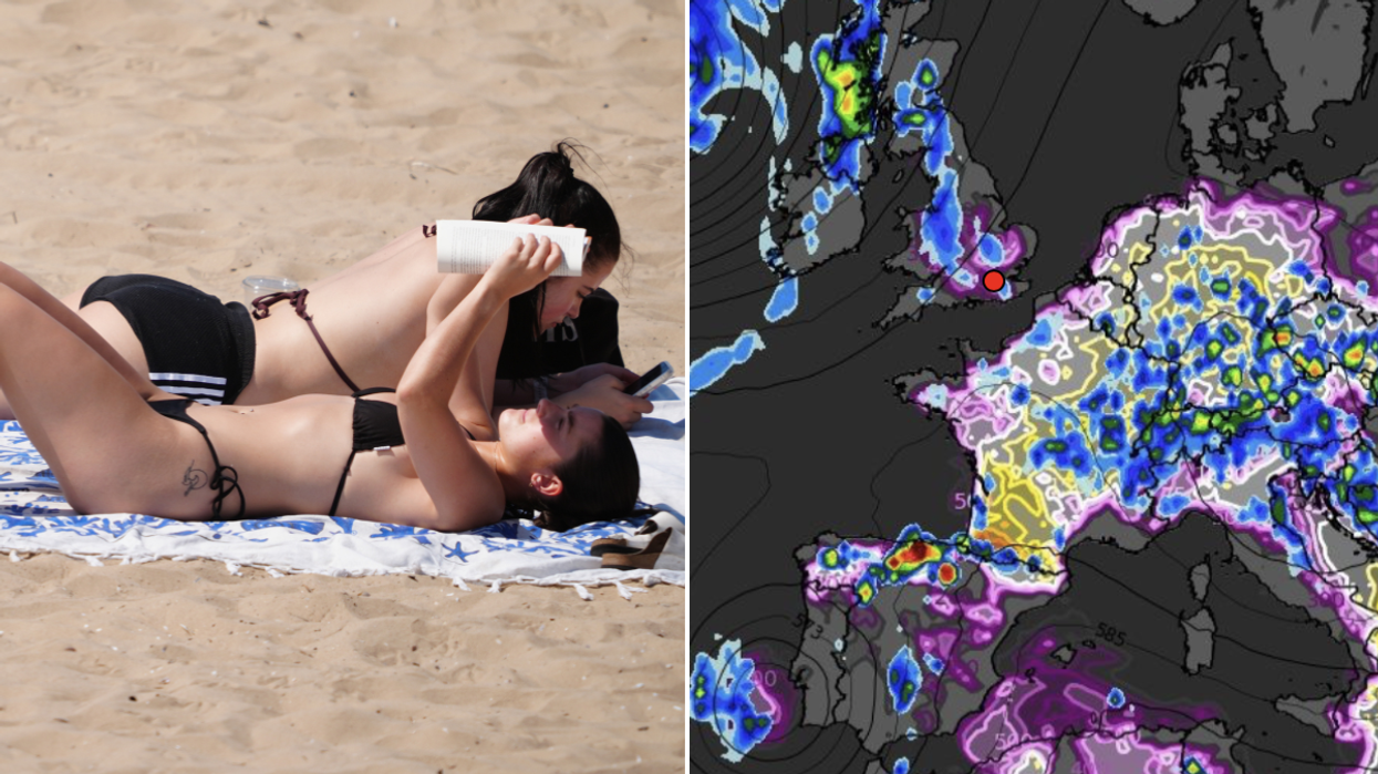


Britain’s mini scorcher will end with a bang with 30C heat to give way to a weekend of thunderstorms.
Searing temperatures and humidity will plough copious energy into the atmosphere bringing the hot spell to a volatile climax.
Blazing sunshine is expected to last until Friday when the heatwave will erupt into an explosive deluge.
Jim Dale, meteorologist for British Weather Services, said: “There may be dribs and drabs of rain and thunder during the start of the week, but it is Friday when things are really expected to fall apart.
 Temperatures will reach 30C before thunderstorms take over | PA/WXCharts
“There is the potential for some very heavy rainfall and thunderstorms, and this risk will last into the weekend.
“It is then likely to turn cooler, with Saturday looking like the real demarcation point between the hot spell and a return to more usual conditions.”
Rapidly rising temperatures will cause heat to rise into the atmosphere, feeding it with energy to fuel storms.
High levels of CAPE – Convective Available Potential Energy – will drive the eruption, experts warn.
Mr Dale said: “We are looking at the CAPE levels at the end of the week and into the weekend, and they are huge over Europe, and this looks like nudging into parts of the UK.
“This will lead to unstable atmospheric conditions, and consequently the risk of large thunderclouds and storms.
“In addition, on Saturday more conventional weather fronts will move into the UK, and this will add to the risk of unsettled weather.”
LATEST DEVELOPMENTS:
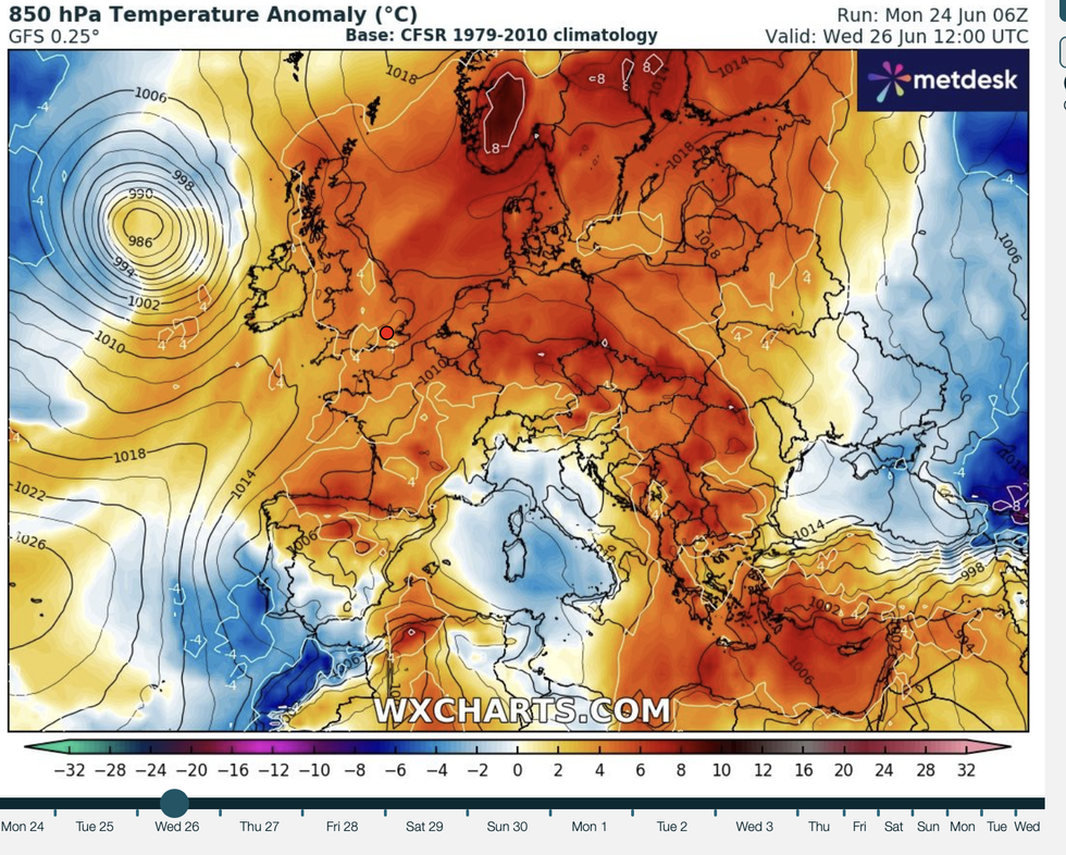
Rapidly rising temperatures will cause heat to rise into the atmosphere, feeding it with energy to fuel storms
|WXCharts
Thermometers are forecast to rise through the coming days, with southern and south-eastern Britain possibly nudging past 30C.
A huge region of high pressure –the Azores High– will stretch from the tropics to Britany igniting the furnace.
A government heat health alert issued by the UK Health Security Agency is in force until Thursday.
Elderly people and those with health conditions are urged to take extra care as the mercury soars.
Motoring experts have warned people heading out and about to prepare for extreme heat on the roads.
AA president Edmund King said: “High temperatures can be dangerous if you breakdown or get stuck in congestion.
“Ensure you have enough fuel or electric charge to keep your air-conditioning running.
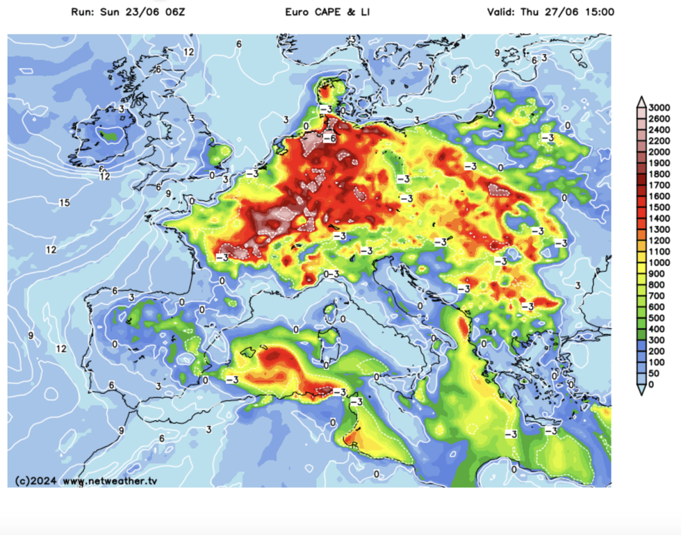
Atmospheric energy (CAPE) rising in Europe and into the UK
|Netweather
“Severe heat could cause considerable problems for many older vehicles without air-conditioning or recent servicing, with both the car and occupants over-heating.
“Be aware of the dangers and never leave children, the elderly and animals in over-heated vehicles.”
While the heat is expected to break ahead of the weekend, the next scorcher may not be far behind.
Some long-range experts say temperatures will rocket after the weekend with roasting sunshine on the menu into July.
Exacta Weather’s James Madden said: “The hot weather will temporarily ease across parts of the north around Thursday and Friday, with a “thundery breakdown” likely in parts.
“It looks favourable for high pressure to make a quick return and become quite influential on our overall weather pattern, and this would mean further warm to hot conditions developing around next weekend and during early July.”